
Fusafjellet from Strandvik (18.05.2024)

Written by HHauser (Helwig Hauser)

| Start point | Strandvik (25m) |
|---|---|
| Endpoint | Strandvik (25m) |
| Characteristic | Hike |
| Duration | 6h 00min |
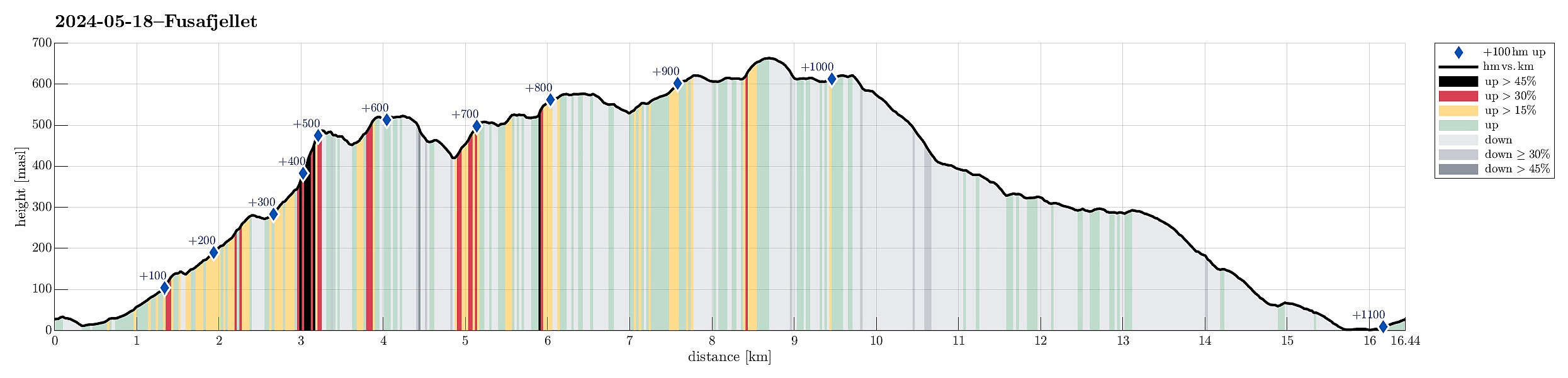
| Distance | 16.5km |
| Vertical meters | 1,119m |
| GPS |
|
| Ascents | Fusafjellet (665m) | 18.05.2024 09:00 |
|---|---|---|
| Langnuen (492m) | 18.05.2024 09:00 | |
| Nordre Langnuen (526m) | 18.05.2024 09:00 | |
| Vetlahorgi (627m) | 18.05.2024 09:00 | |
| Visits of other PBEs | Breistølshytta (405m) | 18.05.2024 09:00 |
| Dalabruo (35m) | 18.05.2024 09:00 | |
| Øykjanuen (577m) | 18.05.2024 09:00 |
Trip Summary
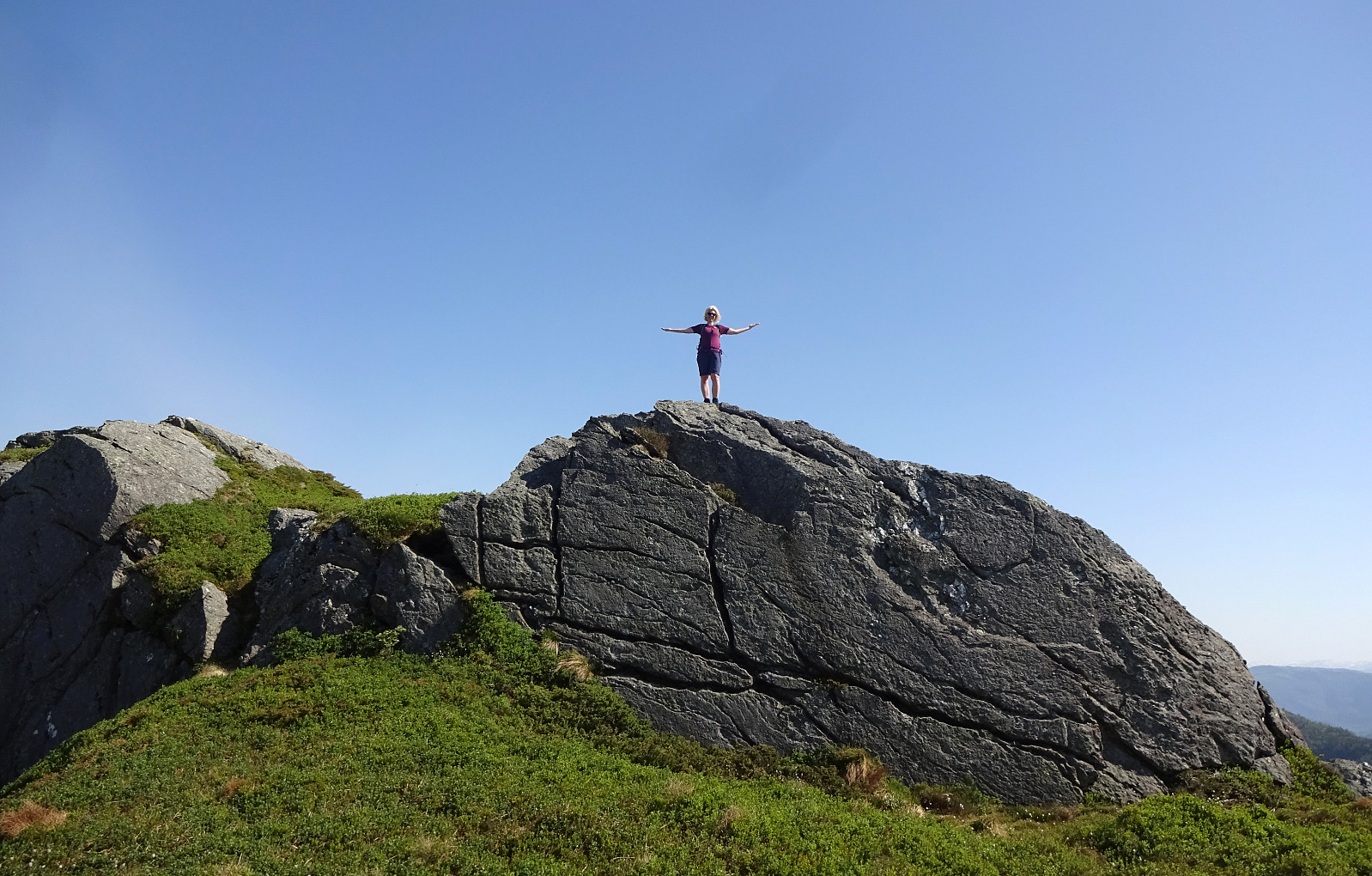
Given a very nice (and warm!) day, we aimed at hiking Fusafjellet from the south, starting in Strandvik. We first headed into the valley between Fusafjellet in the northeast and Bogafjellet in the west, where Vikaelva comes down. At about 80 masl, in the northeast of Nyland, the valley opens up a little and we left the main gravel road, stepping "directly north", aiming at the little saddle in the east of the small hill that "sits" there in the middle of the valley. The plan was to continue further upwards (into the direction of Langnuen) from there, but before we did that we first explored this little hills for a few minutes, enjoying some nice views southwards from it. We then followed a forest road that ascends the relatively steep southwestern side of Langnuen. At about 275 masl, we crossed a wet area to the north, starting the real ascent to Languen shortly after. The last 150 height meters up to Langnuen are very steep, but following the trail makes this ascent "straight-forward". From Langnuen, we then enjoyed really nice views (in particular southover). At Langnuen, the slightly more explorative part of our hike started: We wished to first cross over to Nordre Langenuen, then further to Øykjanuen, before later reconnecting with a trail that leads up to Vetlahorga as well as Storahorga, i.e., the two main tops of Fusafjellet. The terrain south of Øykjanuen is substantially rugged, with numerous cliffs. Crossing over this southern part of Fusafjellet requires finding the places, where making progress is actually possible. From Langnuen, we first aimed at the saddle between Langnuen and Nordre Langenuen (in the northeast of Langnuen). Walking around and along some cliffs, we actually reconnected with the trail that leads down from Langnuen towards the east for a moment, before actually finding a spot, where we could cross over to Nordre Langenuen. Ascending to Nordre Langenuen from the saddle in the south, however, was easy, even without a trail. Also Nordre Langenuen offers wonderful views, especially towards the south--west--north. The next challenge was to find a good way to get over to Øykjanuen. Some nine years earlier, an somewhat more eastern route proved possible, when crossing southover from Øykjanuen to Nordre Langenuen; this time, however, we had seen what looked like a reasonable ledge in the north of Nordre Langenuen, leading "diagonally" across steep northwestern side of Nordre Langenuen into Svingardalen. See the inset further down, also, where this traverse is highlighted.
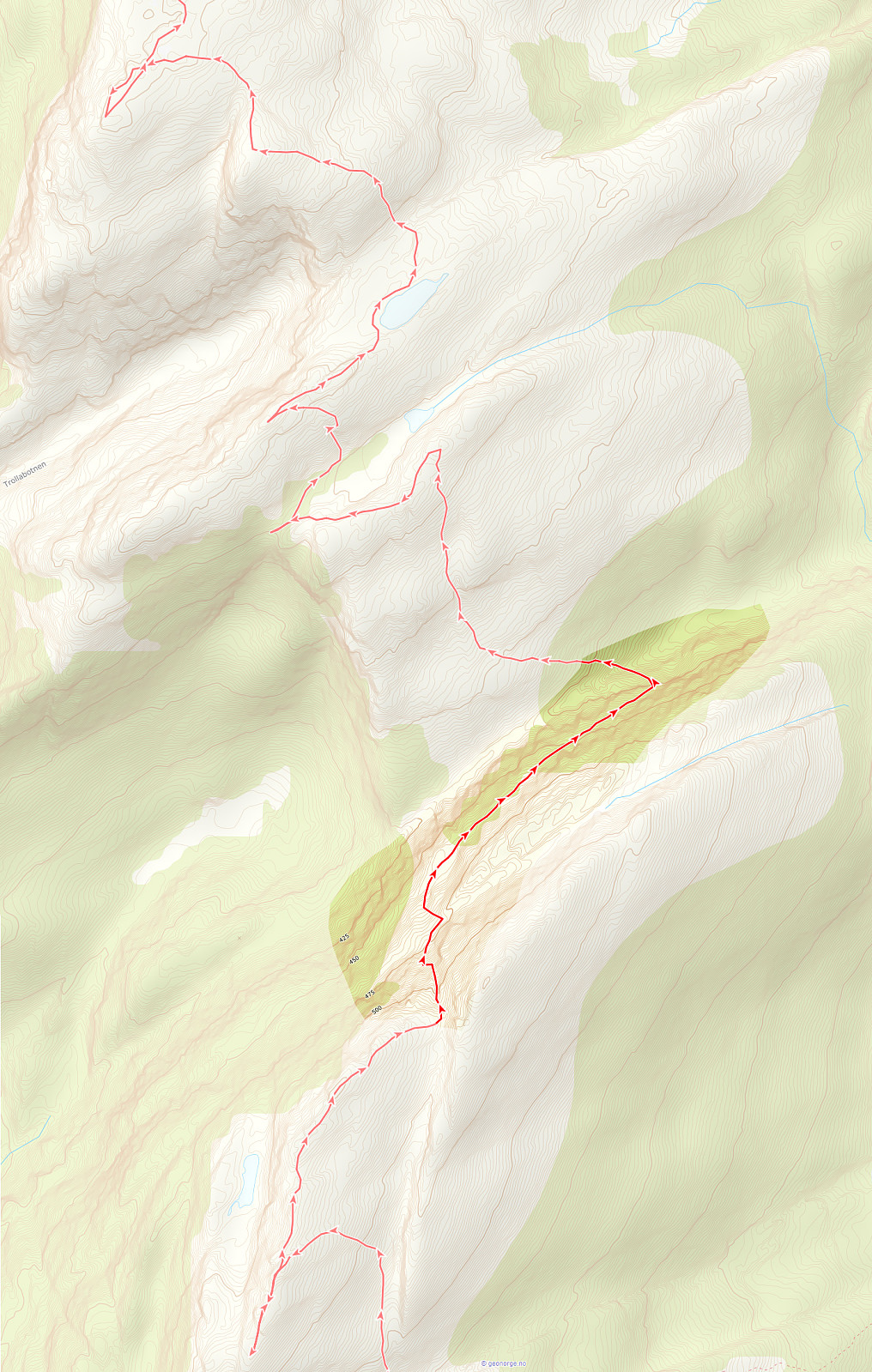
Once down in the upper end of Svingardalen, the ascent further northwards was again straight-forward. After getting up to about 500 masl, another small valley needed to be crossed (not difficult, but finding the right spot, where the continuation further upwards towards the north was possible, required a bit of back-tracking). After making it up to the next ridge (at about 530 masl), we passed by a nice little lake, before continuing further upwards to Øykjanuen. While the terrain is partially steep there, all of this was without real difficulties. Once on Øykjanuen, it was again time for enjoying some nice views! :-) Continuing further from there (towards Vetlehorga and Storahorga) then became easy and nice -- across the heights of Fusafjellet. Most of this continuation was then also on the main trail that comes up from Botnane just a little north of Øykjanuen. At Storahorga, we had a nice lunch, before starting our hike back to Strandvik. From Storhorga, we first followed the main trail back to Vetlehorga. From there, however, we aimed at Breisetret in the east-southeast of Vetlehorga. From Breisetret, then, we followed a marked trail in southern direction (which is not exactly aligned with the trail-mark on the map). Sufficiently high above the significantly steep Ramslia (towards the east), we made it then down and across Svingardalen (again, just now further east). Only about 200 meters further south, the trail connected to a forest road that comes up there from Strandvik. We then followed this forest road down to Hauge in the northeast of Strandvik (and then further down to Strandvik). All in all, this hike was really nice (also the weather was very nice!) -- still, it was again impressive to see how challenging the southern end of Fusafjellet actually is (compared to the very easy-going northern part)! :-)
Photos
Selected photos are available as Google photo album.
Useful Resources
See also the related FB-page Hiking around Bergen, Norway.
Web page WestCoastPeaks.com provides useful information about Storehorga and Langenuen
and also Petter Bjørstad has a useful page about Fusafjellet.


User comments