
Fusafjellet (30.08.2015)

Geschrieben von HHauser (Helwig Hauser)

| Startpunkt | Fusa (20m) |
|---|---|
| Endpunkt | Fusa (20m) |
| Tourcharakter | Bergtour |
| Tourlänge | 6h 30min |
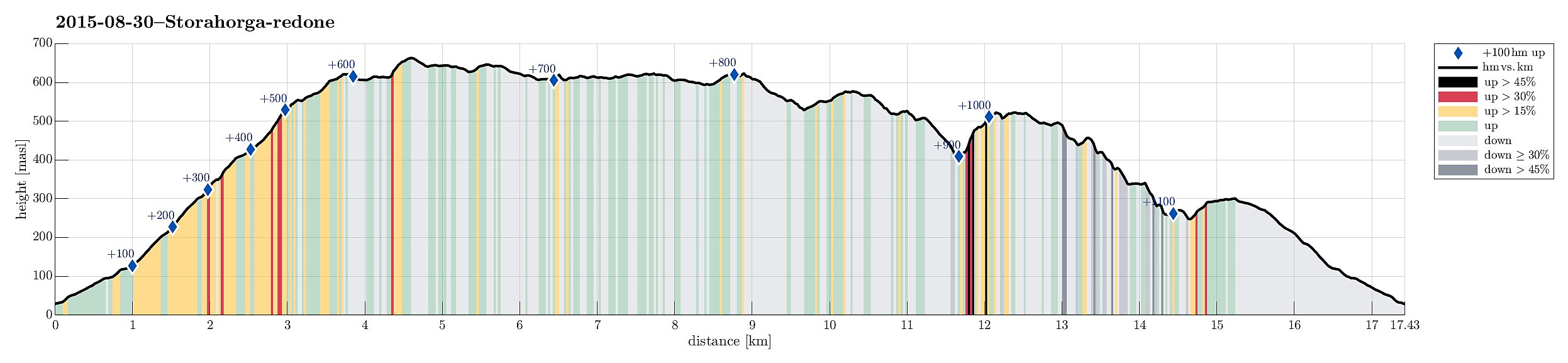
| Entfernung | 17,4km |
| Höhenmeter | 1.173m |
| GPS |
|
| Besteigungen | Fusafjellet (665m) | 30.08.2015 |
|---|---|---|
| Nordre Langnuen (526m) | 30.08.2015 | |
| Vetlahorgi (627m) | 30.08.2015 | |
| Besuche anderer PBE | Grautkjerringa (394m) | 30.08.2015 |
| Håland p-lomme (78m) | 30.08.2015 |
Trip Summary
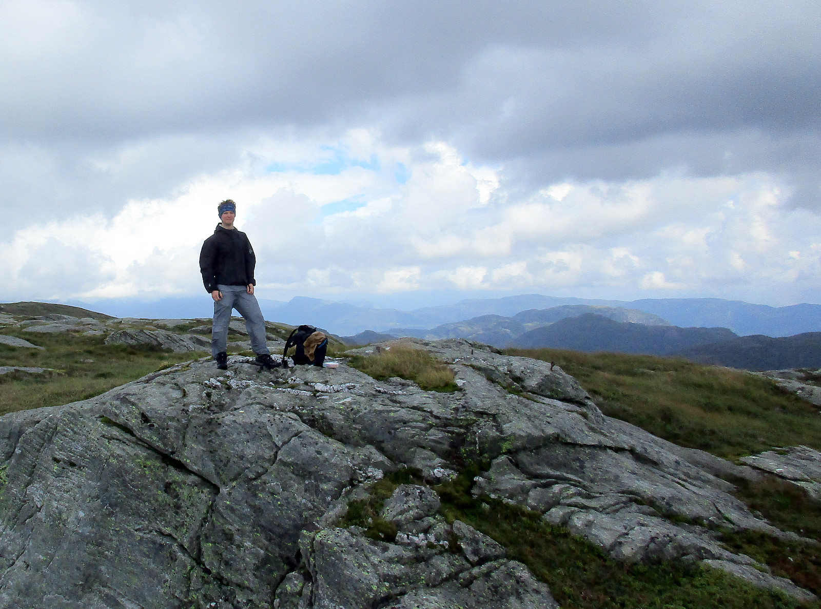
We took the ferry from Hattvik to Venjaneset and continued -- only a little less than 3km -- to Fusa. We parked the car right next to the street, where it crosses Sagelva and where a sign points towards the old postal path (gamle postveien) -- not at the least as also recommended by the page about Storehorga and Langenuen on WestCoastPeaks.com. We first went up a simple street called Øpstad (on the eastern side of Sagelva), which connects directly to a useful forest road, leading up the valley. At about 125mosl, we came to a road fork, continuing on the left, further up. At about 300mosl, another trail fork opens up for different alternatives -- we turned left, again, following the most direct route up to Fusafjellet (from there). Ascending a little further from there, we left the tree line below us and started to enjoy the many nice views that Fusafjellet has to offer (this continued like this for the next couple of hours!). Slightly higher than 500mosl, we reached the high areas of Fusafjellet, not far from Vetlehorga. We continued towards Storahorga (now mostly northwards) and reached the top about 90mins. after having left the car -- not at the least due to very nicely marked paths and pleasant terrain, this ascent was really fast and easy. From Storahorga, we continued northwards (in order to reach some point from where we would have a nice overview of the fjords in the north of Fusafjellet), more and more, now, without any path (if you don't mind wet shoes, walking over Storahorga without any path is really no problem at all). After having enjoyed the views to the north, we basically made a large round (on the eastern side of Storahorga) that eventually brought us back to Vetlehorga -- Vetlehorga, in fact, sits somewhat in the middle of this extended mountain and offers nice views in all directions! From there, we first followed the path back to the place, where we had first reached the higher area of Fusafjellet. There, we decided that adding another extra round -- this time in the south of Fusafjellet -- would be nice. We first ascended to Øykjanuen, where it became obvious that the southern end of Fusafjellet -- while all in all a little lower than Storahorga -- is much more mountainous (varied, steeper terrain; rocky; including places, where ascending/descending becomes significantly challenging)! First on Øykjanuen -- as well as then also on further small tops further south -- we truly enjoyed the fantastic views! We then continued southwards, in the direction of Langnuen -- all the time without a path and taking good care of our steps (due to the semi-wet weather the ground was slippery [and increasingly steep!]). We descended all the way down into Svingardalen -- quite a deep crevasse, separating Langnuen from Fusafjellet. On the other side, the terrain became even more steep and we considered extra-carefully where to climb up (it seemed clear to us that returning the same way down would have been extra-challenging -- maybe impossible!). Having made it up to Langnuen, we again enjoyed magnificent views -- wow! Soon after, however, the challenge of how to get down, again, started. We first crossed all of Langnuen (Nordre Langenuen) towards the southwestern end of it. There it is pretty unclear of where to get down, actually! We first descended "one level down" to a (still quite high) area with a small lake. There, we first tried our luck at the northern end of this area -- just to find out that it seemed all too steep there. Walking back across this higher area, now southwards, we checked its western end carefully and thereby found a hint of a trail, somewhere half the way back on this higher area. We managed to descend "another level down" there, reaching another half-high area that extended from north to south there. We first followed this area southwards, checking whether we could follow a small stream that also used this path. After some 100m, or so, we found out that this would not work and so we turned right, again, rounding a smaller hill there and getting back onto a northern direction. Again, we detected another "hint of a trail" there and followed it "another level downwards -- in the direction of Øykjadalen. This way, we made it into Øykjadalen and arrived there at about 350mosl. From there, we aimed at crossing along the mountain side, partially following further "hints of trails" (maybe animal trails). The terrain is steep, there, but with care and some extra time, one can make it across (and down). Eventually, we managed to connect to the forest road that follows Vikadalen. We took this one up to Vikahaugen (basically the saddle towards Fusa) and then further northwards, all the way down to Fusa on the other side. In the end, we arrived at the car after about 6.5h of hiking -- we clearly recognized that our legs had done some exercise, but were also very satisfied with this nice and adventous trip! :-)
Photos
Selected photos are available as Google+ photo album.
Useful Resources
Web page WestCoastPeaks.com provides useful information about Storehorga and Langenuen
and also Petter Bjørstad has a useful page about Fusafjellet.


Benutzerkommentare
I think we met
Geschrieben von Stigun 19.07.2016 22:56that day at Fusafjellet. My wife and I made the climb the same day. My wife, ascending, said she talked to two men from Austria(?) on their way down from the summit, while I was away from the main trail on some secondary summit(Vetlahorgi?), but a minute or so later I also passed you and your hiking companion on the trail; greeting :-)
Re: I think we met
Geschrieben von HHauser 03.08.2016 11:47Nice! That was a wet hike (but very nice!). :-) And finding the way down from Langnuen was a challenge, too. :-) But clearly I like thinking back to this hike (also this one, as to so many). My companion, BTW, is a Czech citizen. Anyway: we are all enjoying the wonderful surroundings of Bergen! :-) All the best! Helwig.