
Rindafjellet from Gåssand (wow!) (21.05.2023)

Geschrieben von HHauser (Helwig Hauser)

| Startpunkt | Hatlelio parkering (75m) |
|---|---|
| Endpunkt | Hatlelio parkering (75m) |
| Tourcharakter | Wanderung |
| Tourlänge | 8h 00min |
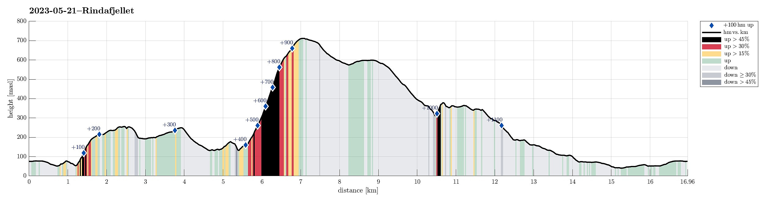
| Entfernung | 17,0km |
| Höhenmeter | 1.177m |
| GPS |
|
| Besteigungen | Midseterfjellet (604m) | 21.05.2023 |
|---|---|---|
| Rindafjellet (715m) | 21.05.2023 | |
| Skantane (261m) | 21.05.2023 | |
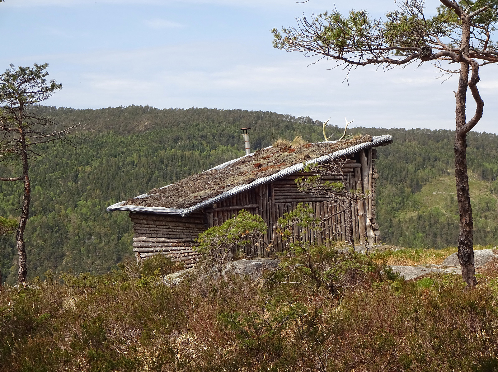
| Besuche anderer PBE | Skantane gapahuk (252m) | 21.05.2023 |
| Hatlelio p-plass (74m) | 21.05.2023 | |
| Varden på Midseterfjellet (599m) | 21.05.2023 | |
| Varden på Rindafjellet (690m) | 21.05.2023 |
Trip Summary
We expected a nice Sunday and headed out for a special "project": Rindafjellet from Gåssand! This clearly became a bit of an adventure and (quite) a bit of a challenge, also. It may be good to read the following before possibly retracing our hiking track (the hike was very nice, yes, but also a bit long and very steep up to Rindafjellet!).
Skantane
We drove south from Bergen (along E39 into the direction of Os) and took the small road that leads to Gåssand, after all. Before actually coming to the south end of Ytsta Raudlivatnet, however, we parked at the relatively large parking spot near Hatlelia. From there, we then first walked further along Gåssandvegen, crossing Nordelva north of Gåssand. At the other side of the bridge, we turned left and followed a track across Nauslia that brought us conveniently to the lower end of Stordalen. From there, our plan was to ascend Austerlia into the direction of Skantane. This mountain side of relatively steep, we could not make out any trail, or the like, and the rather dense vegetation (short needle trees in the lower section, juniper bushes further up) required a bit of extra motivation to get through and up there. At about 200mosl, however, the situation improved and walked across the heights of Skantane was then no longer a challenge. We somehow thought that we would connect with a trail that the map shows on the southern side of Skantane, but that did not happen (for once, we were a bit too high, already, and for the other part, it's not clear to which degree this trail really exists, also). Eventually, we made it to the top of Skantane without difficulties and enjoyed some nice views over Insta and Ytsta Raudlivatnet from there. We also found the place, which most likely hunters use (close to the top of Skantane).
Randifjellet from the West
Motivated by a hike in 2022 of Mathias Chr. Mathiesen we aimed at a similar route up to Rindafjellet. To get there from Skantane, we had planned to pass over the top of Rotveltelia (via Ytsta and Insta Bøskaret). We thus first descended from Skantane (in northeastern direction). This part was steep, but did not cause any mentionable difficulties. Once down (in the southeast of Ytsta Bøskaret), we then continued in nothern direction, first stepping up through the valley on the west of Barlindlia. Instead of continuing further up into Barlinddalen, however, we turn half-left, crossing the saddle there, and aiming at Insta Bøskaret from there. All of this is basically without any trail (maybe some deer tracks, though), but still without major difficulties. Once down to about 130mosl, we came to a rather wet spot in this valley. There, we turned half-right and crossed over to a little stream that comes down from Munkelia. While thinking that we had found Sølverelva, we in fact were a bit to the southeast of it. After first hiking up from there a bit, we understood that we were still too far south and decided to cross over "diagonally" to get into the valley of Sølverelva. Once there, we first walked up the valley a little bit (on the east-side of Sølverelva), but then headed for a more direct approach to the ascent. This lead to a long and very steep ascent across the western slope of Randifjellet (quite a bit further south of where Mathias Chr. Mathiesen had stepped up. All in all, it was very well possible to step up there through the forest in that we did not face any cliffs, of the like, which would have made this ascent more difficult. Still, just because this ascent is really steep, one needs to evaluate ones physical condition and see whether this route is one that actually is a good idea. :-) Once above the tree line, progress became a little easier (less steep terrain) and we enjoyed very nice views! After all, we arrived at the top of Rindafjellet, enjoying a nice break there. :-)
Back via Steindalsåsen
From Rindafjellet, we had thought to hike back with Midsæterfjellet, first, and then via Steindalsåsen down to Bødalen. Hiking over the heights of Rindafjellet and Midsæterfjellet was then very nice and enjoyable, but finding the trail (as marked on the map!) that should lead us down Bukkaberglia to Steindalsåsen was something we did not manage. We checked several times for this trail and asked also some other hikers, but could not find it. Given our exploration, we suspect that this trail does not really exist. In trying to find this trail (and in not being very keen on an off-trail descent via Bukkaberglia, possibly involving some little bush war on the way down, we ended up descending via the main trail down from Midsæterfjellet quite a bit more than what we originally had planned. Before getting all to far down Bukkaberget, however, we eventually left the trail and made a diagonal connection into Steindalen, where we found a simple tractor road at about 300mosl. We then followed this tractor road up, before it ends not so very much higher, actually. Finding ourselves there on the upper part of some rather steep terrain, we decided to get further into Steindalen by following the high "edge" of this steep terrain. Eventually, we found a convenient way to get down into the lower parts of Steindalen -- basically where the trail should have down via Bukkaberglia (no trail to see anywhere, however). The plan was then to find the valley that would lead us down from Steindalsåsen to Bødalen. With a bit of back and forth, we eventually found the right valley and descended it down to Bødalen. Also here, one should conclude that the trail, which is marked on the map through this valley, does not really exist. Once in Bødalen, however, we successfully got onto a proper trail (more like a tractor road, actually) and descended it further down (into Bjørndalen). Further down in Bjørndalen, this track becomes even more like a proper tractor road and walking it out towards Gåssand is then straight-forward and easy. At Bastiansmyra, we then stepped out onto the gravel road (Gåssandvegen), which we then followed down and out to Gåssand. From there, it was then just to walk back to the parking spot (along Gåssandvegen).
Conclusion
Altogether, this (long and partially very steep) hike was very nice and a good way to use a beautiful Sunday. The area between Ytsta and Insta Raudlivatnet (on the southwest) and Midsæterfjellet (on the northeast) is apparently frequented by hunters, but maybe not so much by hikers, after all. Quite a few of the trails, which we had seen on the map before starting, turned out to not be there in reality. While this was no problem along much of this hike, it was a bit annoying when trying to connect from Midsæterfjellet (via Steindalsåsen) to Bødalen. At the end of the day, after 17km of hiking (with about half of that off-trail) and about 1000hm up, we clearly recognized that we had done some exercise! :-)
Photos
Selected photos are available as Google photo album.
Useful Resources
See also the related FB-page Hiking around Bergen, Norway.
Web page WestCoastPeaks.com provides useful information about Sveningen, Søtefjellet, Sauskolten, Rindafjellet, and Midtsæterfjellet
and also Petter Bjørstad has a useful page about Sveningen.


Benutzerkommentare
Haraldsplass! :)
Geschrieben von hbar 22.05.2023 15:17You forgot to mention how I can locate my very own lookout tower? ;)
But given the order in the Google photo album I assume that it is close to the shelter at Skantane?
Re: Haraldsplass! :)
Geschrieben von HHauser 22.05.2023 16:31It's just south of Ytsta Bøskaret in upper Bødalen -- I tried to enable photo location sharing in the album now, also (note that I geolocated the photo after the hike "by memory" -- not automatically)...
Re: Re: Haraldsplass! :)
Geschrieben von hbar 22.05.2023 23:50Thanks! Maybe I'll have to go have a look. ;)