
Gullfjelltoppen via Glamregjelet (19.11.2022)

Geschrieben von HHauser (Helwig Hauser)

| Startpunkt | Osavatnet parking (310m) |
|---|---|
| Endpunkt | Osavatnet parking (310m) |
| Tourcharakter | Wanderung |
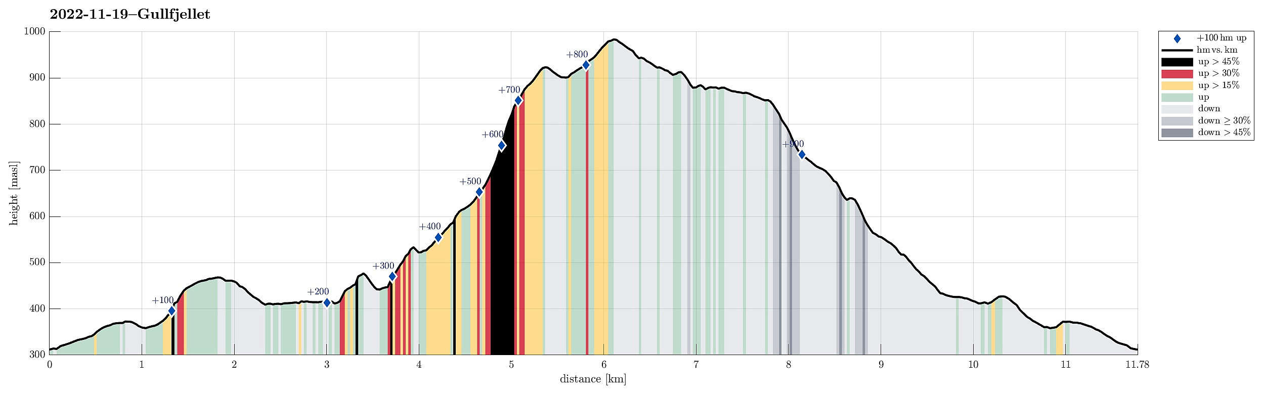
| Tourlänge | 4h 30min |
| Entfernung | 11,8km |
| Höhenmeter | 949m |
| GPS |
|
| Besteigungen | Gullfjelltoppen (987m) | 19.11.2022 |
|---|---|---|
| Ronamanen (889m) | 19.11.2022 | |
| Smetthaugane (482m) | 19.11.2022 | |
| Storegga (926m) | 19.11.2022 | |
| Svartavassrinden (472m) | 19.11.2022 | |
| Besuche anderer PBE | Glamregjelet (625m) | 19.11.2022 |
| Osavatnet p-plass (kr) (310m) | 19.11.2022 |
Trip Summary
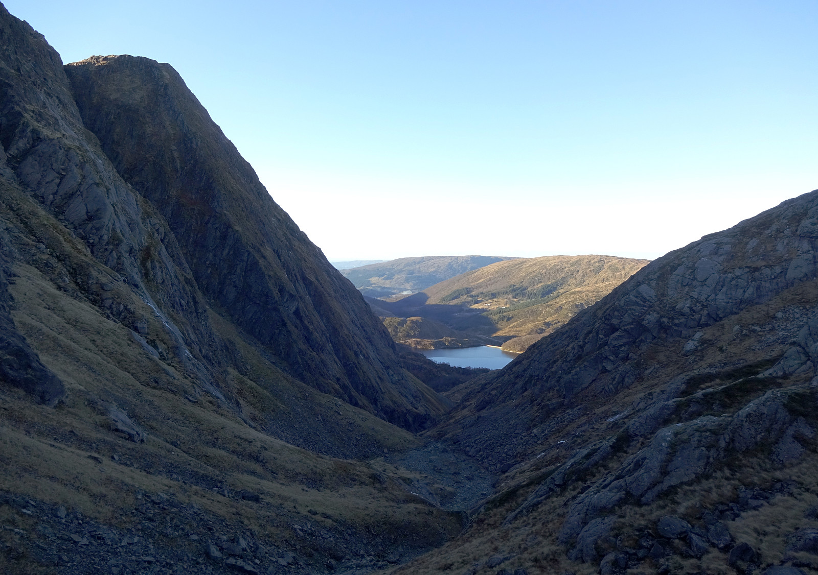
We expected a day with nice weather and decided to use it well. For a while, we had considered to ascend to Gullfjelltoppen via Glamregjelet, i.e., the valley in the northwest of Gullfjelltoppen. Assuming that the condition for exploring this route would be OK, we decided to try it. We started driving up Gullfjellsvegen to park at the parking place next to Osavatnet. From there, we first walked along the gravel road that leads up to the dam of Svartavatnet. Instead of following the "main road", which leads further up to Redningshytten, we took the convenient stairs up on the northern side of the dam, arriving close to the water level of Svartavatnet in the south of Svartavassrinden. While one of the two of us continued "horizontally", following the northwestern shore line of Svartavatnet, the other one of us crossed over the "top" of Svartavassrinden. At the northern-most end of Svartavatnet, where one could continue further northwards into Songstaddalen, we met again, crossing to the other, northeastern side of the lake using the bridge there. Now following the northeastern shore line of Svartavatnet, we headed southeastwards, towards Smettet. Ascending up to Smettet, where the long southern ridge of Hotten comes down, one of us could not resist ascending also to the small "top" of Smetthaugen. Thereafter, the actual adventure started, leaving the proper trail, which continues towards the north, either into Tjørndalen, or up to Hotten. To get around Tjørndalsnipa and enter Glamregjelet, we descended a little from Smettet, mostly southwards, and crossed the stream, which comes down from Tjørndalen. Continuing in the rather flat terrain in the southwest of Tjørndalsnipa, we made it quickly and easily towards the entry point of Glamregjelet. Glamregjelet is a deep valley in the northwest of Gullfjelltoppen with a very steep and tall side on its southern side. From an earlier hike we knew that one needs to stay on the northern side of the stream through Glamregjelet in order to make any progress. South of Tjørndalsnipa, Glamregjelet is also cut deeply into the mountain so that one needs to gain a bit of height over the bottom of the valley in order to proceed further eastwards. About 75 height meters above the entry point into Glamregjelet, the stream at the bottom is flowing around a corner. Even though both sides of the valley are very steep there, one can find a mostly grassy ledge not high above the stream, which allows to continue further inwards without major difficulties. Roughly 100 height meters further up, one then steps "out" into a somewhat more open part of the valley, offering an impressive view up Pilatusgjelet (up to Ronamanen) in southwestern direction. We indeed had chosen a good day, since most water seemingly chose to be rather ice than flowing water, leaving most of the valley without much water. Thus, we could easily continue further upwards, not worrying much about where to avoid the stream. At about 650masl, actually, we climbed through a short, rather narrow part of Glamregjelet, where certainly on other days quite a bit of water can be expected. In retrospect, one could instead try to avoid this section and ascend a bit further towards the south in this part of Glamregjelet. Once approaching 700masl, it became clear that continuing further upwards at the bottom of Glamregjelet, coming steeply down from Gullfjellhalsen there, did not seem possible without actual climbing. Instead, we evaluated it as much more reasonable to continue our ascent via the "ridge" north of Glamregjelet, leading up into the direction of Storegga (in northeastern direction). Even though the terrain is clearly very steep there, stepping up there was still possible without real difficulties. Once at about 850masl, the slope then "flattens" out a little and ascending the last stretch from there to Storegga then is easy again. From there, it was then "only" to surround the little lake at the top end of Glamregjelet on its eastern side and continue further upwards to Gullfjelltoppen from there via Gullfjellhalsen. After a short break near Gullfjelltoppen, we then followed the trail via Midtrinden to Ronamanen, looking down into Pilatusgjelet from above there. Given the sun and the nice day, walking around Ronamanen was really enjoyable. Following the ridge further down (in southwestern direction), we then enjoyed nice views onto Markskiltjørna first and Markskilfossen thereafter. Eventually, we then took the trail out to the gravel road, which leads in northwestern direction between Stuthaugane in the southwest and Småhaugane in the northeast. Between 525masl and 475masl, the trail is now placed on the northern side of the stream. Not long later, we had arrived at the gravel road, coming down from Redningshytten there, which we then followed out to the parking spot. All in all, this hike really turned out very nicely -- an adventure, yes, but well possible given the rather dry condition in Glamregjelet. Nice! :-)
Photos
Selected photos are available as Google photo album.
Useful Resources
See also the related FB-page Hiking around Bergen, Norway.
Petter Bjørstad has a page about Gullfjellet and also web page WestCoastPeaks.com provides useful information about Gullfjellet.


Benutzerkommentare