
Litlagullfjellet (02.02.2020)

Geschrieben von HHauser (Helwig Hauser)

| Startpunkt | Osavatnet parking (315m) |
|---|---|
| Endpunkt | Osavatnet parking (315m) |
| Tourcharakter | Wanderung |
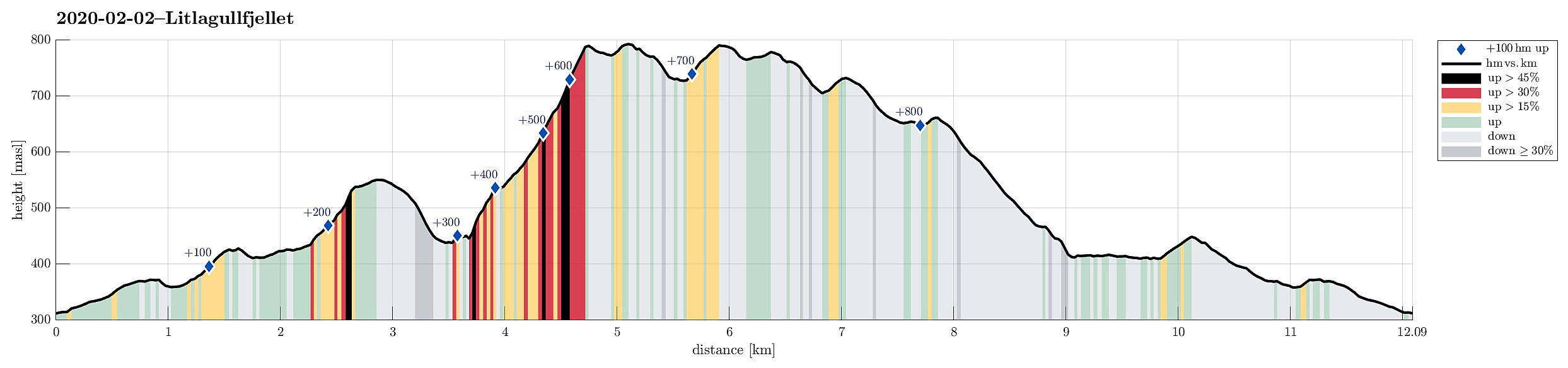
| Tourlänge | 5h 00min |
| Entfernung | 12,1km |
| Höhenmeter | 893m |
| GPS |
|
| Besteigungen | Hotten (668m) | 02.02.2020 |
|---|---|---|
| Høgevarden (781m) | 02.02.2020 | |
| Litlagullfjellet (799m) | 02.02.2020 | |
| Vossavardane, M (793m) | 02.02.2020 | |
| Vossavardane, S-1 for NV (735m) | 02.02.2020 | |
| Besuche anderer PBE | Osavatnet p-plass (kr) (310m) | 02.02.2020 |
Trip Summary
After a longer, relatively wet period, we anticipated a nice Sunday and thus planned "a proper hike"! :-) For a longer time, already, we had thought about visiting Litlagullfjellet, and this day seemed to give a nice opportunity to do it. Litlagullfjellet is part of the Gullfjellet mountains, located northwest of Gullfjelltoppen. It's not so much visited, since Gullfjelltoppen is higher and thus "overshadowing" Litlagullfjellet. Further, you have to plan your hike a little, since "coming by" Litlagullfjellet "accidentally" is rather unlikely (no major trails lead to it, really). Once up there, however, one can enjoy great views, mostly towards the west, making it worthwhile to visit nonetheless! :-)
Approach
We took the car from Bergen, following road 587 into the direction of Arna. Before reaching Haukeland (and Haukelandsvatnet), we turned right (onto the comparably narrow road 5290 towards Unneland). At Unneland, where another minor road joins from the north (road 5292), one enters the valley that leads up towards Osavatnet at about 300mosl. We then parked at the relatively large parking spot north of Osavatnet (40NOK of road toll to get there) and started our hike from there, following the major gravel road that extends towards Svartavatnet from there. Before actually getting to the rather large dam of Svartavatnet, another (also major) gravel road separates to the right (south), heading up into the direction of Redningshytten. At about 425mosl, this road crosses over a little saddle in the southwest of Svartavatnet, offering some nice views over the lake. Further south, where a major stream, coming down from the much higher Markskiltjørna, flows into Svartavatnet, a minor trail is leading away from the gravel road (it starts at about 425mosl, leading in southern / southeastern direction). This brings one down to the stream, which one then has to cross to its northeastern side (this crossing is without any bridge and days with lots of water can make this crossing a bit of a challenge). Once on the other side of the stream, one follows it upwards in southeastern direction. Soon, we left the major stream further below, ascending parallel to a smaller stream. This brings one into a relatively narrow gully, south of Småhaugane. The more direct ascent through this gully, south of the stream, is a bit steep and exposed (especially when covered with snow etc.), which possibly is the reason for the map also showing an alternative route, north of the stream. Once through the gully, one reaches flatter terrain, again, with the main trail turning southwards, leading towards the southwestern ridge of Ronamanen (a great trail up to Gullfjellet!). Since our goal was Litlagullfjellet, instead, we left the trail there, heading in northern direction. This way, we crossed a little saddle, east of Småhaugane, at about 550mosl. The goal was to hike along Rundamansbrekkene and to descend towards a little place, southeast of Smetthaugane, where the waters from Glamregjelet meet those coming down from Tjørndalen. From there, we had planned to ascend Litlagullfjellet, after all! :-)
Ascent
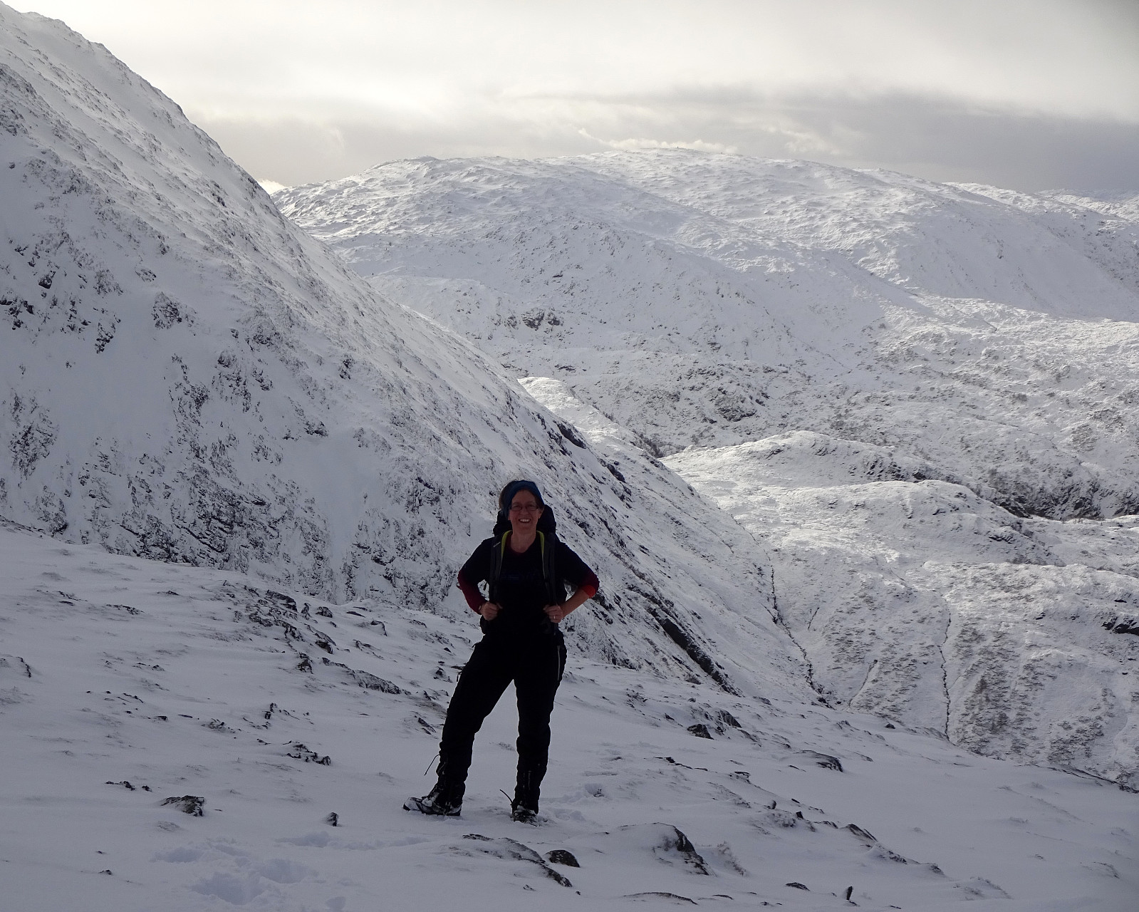
Descending towards the flats underneath Glamregjelet across moderately steep terrain was non-problematic, choosing our steps carefully through the snow. Shortly after, we arrived well 100 height meters further down, checking out the best way to start our ascent up to Litlagullfjellet from there. The original idea, of first getting above the last little step of Glamregjelet in its south, before crossing over to the south of Tjørndalsnipa, proved to be impossible (the mountain side in the south of Glamregjelet, leading up to Ronamanen, is simply too steep and wild). We thus crossed the stream coming down from Glamregjelet in the flat area southwest of Tjørndalsnipa. Since the west-side of Tjørndalsnipa is too steep (at least in snow etc.), we therefore headed into the direction of Glamregjelet (on its northern side, however), ascending diagonally while progressing in eastern direction. Once well on the southern flank of Tjørndalsnipa, it became well possible to ascend more directly (in northern direction). After a bit of stepping upwards, we thereby came to Tjørndalsnipa at about 535mosl, enjoying some nice views from there towards the west (and Svartavatnet). From there, the ascent became more straight-forward (one recognizes that it's going substantially upwards, but it's save and unproblematic of find a suitable route). In order to avoid a gully east of Tjørndalsnipa (with some cliffs etc.), we first ascended long a minor ridge (mostly in northestern direction). As soon as we had come to heights above the gully and its cliffs, on our right-hand side, at about 675mosl, we turned into an eastern direction in order to first ascend to a height south of Litlagullfjellet, which is only a few meters lower than Litlagullfjellet. Already there, we enjoyed some very nice views, mostly in western direction (Gullfjellet in the east was covered with clouds, mostly). Walking over to Litlagullfjellet, now in northern direction, was then quick and simple (one just needs to be ready to break into the snow, not knowing what's below). At Litlagullfjellet, we then looked down into Tjørndalen and over to Hotten, where we wanted to descend, later.
Vossavardane and Hotten
At Litlagullfjellet, we decided to head "directly" towards Vossavardane (instead of including another minor height, northeast of Tjørnane). Following the northeastern ridge of Litlagullfjellet, we thereby came to the place, where a significant lake (the slightly lower one of Tjørnane) empties into Tjørndalen through a narrow opening. Even when nearby, already, we still had difficulties to judge the situation: Was is possible at all to descend over the steep snow (without falling into the lake; the ice and snow on the lake looked like certainly not supporting a person's weight)? Was it possible to step over the water without drowning our hiking boots (with ice-cold water)? After a little back and forth at the upper edge of the rocks, we finally found a spot, where stepping down was possible, making and securing steps in the steep snow. Once down at the water level, we also could step along it for a few meters, before crossing over and ascending again. Definitely a little adventure! :-) The next goal was then Vossavardane (easy and straight-forward). While crossing over Høgevarden, we got engulved by some new snow, but finding our route remained straight-forward and easy. From Høgevarden, we continued in western direction (and down) towards Tjørndalsskaret. Before turning even further (then southwards and into the direction of Hotten), we quickly included the little top southwest of Tjørndalsskaret. From there, then, it was then mostly downwards along a very nice ridge, leading towards Hotten. Hotten is not really a remarkable top by itself, but it's well visible from many sides and one has great views from it, accordingly. From Hotten, we then followed Svartavassrinden downwards (in SSE-direction). All this is nice and enjoyable (nice views etc.), but one should recognize that the very southern end of Svartavassrinden is steeper than what is recommended. Instead, at about 525mosl, one takes a short connection in eastern direction in order to join the trail that stretches through Tjørndalen. This trail then leads comfortably down to Smettet, where one circles around the southern end of Svartavassrinden, descending further towards Svartavatnet. Soon one gets down to only a few meters above the lake level of Svartavatnet at about 400mosl. Then one starts to "walk out" the northwestern side of Svartavatnet (along Svartavasslia). A little bit of patient hiking is necessary to get to the very north of Svartavatnet, where a convenient bridge leads over the waters coming down from Songstaddalen.
Conclusion
From there, a proper trail crosses over a small saddle north of Svartavassrinden at about 450mosl. On the other side, this trail (actually in two variants) leads down to the main gravel road near the dam of Svartavatnet. Once at the gravel road, it's then not far before getting back to the parking lot at Gullfjellsvegen near Osavatnet. Altogether, this hike was definitely a major experience. Stepping several hours through the snow without any trail or steps from others, enjoying the majestic landscape and many great views. Clearly, it was worthwhile to carefully study the map before starting. Then, however, the hike emerged without major difficulties. Nice! :-)
Photos
Selected photos are available as Google photo album.
Useful Resources
See also the related FB-page Hiking around Bergen, Norway.
Web page WestCoastPeaks.com provides another account of ascending to Litlagullfjellet in a similar way.


Benutzerkommentare