
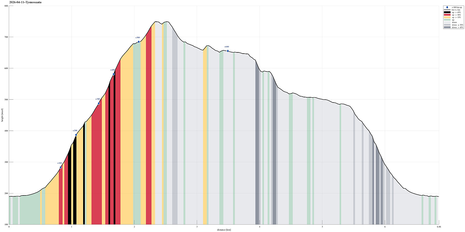
Tysnessåta from Myrdal (11.04.2026)

Skrevet av HHauser (Helwig Hauser)

| Startsted | Myrdal (190moh) |
|---|---|
| Sluttsted | Myrdal (190moh) |
| Turtype | Fottur |
| Turlengde | 3t 45min |
| Distanse | 6,9km |
| Høydemeter | 634m |
| GPS |
|
| Bestigninger | Tysnessåta (752moh) | 11.04.2026 |
|---|---|---|
| Vetlesåta (686moh) | 11.04.2026 | |
| Andre besøkte PBE'er | Tysnessåta - sti fra nordøst (225moh) | 11.04.2026 |
| Tysnessåta parkering (225moh) | 11.04.2026 |
Trip Summary
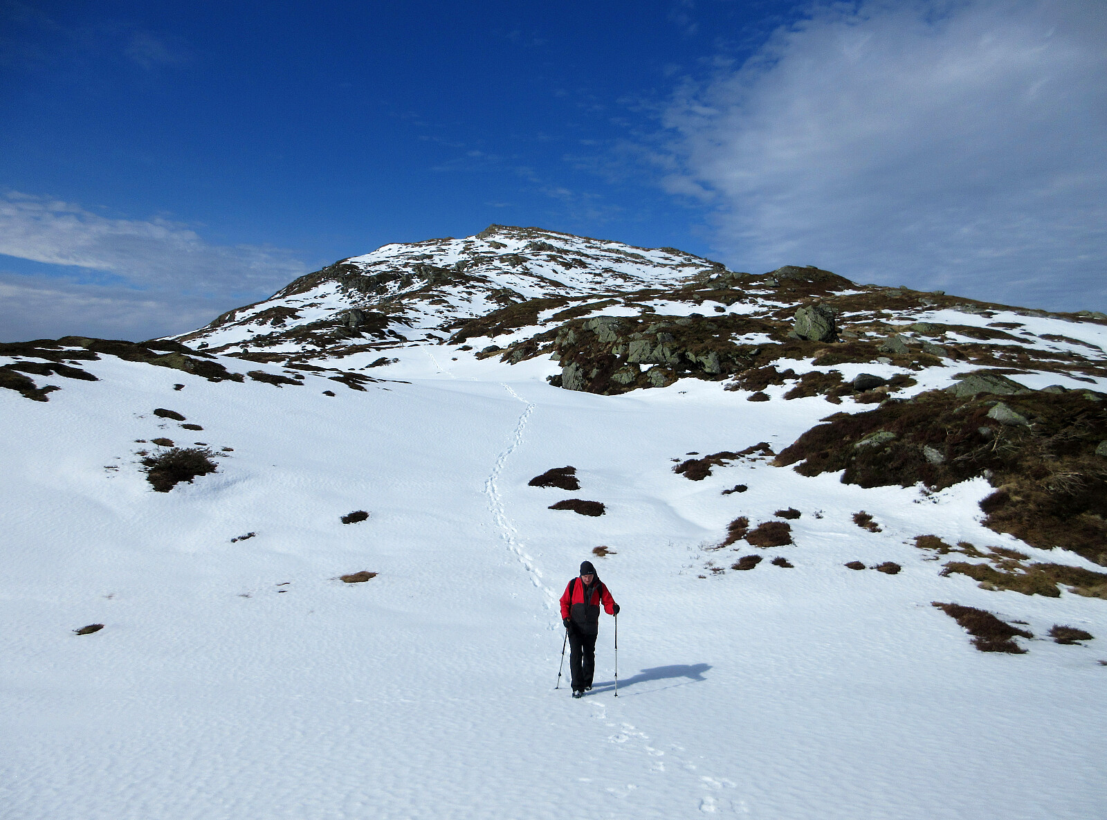
The idea was to make a nice hike on a nice day, which would (1) bring us up to enjoy some nice views and (2) avoid significant amounts of snow, if possible (well, well). We took the ferry from Halhjem to Våge and then drove around and up to Myrdal (already at about 195masl). After parking near Storåkerhølen, a bit north of Myrdal, we started our hike first on a tractor road across Myrdal, before getting into the real hike from the "second" parking place south of Myrdal. From there, one can now (since 2024) find a "Sherpasti" with numerous impressive rock steps that are laid down for large stretches of the ascent along Steinelva. This way, one can "simply" step up these stone steps and reach the heights of Tysnessåta quickly (one still needs to make about 550 height meters, so it's clearly a hike!). For us, we started to face an increasing amount of snow the higher we got; once above about 500 masl, the steps were at times completely covered by snow and ice, requiring a bit of care to not slip. It still did not take us much more than one hour to reach the top. While the weather was nice and the views were great, the wind up at Tysnessåta was very chilly and we did not stay long before continuing. After first descending along the same trail that we just had come up, we then continued across Vetlesåta in southeastern direction. Without any steps in the snow to follow, we could not make progress as quickly as originally thought (at every step, we had to explore whether we would break through the snow, or not). As soon as the terrain drops towards Ådnastegen (then in the east), we decided that we'd just descend into Dalen and then head back towards Myrdal. Descending into Dalen (without a visible trail, with quite some snow around, and in a relatively steep terrain) came with a bit of excitement :-) before we then continued a bit more relaxed back towards Myrdal through Dalen (in Dalen, there wasn't much snow left, but certainly a lot of water). After passing through Dalen, we reconnected with Sherpastien, which we then took down to Myrdal. All in all, this hike was very nice.
Photos
Selected photos are available as Google photo album.
Useful Resources
See also the related FB-page Hiking around Bergen, Norway.
On web page prominent-mountains.no, there's a useful page about Tysnessåta.
Similarly, on web page WestCoastPeaks.com, there's a useful page about Tysnessåta and Veghamrane.


Kommentarer