
Møsnuken from Heggeland and Gjemdalsskaret (06.08.2023)

Skrevet av HHauser (Helwig Hauser)

| Startsted | Heggeland (80moh) |
|---|---|
| Sluttsted | Heggeland (80moh) |
| Turtype | Fottur |
| Turlengde | 3t 00min |
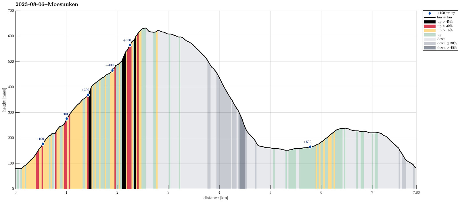
| Distanse | 7,9km |
| Høydemeter | 683m |
| GPS |
|
| Bestigninger | Møsnuken (639moh) | 06.08.2023 |
|---|---|---|
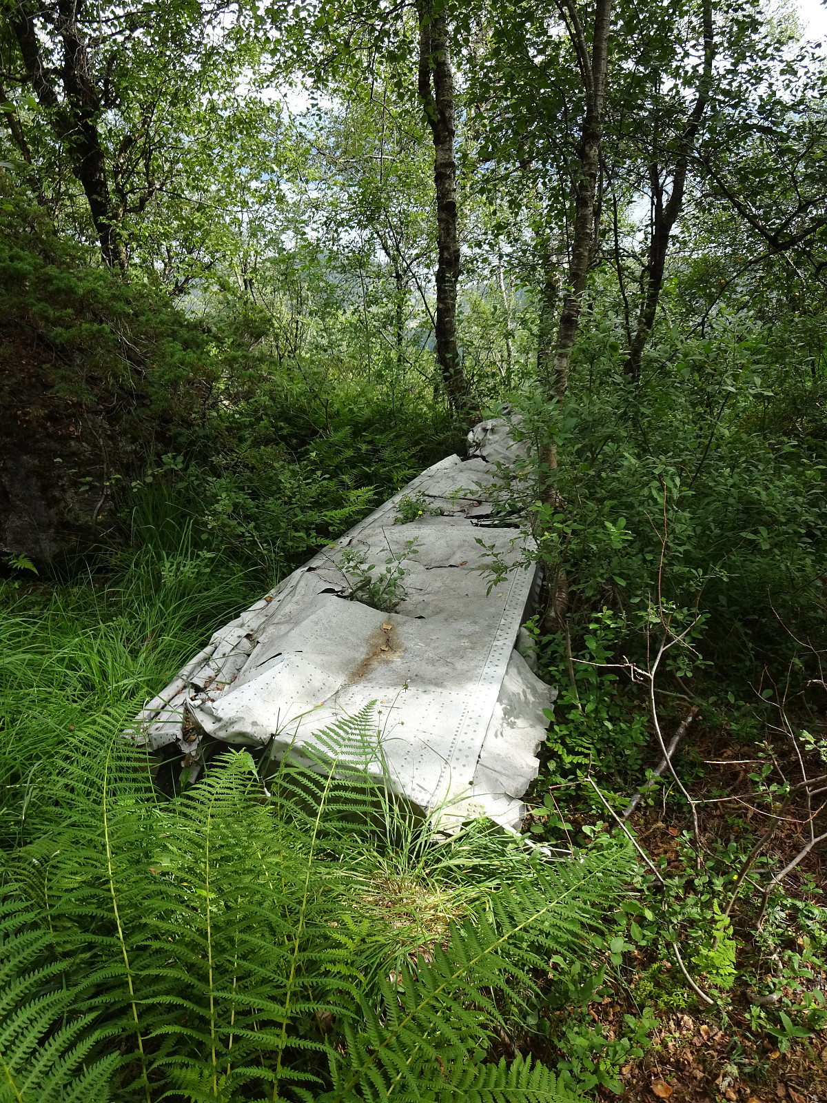
| Andre besøkte PBE'er | Flyvrak - JU88 fra 1942 (401moh) | 06.08.2023 |
Trip Summary
We thought that crossing over Møsnuken from Gjemdal / Heggeland (in the east) to Krokvatnet (in the north) and then returning via Gjemdalsskaret back to the starting point sounded like a nice idea. :-) Accordingly, we took the new E39 connection from Bergen to Osøyro, just to continue into Hegglandsdalen from there (road 579). After passing by Tveitavatnet, we found a place to leave our car (quite near to where Spannsteigselva comes down from Gjemdalsskaret). Instead of following the gravel road up to Gjemdalsskaret from Gjemdal (to then connect to the trail that leads up to Tveitaskaret), we aimed at an ascent route through the forest in the west of Spannsteigselva (without trail). Near house #659 along Hegglandsdalsvegen we stepped onto a simple field road, leading steeply upwards into the direction of Hundhaugen. Near Hundhaugen, we identified a "diagonal" among the trees, leading further upwards in northern direction. Ascending steadily upwards, we stayed first mostly on the eastern side of the mountain (in the west and above of Spannsteigselva). Only after heading (mostly) north for a while, we then turned left (and into the proper forest) at about 220masl. Then heading more west than north, we ascended further upwards (quite straight-forward there and not really difficult) and soon later connected to the trail that one also could have taken from Gjemdalsskaret. We then also came to the place, where one needs to choose between two routes: a lower one (a bit further south) and an upper one (a bit further north). Taking the latter, we ascended some additional 50+ height meters further upwards. Once up there, we soon came by this place where one can still see remains of a crashed German war plane (from WWII) -- the upper one of two of these places, to be more accurate. From there, we then continued along the marked trail into the direction of Tveitaskaret. At the highest point, there, we decided to take a more direct ascent route upwards (than following the marked trail further westwards, first, and then turning back and diagonally upwards from there). Stepping (steeply) upwards there (mostly in northern / northwestern direction) is possible, but requires the use of the hands a few times. After making some additional 70 height meters this way, we reconnected with the trail and took this trail then to the top of Møsnuken. After a short break on Møsnuken, we then headed further north, first visiting "Little Møsnuken" in the north of the main top. Continuing further from there, we crossed over Gjelhaugen (all this continuation northwards from the top of Møsnuken is without a trail, just to note). In the north of Gjelhaugen, one then gets to a sharp "cut" in the landscape, which extends further into Gjelet in the northeast of Gjelhaugen. Since this "cut" is not all too deep, crossing over it (further northwards) is not really a difficulty. From there, the continuation further northwards is actually very nice (but also increasingly steep)! Our goal was to follow this northern ridge of Møsnuken "all the way" to Lægdene (where there is another "cut" across the ridge) and then descend through the valley in the northeast of this second "cut" to the gravel road that comes down from Gjemdalsskaret, leading to Åreiane in the south of Krokvatnet. While first well "en route", we then, however, got diverted towards the east of Lægdene a bit too early, maybe. First, this was just fine, but between about 310masl and 230masl, this descent was very steep, requiring some extra care (and the use of our hands, repeatedly). It all went well, after all, but still it appears better to first follow Lægdene further northwards while still "up on the ridge", avoiding this particular steep descent. As soon as we were further down, in the lower parts of this valley, we found a convenient connection to the gravel road and used this forest road, then, to visit Krokvatnet before turning back. The way back was then nice and easy (just following the forest road up and over Gjemdalsskaret). Once below Høgestølen (on the other, southern side of Gjemdalsskaret), we left the gravel road, again, taking a more direct route down (in parallel to Spannsteigselva -- but now on its other, eastern side), leading us "directly" back to our car. Altogether, this hike was very nice -- especially the traverse over the northern ridge of Møsnuken is very nice! :-)
Photos
Selected photos are available as Google photo album.
Useful Resources
See also the related FB-page Hiking around Bergen, Norway.
Web page WestCoastPeaks.com provides useful information about Møsnuken and Tyssdalsfjellet
and also Petter Bjørstad has a useful page about Møsnuken.


Kommentarer