
Søtefjellet from Hausdalen via Åsen (06.06.2021)

Skrevet av HHauser (Helwig Hauser)

| Startsted | Hausdalsvegen (75moh) |
|---|---|
| Sluttsted | Hausdalsvegen (75moh) |
| Turtype | Fottur |
| Turlengde | 5t 30min |
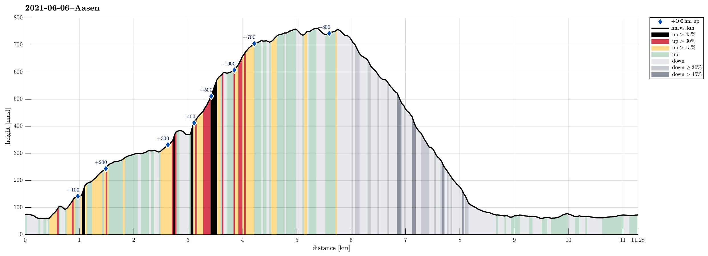
| Distanse | 11,3km |
| Høydemeter | 870m |
| GPS |
|
| Bestigninger | Søtefjellet (767moh) | 06.06.2021 |
|---|---|---|
| Søtefjellet NV (762moh) | 06.06.2021 | |
| Åsen i Samdalen (389moh) | 06.06.2021 | |
| Andre besøkte PBE'er | Åsen søyle (385moh) | 06.06.2021 |
Trip Summary
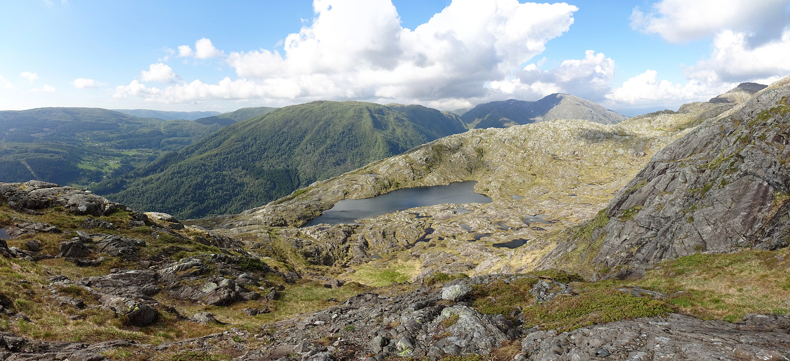
With the promise of a nice afternoon ahead of us and knowing the days are long during the Norwegian summer, we headed for Hausdalen and a hike that we had thought about for quite a while (it had to wait for the right day!). The main idea was to start in Samdalen (a long way into Hausdalen) and then hike to Åsen first (a kind of smallish hill that nonetheless peaks out from its exposed position at the junction of Hausdalen and Brekkjedalen). From there, the idea was to attempt an ascent to Søtefjellet, from where we knew that it was straight-forward to hike down along the long ridge that leads in southwestern direction towards Ulvvatnet. After driving into Hausdalen from the very south of Kalandsvatnet (along E39 in the south of Bergen), we found a suitable place right next to the road, where we could leave the car. We then crossed the flat bottom of Samdalen along a field road that brought us to Samdalselva. A few meters further north from where we had come close to Samdalselva, we crossed the river on a nice bridge. From the other side of the bridge, we ascended (gently) in southeastern direction to connect to the southern ridge of Bjørhaugen. The small intermediate plan was to check out Tømmerdalsfossen. Given the relatively dry period, the past few days, this water fall was not very spectaculy, however, and we continued basically without stopping to our next goal, i.e., to get up to the long southwestern ridge that we then wished to walk up to Åsen. Basically right next to the "top" of Bjørkhaugen, we then found an opportunity for getting up to the ridge (it's steep there, but ascending was still well possible). Once on the ridge, we enjoyed a very nice walk towards Åsen, offering great views across Hausdalen more or less all the way. At the very end of this ridge, right in the west of Åsen, we then needed to find a way of how to get up to Åsen. While the terrain is steep there, this still proved to be well possible (at times, however, we needed to get a bit of help from our hands). A few minutes later, we found ourselves at the top of Åsen, confirming that it clearly is a place that is worthwhile visiting. After enjoying the views from Åsen, we then continued to try our little ascent-adventure (to Søtefjellet). Getting down from Åsen (on its eastern side, towards the saddle) was without difficulties (we used our hands, again, though). The first part, right from the saddle upwards, however, is a little bit challenging (significantly steep and repeatedly it was necessary to get help from the hands, also here). After crossing over the first 50 height meters, or so, however, we found the terrain to be less challenging (as expected, also, from our map study at home). While still steep, it was then well possible to step up (mostly in southern direction, following a partially diagonal route across the mountain side there). Even though we had to aim without actually seeing our target, until we had come very close already, we still made it more or less perfectly towards a nice little lake that is located between Søtefjellet and Åsen at almost 600mosl. And what a lovely place this is! Clearly, there was no other option than to spend quite a bit of quality time right at the side of this lake, enjoying the nice weather and the lovely mountain scenery. :-) After this wonderful break, we continued further southwards and into the direction of Søtefjellet. We then ascended first towards the northwestern side-peak of Søtefjellet, where also the county border between Bergen and Os (Bjørnafjorden) lies, before including the actual Søtefjellet by making a little extra round. After completing this littla extra round, we then started our descend along the long ridge that eventually leads down to Ulvvatnet. On our way there, however, we had to enjoy lovely views across Hausdalen from several exposed places along this ridge. Very nice indeed! At the lower part of this ridge, one also find a proper trail, which is straight-forward to follow (with a few steep sections, but without problems). Once down (to Hisbotnen), the trail levels out and one passes by Ulvvatnet (first) and Samdalsvatnet. (thereafter). Soon after, we were back on the road through Hausdalen and walking back to the car did not take long, then, neither. All in all, this really was a wonderful hike, with a beautiful stop at this lake right above Åsen. One needs to consider, however, that ascending to this lake from Åsen requires a bit of hiking experience (and a bit of stamina, also).
Photos
Selected photos are available as Google photo album.
Useful Resources
See also the related FB-page Hiking around Bergen, Norway.
Petter Bjørstad has a useful page about Søtefjellet and also web page WestCoastPeaks.com provides useful information about Sveningen, Søtefjellet, Sauskolten, Rindafjellet, and Midtsæterfjellet.


Kommentarer