
Ulriken from Haukeland Hospital (stone steps up) (20.04.2019)

Skrevet av HHauser (Helwig Hauser)

| Startsted | Haukeland Hospital (45moh) |
|---|---|
| Sluttsted | Haukeland Hospital (45moh) |
| Turtype | Fjelltur |
| Turlengde | 3t 00min |
| Distanse | 7,1km |
| Høydemeter | 614m |
| GPS |
|
| Bestigninger | Lægdetjerntoppen (601moh) | 20.04.2019 |
|---|---|---|
| Ulriken Vest (607moh) | 20.04.2019 | |
| Andre besøkte PBE'er | Breidablik (583moh) | 20.04.2019 |
| Fjellsol (585moh) | 20.04.2019 | |
| Lorthaughytten (ruin) (570moh) | 20.04.2019 | |
| Nødkjelke, Oppstemten (442moh) | 20.04.2019 | |
| Ravnegrind (228moh) | 20.04.2019 | |
| Stormfuglen (592moh) | 20.04.2019 |

Trip Summary
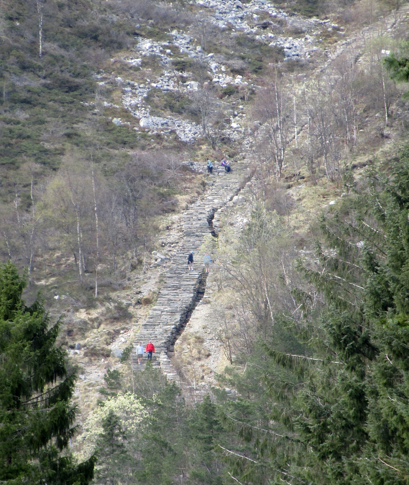
We started from a bus stop at Haukeland University Hospital and first walked up the street to the lower station of the cable car that goes up to the top of Ulriken. Instead of taking the cable car, however, we followed a trail that leads up to Montana (and from there further towards Ulriken etc.). Once above the Montana Vandrerhjem, we followed the gravel road Johan Blytts vei, which ascends diagonally in southeastern direction, before it crosses a little stream. From there, it's getting steeper and shortly after, a renewed path turns left (from there then steeply upwards in northeastern direction). Before eventually departing from the gravel road (near Hellerane), the path gets once again very near to it (at about 325mosl). From there onward, it then goes steeply upwards (through Lægdebotn and over recently placed stone steps). Impressive, what this path turned into! After the ascent, we arrived directly at the top station of the cable car and enjoyed a little rest and some refreshments at the small restaurant that visitors find up there. We then decided to also walk down (instead of taking the cable car) and did so by first following the heights of Ulriken in southern direction (coming by Lægdetjernet, for example). This way, we came to Landåseggen, which we hiked down then. At about 450mosl, this path turns right (and into northwestern direction). Soon after, one then connects to the gravel road that comes up from Montana. From there onward, we basically followed the same way down that we had used up in the beginning. Certainly a nice and rewarding hike! :-)
Photos
Selected photos are available as Google photo album.
Useful Resources
See also the related FB-page Hiking around Bergen, Norway.
Web page WestCoastPeaks.com provides useful information about Haugavarden, Ulriken, Storfjellet, and Landåsfjellet and also Petter Bjørstad has a useful page about Ulriken.
Web page UT.no from the Norwegian Trekking Association recommends a similar hike up to Ulriken.
On Bergentopp 200 there is a page (in Norwegian) about Ulriken.


Kommentarer