Arkiv - dato
Arkiv - aktivitet
-
Annen vintertur (3)
- Trugetur (3)
- Fottur (137)
-
Kjøretur (1)
- Biltur (1)
-
Klatring (23)
- Alpin klatring (9)
- Sportsklatring (11)
- Via ferrata (2)
-
Skitur (62)
- Fjellskitur (3)
- Langrennstur (1)
- Randonnée/Telemark (58)


Lister jeg samler etter
-
Norges 1000 største fjell målt i primærfaktor
(45/1000)
 4%
4%

Favoritturer
Favorittopper


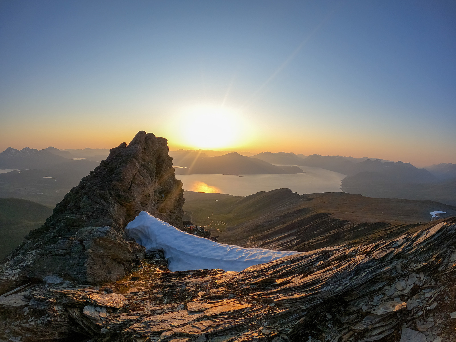
Vasskartinden
- Dato:
- 30.07.2021
- Turtype:
- Fjelltur
- Turlengde:
- 3:59t
- Distanse:
- 9,4km
 Fjelltopper over 1000m på Norske øyer
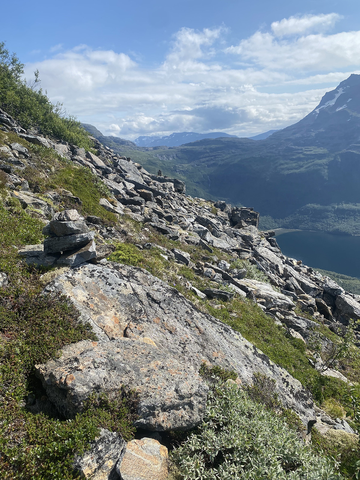
Skulle egentlig ta en kort, rolig løpetur i dag, men våknet til mer sol enn var meldt. Bestemte meg for å prøve Vasskartinden, og etter litt research viste det seg at turen kommer til å foregå i ganske treigt terreng.
Jeg kjørte av hovedveien etter Vasskaret skiltet, og kjørt videre opp grusveien før jeg ankom en gård rett under fjellet. Her var det masse gamle biler og en traktorvei som gikk rett inn mot Vasskartinden. Parkerte bilen her og fulgte traktorveien, først klarte jeg å løpe inn til selve huset på gården før jeg skjønte at det ikke var dit jeg skulle. Løpte deretter ut igjen, og siktet meg mot fjellet. I følge Norgeskart er det sti her, men jeg fant knapt tegn på mennesker. Det var bare å traske opp i bratt overgrodd terreng, >>>
Fjelltopper over 1000m på Norske øyer
Skulle egentlig ta en kort, rolig løpetur i dag, men våknet til mer sol enn var meldt. Bestemte meg for å prøve Vasskartinden, og etter litt research viste det seg at turen kommer til å foregå i ganske treigt terreng.
Jeg kjørte av hovedveien etter Vasskaret skiltet, og kjørt videre opp grusveien før jeg ankom en gård rett under fjellet. Her var det masse gamle biler og en traktorvei som gikk rett inn mot Vasskartinden. Parkerte bilen her og fulgte traktorveien, først klarte jeg å løpe inn til selve huset på gården før jeg skjønte at det ikke var dit jeg skulle. Løpte deretter ut igjen, og siktet meg mot fjellet. I følge Norgeskart er det sti her, men jeg fant knapt tegn på mennesker. Det var bare å traske opp i bratt overgrodd terreng, >>>
Snøtinden
- Dato:
- 29.07.2021
- Turtype:
- Fjelltur
- Turlengde:
- 4:00t
- Distanse:
- 15,3km
 Fjelltopper over 1000m på Norske øyer
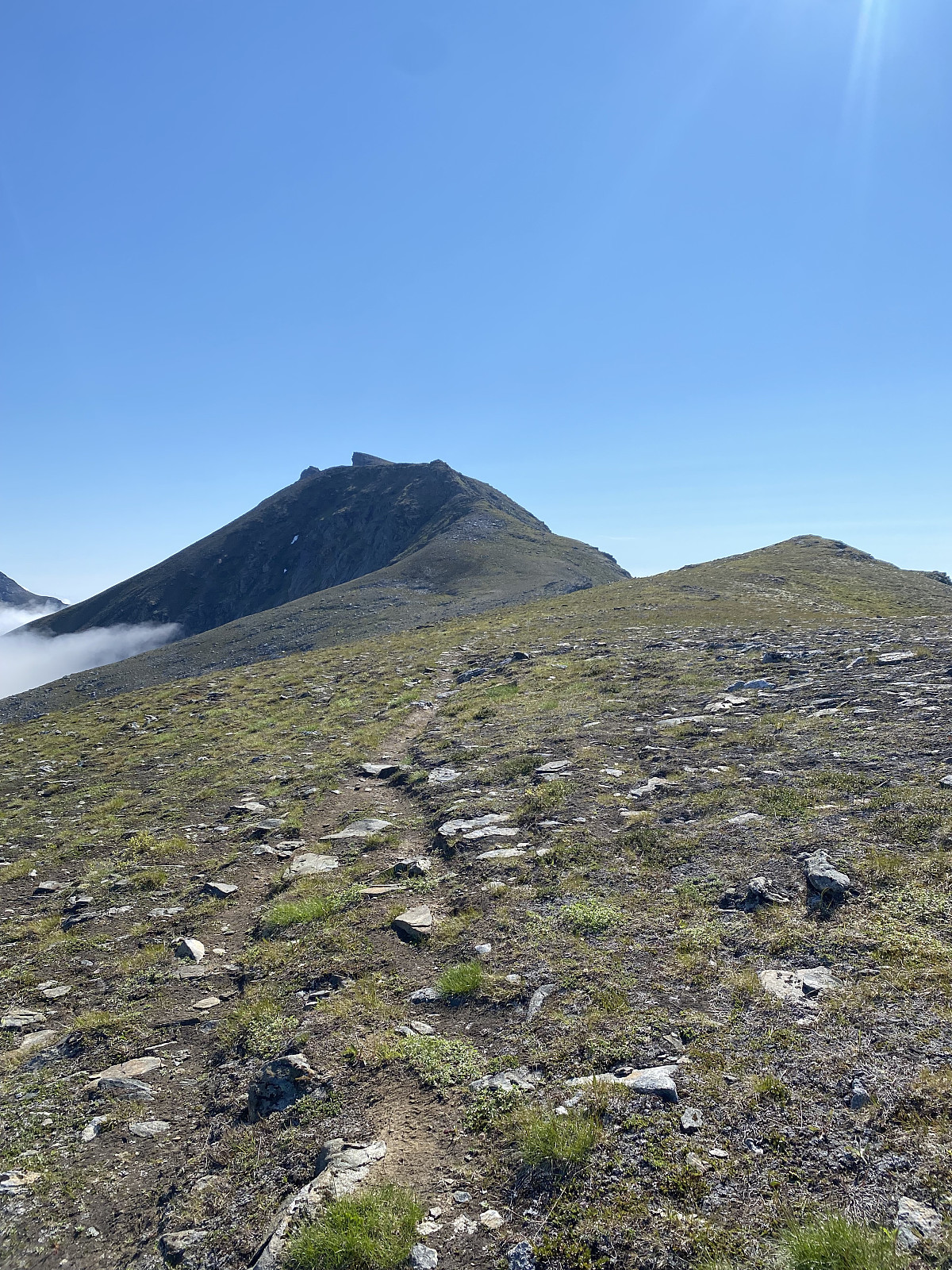
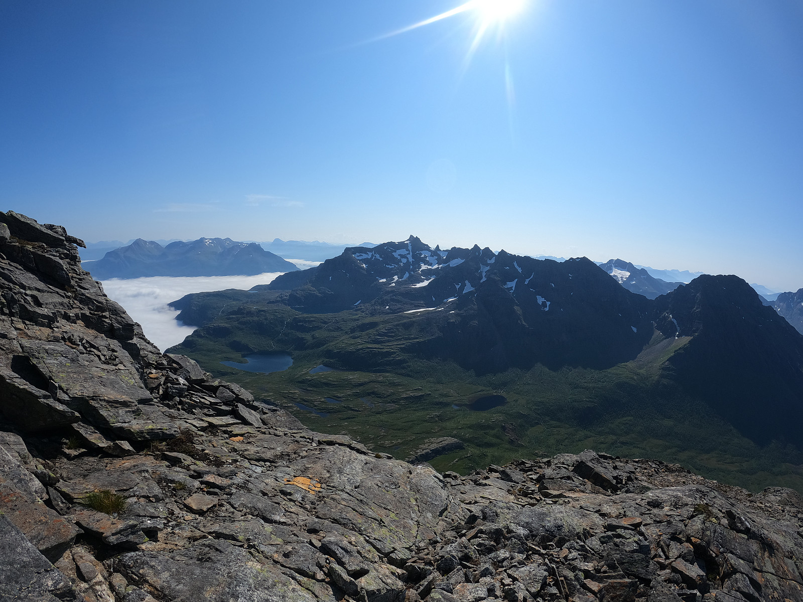
Etter jeg parkerte bilen ved veiens ende i Ånstad (Munnhågen?) fulgte jeg grusveien og etter hvert en godt markert, upåklagelig sti videre inn i dalen mot Stillelva. Fra stillelva fulgte jeg skilting mot Måsan. Her var stien av litt dårligere kvalitet, men fortsatt tydelig og godt markert. Når man ankommer postkassen Måsan, svinger man i nordlig retning over en liten hump før man får sitt første blikk mot de siste 500 høydemeterne opp Snøtinden. Her oppe var det utrolig fint, med nydelig utsikt over fjorden til fastlandet og rolla, samt mot Ristinden og Åtinden (som begge to fortsatt er på listen).
Herifra var det sporadisk sti etter sau, men det var ikke vits å følge disse og jeg siktet meg mot den renna midt på fjellet. Terrenget ble >>>
Fjelltopper over 1000m på Norske øyer
Etter jeg parkerte bilen ved veiens ende i Ånstad (Munnhågen?) fulgte jeg grusveien og etter hvert en godt markert, upåklagelig sti videre inn i dalen mot Stillelva. Fra stillelva fulgte jeg skilting mot Måsan. Her var stien av litt dårligere kvalitet, men fortsatt tydelig og godt markert. Når man ankommer postkassen Måsan, svinger man i nordlig retning over en liten hump før man får sitt første blikk mot de siste 500 høydemeterne opp Snøtinden. Her oppe var det utrolig fint, med nydelig utsikt over fjorden til fastlandet og rolla, samt mot Ristinden og Åtinden (som begge to fortsatt er på listen).
Herifra var det sporadisk sti etter sau, men det var ikke vits å følge disse og jeg siktet meg mot den renna midt på fjellet. Terrenget ble >>>
Åtinden Nordre/Kråktinden
- Dato:
- 29.07.2021
- Turtype:
- Løpetur
- Turlengde:
- 2:48t
- Distanse:
- 16,0km
 Jeg parkerte langs grusveien der stien starter. Turen min ble litt kortere enn det står på skiltene, og jeg møtte ganske mange kuer langs veien, så jeg lurer på om man burde ha parkert bilen litt tidligere.
Fulgte en veldig bra og godt markert sti opp til Middagsheia, der turen til Kråktinden/Åtinden nordre fortsetter videre. Her er det en kjempegod og tydelig sti, markert med korte brøytestikker. Fra middagsheia får man en del kilometer på lettgått/lettløpt terreng før man etter hvert kommer til et kort parti med litt klyving, før man kommer opp på den siste delen av ryggen der man har god sikt mot toppen. Hadde lyst å komme meg over til Åtinden midtre og Åtinden, men det stupet så ut som det var rimelig høy sjans for at jeg skulle dø, så de får heller venter. Finfin >>>
Jeg parkerte langs grusveien der stien starter. Turen min ble litt kortere enn det står på skiltene, og jeg møtte ganske mange kuer langs veien, så jeg lurer på om man burde ha parkert bilen litt tidligere.
Fulgte en veldig bra og godt markert sti opp til Middagsheia, der turen til Kråktinden/Åtinden nordre fortsetter videre. Her er det en kjempegod og tydelig sti, markert med korte brøytestikker. Fra middagsheia får man en del kilometer på lettgått/lettløpt terreng før man etter hvert kommer til et kort parti med litt klyving, før man kommer opp på den siste delen av ryggen der man har god sikt mot toppen. Hadde lyst å komme meg over til Åtinden midtre og Åtinden, men det stupet så ut som det var rimelig høy sjans for at jeg skulle dø, så de får heller venter. Finfin >>>
Årbostadtinden
- Dato:
- 28.07.2021
- Turtype:
- Løpetur
- Turlengde:
- 2:23t
- Distanse:
- 10,6km
 Lenge siden jeg sist var på Andørja :)
Parkerte ved en parkeringsplass rett etter Årbostad skiltet. Fulgte traktorveien og røde merkinger et stykke, før stien ble etter hvert smalere og brattere opp gjennom skogen. Over skoggrensen ble utsikten kjempefin mot Senja. Stien var tydelig og det har vært bygd ganske mange varder på veien oppover. Det ble etterhvert mer stein, men turen var fortsatt veldig lettgått. Returnerte via den berømte snø renna som dessverre var helt snøfritt. Dette var ikke det beste valget, og spart definitivt ikke noe tid på det. Badet i elven på veien nedover.
En fin tur, og på tide med litt samling av fjell over 1000m på norske øyer igjen :)
Lenge siden jeg sist var på Andørja :)
Parkerte ved en parkeringsplass rett etter Årbostad skiltet. Fulgte traktorveien og røde merkinger et stykke, før stien ble etter hvert smalere og brattere opp gjennom skogen. Over skoggrensen ble utsikten kjempefin mot Senja. Stien var tydelig og det har vært bygd ganske mange varder på veien oppover. Det ble etterhvert mer stein, men turen var fortsatt veldig lettgått. Returnerte via den berømte snø renna som dessverre var helt snøfritt. Dette var ikke det beste valget, og spart definitivt ikke noe tid på det. Badet i elven på veien nedover.
En fin tur, og på tide med litt samling av fjell over 1000m på norske øyer igjen :)
Rakeltinden
- Dato:
- 27.07.2021
- Turtype:
- Løpetur
- Turlengde:
- 2:30t
- Distanse:
- 11,4km
 Etter 84 år uten sol, fikk vi endelig litt fint vær i nord. Rakeltinden var en overraskende fin tur, og jeg fikk nyte kveldssolen hele turen.
Man sparer noen km og noen høydemeter med å kjøre først inn på en grusvei like etter Markenes. Herifra fulgte jeg grusveien et lite stykke, før stien gikk over til en traktor sti og etter hvert en smalere skogsti. Her kunne resten av Tromsø kommune lært noe om markeringer, det var nesten i overkant hvor ofte man så en rød markering. Stien krysset etter hvert et myrområde, før man kom over skoggrensen. Her var stien fin og utsikten nydelig både opp mot toppen og tilbake over fjorden. Det var ingen måte man kunne gå seg vil her, og turen må nok være en av det mest lettgått topper over 1000m som jeg har vært på?
Vel oppe på toppen var >>>
Etter 84 år uten sol, fikk vi endelig litt fint vær i nord. Rakeltinden var en overraskende fin tur, og jeg fikk nyte kveldssolen hele turen.
Man sparer noen km og noen høydemeter med å kjøre først inn på en grusvei like etter Markenes. Herifra fulgte jeg grusveien et lite stykke, før stien gikk over til en traktor sti og etter hvert en smalere skogsti. Her kunne resten av Tromsø kommune lært noe om markeringer, det var nesten i overkant hvor ofte man så en rød markering. Stien krysset etter hvert et myrområde, før man kom over skoggrensen. Her var stien fin og utsikten nydelig både opp mot toppen og tilbake over fjorden. Det var ingen måte man kunne gå seg vil her, og turen må nok være en av det mest lettgått topper over 1000m som jeg har vært på?
Vel oppe på toppen var >>>
Nysnø i Juli
- Dato:
- 20.07.2021
- Turtype:
- Løpetur
- Turlengde:
- 2:00t
- Distanse:
- 16,6km
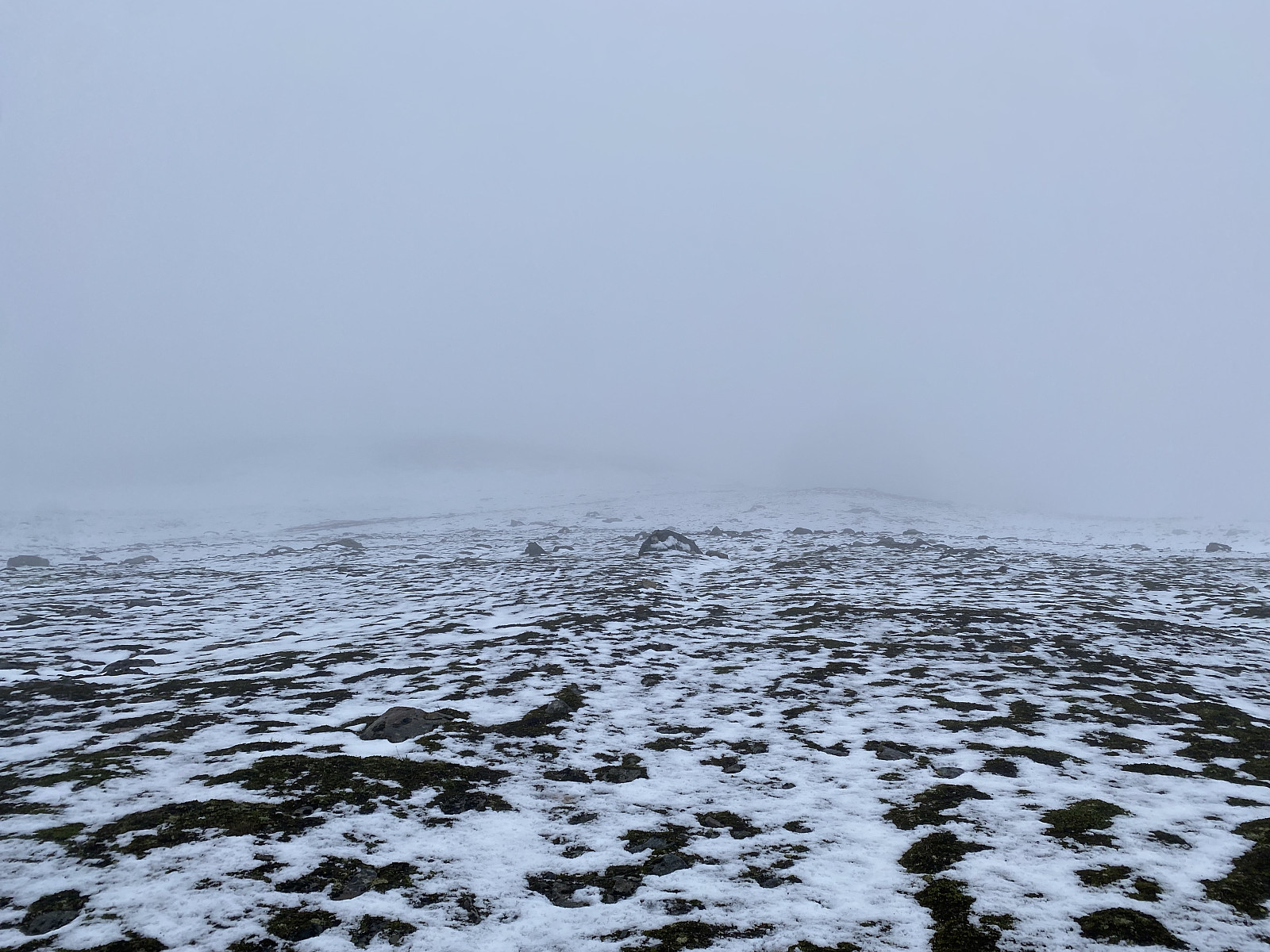 6.5 grader i snitt i dag, som er tydeligvis det kaldeste temperaturmåling i over 100år. Det var ikke gøy kombinert med liten kuling og masse regn. Folketomt på fjellet i hvert fall!

