Arkiv - dato
Arkiv - aktivitet
-
Annen tur (1)
- Kajakkpadling (1)
-
Annen vintertur (4)
- Trugetur (4)
- Fottur (740)
-
Skitur (4)
- Fjellskitur (4)
-
Sykkeltur (137)
- Blandet sykling (51)
- Gatesykling (9)
Arkiv - Etter geografi
"Peakbookvenner"


Lister jeg samler etter
-
Bergen ≥ 50m pf. og ≥ 100 m.o.h.
(87/89)
 97%
97% -
Most dominating tops of the Bergen peninsula
(68/75)
90%
-
Utvalgte topper og turmål i Bergen
(316/350)
90%
-
Alle topper i Bergen
(357/398)
89%
-
Opptur Bergen
(100/113)
88%
-
De syv fjell rundt Bergen
(6/7)
85%
-
Sund ≥ 50m pf.
(14/18)
77%
-
Os ≥ 50m pf.
(25/34)
73%
-
Søyler (fastmerker) i Bergen
(68/100)
68%
-
Fjell ≥ 50m pf.
(21/32)
65%

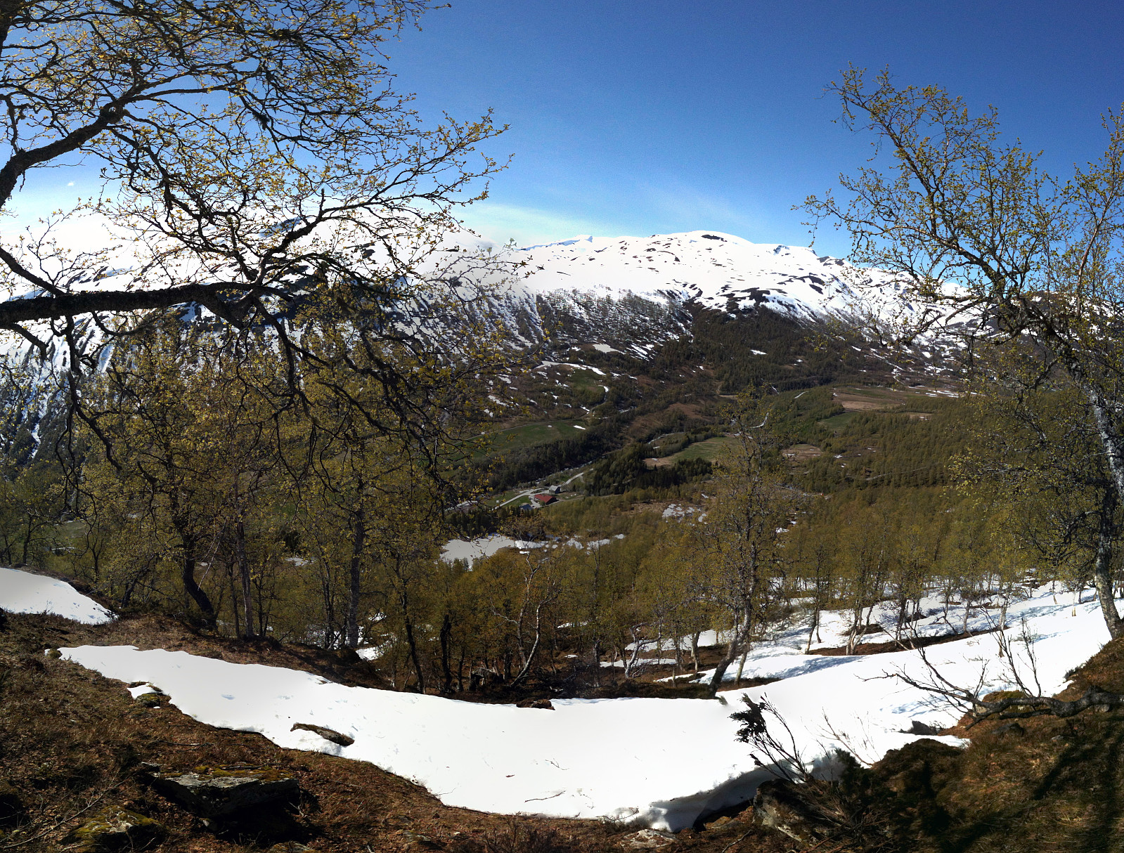
Kristinuten
- Dato:
- 16.05.2016
- Turtype:
- Fjelltur
- Turlengde:
- 4:00t
- Distanse:
- 8,3km
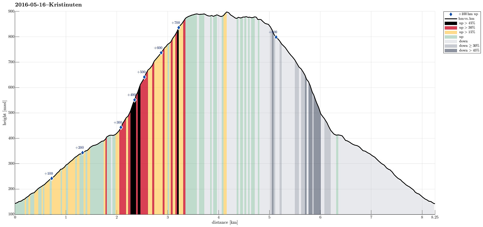 We started from the road between Ulvik and Osa, driving basically to the top of the saddle (between Ulvikafjorden and Osafjorden). There, we continued a little bit further on a side road the passes by Øydve. When getting close to the forrest, we parked and started hiking. The first 300 height meters are convenient on a forrest road that winds back and forth towards Liastølane. Then, one needs to pay attention. A sign ("Kleppe", I think) tells to leave the forrest road and continue along a minor path. This trail is really hard to find---the best tip is to look out for small stones that mark the path. One first ascends further through the forrest before reaching the tree line very soon. From there, it is basically straight up to the top of Kristinuten. It is recommended to >>>
Oksen
- Dato:
- 15.05.2016
- Turtype:
- Fjelltur
- Turlengde:
- 5:00t
- Distanse:
- 9,3km
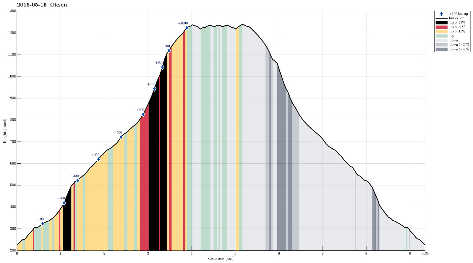 We drove the beautiful road no. 7 into Hardangerfjorden. At Granvin, we connected to the road that comes down from Voss, turning right (into the direction of the new Hardanger-bridge and Ulvik, etc.). We passed the long tunnel (about 8 km), continued towards Ulvik (not up to the bridge) and turned right into a small road right after the tunnel (this place is not completely obvious and paying a little extra attention right after the tunnel helps). From there, we drove (in a way back ) all the way out to the tip of the peninsula on which Oksen is the last mountain. The end of the road (and the starting point for hiking) is Tjoflot. There, one can drive a bit up (passing the farms there) and find a parking spot right after entering the forrest. From there (at about 230 meters over the sea >>>
Birje
- Dato:
- 19.09.2015
- Turtype:
- Spasertur
- Turlengde:
- 3:00t
- Distanse:
- 12,9km
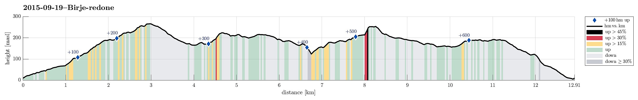 Starting from a place near Øydvenstod, I first followed Osavegen up to the saddle towards Ulvik. There, I turned left, westwards, and ascended the few meters up to Håheim. From there, I followed the marked path -- in southwestern direction -- in order to get up to Åsen. It's not so clear, where the top actually is -- Åsen is well-covered with a forest and there are a number of ups and downs. I found my way to the antenna that is also seen from Ulvik and from there, via a simple path, down to Vattatveit. From there, I first followed the forest road, but when it turned left -- in eastwards directions -- I left it (to the right) and crossed Trånemyrhaugen (basically without any path). I crossed another forest road and continued (without path), this time up Vetlefurehaugen. On the other >>>
Hetta from Fyre
- Dato:
- 21.06.2015
- Turtype:
- Fjelltur
- Turlengde:
- 4:00t
- Distanse:
- 8,3km
 We left our car at the E16, right next to the bridge, which leads to Fyre. There is also a pointer towards Grindaflethytta (along a marked hiking path). Around Fyre, we first walked on a farming road, before we followed the sign that lead us to the left and up (primarily following the main path towards Grindflethytta). After a short distance, the path turns left, before it then, at about 400masl, turns right again. Exactly in this other turn, we continued northwards on what previously was a forest road (we basically walked the whole forest road in between numerous young and small trees that had started to grow on this road -- seemingly not used to often! :-)). We followed this road until it ends right next to a stream that comes down Trolladalen, separating Stalheimsnipa (on the other, >>>
Bont from Jordalen
- Dato:
- 20.06.2015
- Turtype:
- Fjelltur
- Turlengde:
- 2:00t
- Distanse:
- 3,4km
 Leaving Nærøydalen (just underneath Stalheim) to the north, we entered Jordalen through the steep, narrow and slippery tunnels that lead from about 130m above sealevel (in Nærøydalen) up to Jordalen (on about 420masl) -- quite impressive to start with! :-)
We then drove up to the first farm on the eastern side of the valley (at about 520masl).
From there, we first followed a forest path, leading gently upwards in a northeastern direction. We crossed a fence and then ascended (more or less following the steepest possible path) towards the east, later more towards SE. We passed a place that is called Bont (almost flat), before we continued towards Fossaholena. All in all, we did not get up to significant heights -- instead, we met an increasing amount of snow and since we did not have >>>
Leaving Nærøydalen (just underneath Stalheim) to the north, we entered Jordalen through the steep, narrow and slippery tunnels that lead from about 130m above sealevel (in Nærøydalen) up to Jordalen (on about 420masl) -- quite impressive to start with! :-)
We then drove up to the first farm on the eastern side of the valley (at about 520masl).
From there, we first followed a forest path, leading gently upwards in a northeastern direction. We crossed a fence and then ascended (more or less following the steepest possible path) towards the east, later more towards SE. We passed a place that is called Bont (almost flat), before we continued towards Fossaholena. All in all, we did not get up to significant heights -- instead, we met an increasing amount of snow and since we did not have >>>
Sendedalen (Vikafjellet)
- Dato:
- 03.04.2015
- Turtype:
- Fjellskitur
- Turlengde:
- 5:00t
- Distanse:
- 14,2km
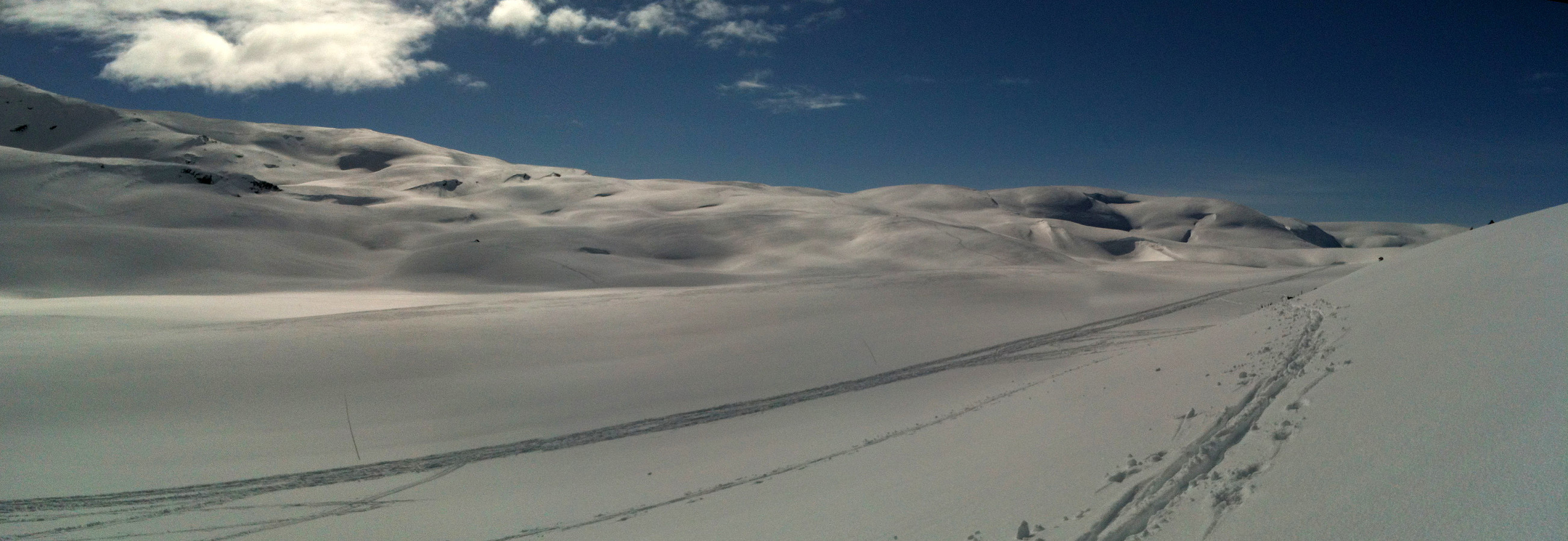 Starting from the road over Vikafjellet (#13), we skied into Sendedalen (and over to Grøndalen) and then back again. What a fantastic winter day?!!! A really great Easter skiing tour! :-)
Selected photos are available as Google photo album .
Starting from the road over Vikafjellet (#13), we skied into Sendedalen (and over to Grøndalen) and then back again. What a fantastic winter day?!!! A really great Easter skiing tour! :-)
Selected photos are available as Google photo album .
Grindaflethytta
- Dato:
- 23.07.2014
- Turtype:
- Fottur
- Turlengde:
- 15:00t
- Distanse:
- 43,7km
 Two days tour from Ljosanbotn (arrival with the train from Bergen) -- first day to Grindflethytta (via a really well marked trail, including three summer bridges); then, next day, first along the marked trail towards Fyre (up to the pass near Stangahøgdi, where the trail starts to descend into Øvsthusdalen), before then following the ridge up to Kaldanuten (no trail along this part) and then down (via Bjørndalsvatnet) into Bjørndalen and out to Brandset. An intense hike, alltogether: about 42km and about 15h out in the beautiful nature.
Selected photos are available as Google photo album .
Two days tour from Ljosanbotn (arrival with the train from Bergen) -- first day to Grindflethytta (via a really well marked trail, including three summer bridges); then, next day, first along the marked trail towards Fyre (up to the pass near Stangahøgdi, where the trail starts to descend into Øvsthusdalen), before then following the ridge up to Kaldanuten (no trail along this part) and then down (via Bjørndalsvatnet) into Bjørndalen and out to Brandset. An intense hike, alltogether: about 42km and about 15h out in the beautiful nature.
Selected photos are available as Google photo album .
Oksen
- Dato:
- 19.07.2014
- Turtype:
- Fjelltur
- Turlengde:
- 4:00t
- Distanse:
- 10,2km
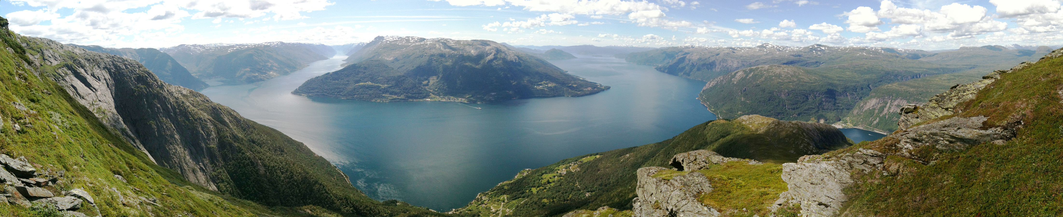 Beautiful tour up and down Oksen -- in fantastic summer weather! :-) We started from the parking place right above Tjoflot (at about 200m above the fjord) and took the (nice!) path via Vindhovden up to Oksen (we made the top, roughly 1000m above the parking place, after about 100mins.). We then continued to Veten and enjoyed the views and a break there! :-) Then back to Tjoflot, more or less the same path.
Selected photos are available as Google photo album .
Beautiful tour up and down Oksen -- in fantastic summer weather! :-) We started from the parking place right above Tjoflot (at about 200m above the fjord) and took the (nice!) path via Vindhovden up to Oksen (we made the top, roughly 1000m above the parking place, after about 100mins.). We then continued to Veten and enjoyed the views and a break there! :-) Then back to Tjoflot, more or less the same path.
Selected photos are available as Google photo album .
