Archive - Date
Archive - Activity
-
Bike trip (137)
- Bike trip - mixed (51)
- Bike trip - road (9)
-
Other trip (1)
- Kayaking (1)
-
Other winter trip (4)
- Snowshoe trip (4)
- Ski trip (4)
- Trip by foot (740)
Archive - Geography
Peakbook-Friends


Collected lists
-
Bergen ≥ 50m pf. og ≥ 100 m.o.h.
(87/89)
 97%
97% -
Most dominating tops of the Bergen peninsula
(68/75)
90%
-
Utvalgte topper og turmål i Bergen
(316/350)
90%
-
Alle topper i Bergen
(357/398)
89%
-
Opptur Bergen
(100/113)
88%
-
De syv fjell rundt Bergen
(6/7)
85%
-
Sund ≥ 50m pf.
(14/18)
77%
-
Os ≥ 50m pf.
(25/34)
73%
-
Søyler (fastmerker) i Bergen
(68/100)
68%
-
Fjell ≥ 50m pf.
(21/32)
65%

Byrkjefjellet, Iendefjellet, and Skeisheia
- Date:
- 02.08.2025
- Characteristic:
- Hike
- Duration:
- 7:00h
- Distance:
- 16.5km
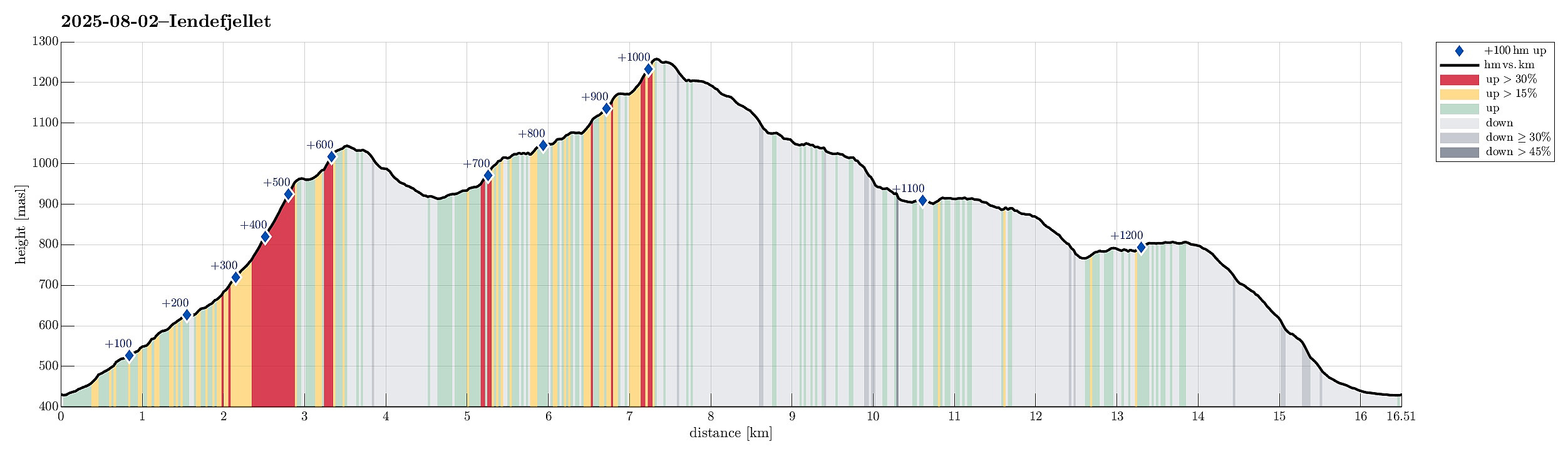 We expected "one last nice day before the rain" and thus aimed at one more nice hike! :-) Without much hesitation, we agreed to make a hike to Iendefjellet, north of Kvamskogen. We took the car from Bergen to Kvamskogen and parked at the southern end of Tryglakleiv, right next to the "main road" across Kvamskogen (road #49). We then started to hike up road Tryglakleiv, aiming at the heights in the southwest of Tryglakleivtjørnane. All of this is easy to find and from "up there" (a bit below 600 masl), the real ascent towards Byrkjefjellet starts (then mostly in northern direction). Following a proper trail, we completed the (partially steep) ascent relatively quickly. It was, however, very hot and we recognized and respected the roughly 600 height meters >>>
Kongsberg north of Ulvik
- Date:
- 04.08.2024
- Characteristic:
- Hike
- Duration:
- 4:00h
- Distance:
- 8.1km
 With relatively low-hanging clouds, we aimed at a simple hike that would remain beneath the clouds, but still offer some nice views, hopefully. After some consideration, we thought that hiking up to Kongsberg near Ulvik could be a good solution. We took the road up from Ulvik to Aurdal and parked right next to the road right after passing over Verafossen. From there, we then followed a forest road that lead initially into Seljestidalen, before then winding up towards Klyvhals on the southeastern side of this valley. South of Røyneskor, this forest road leads then westwards (to Vestrheimskleppe). There, one eventually gets to see over the treetops further below and down to Ulvikafjorden. To continue further upwards to Kongsberg it is then mostly to just follow the forest road further. >>>
From Odda to Buardalen via Ruklenuten
- Date:
- 03.08.2024
- Characteristic:
- Hike
- Duration:
- 8:00h
- Distance:
- 12.1km
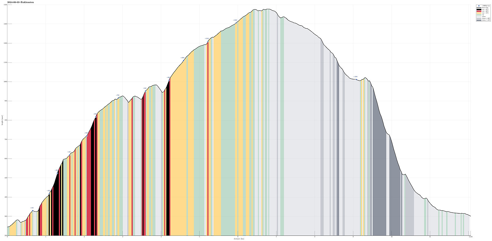 We wished to make a nice hike from Odda and found Eidesnuten as a worthwhile hiking target, promising nice views in multiple directions. Starting from Eidesåsen, some 250masl and about 150 heights meters above Eide in the south of Odda, we followed a very well-marked trail. Even though one may expect more hikers on such a well-treated trail, we did not meet anyone. Within not too long, we arrived at Eidesnuten and found that our expectations regarding the views were indeed well-founded. Not only could we see northwards and out Hardangerfjorden, north of Odda, as well as southwards, across the large lake Sandvinvatnet, but also we got some nice views over to Buarbreen, already from Eidesnuten. From Eidesnuten, our goal had been to ascend further upwards to Ruklenuten (in the northwest >>>
Vikanuten
- Date:
- 02.08.2024
- Characteristic:
- Hike
- Duration:
- 5:30h
- Distance:
- 9.1km
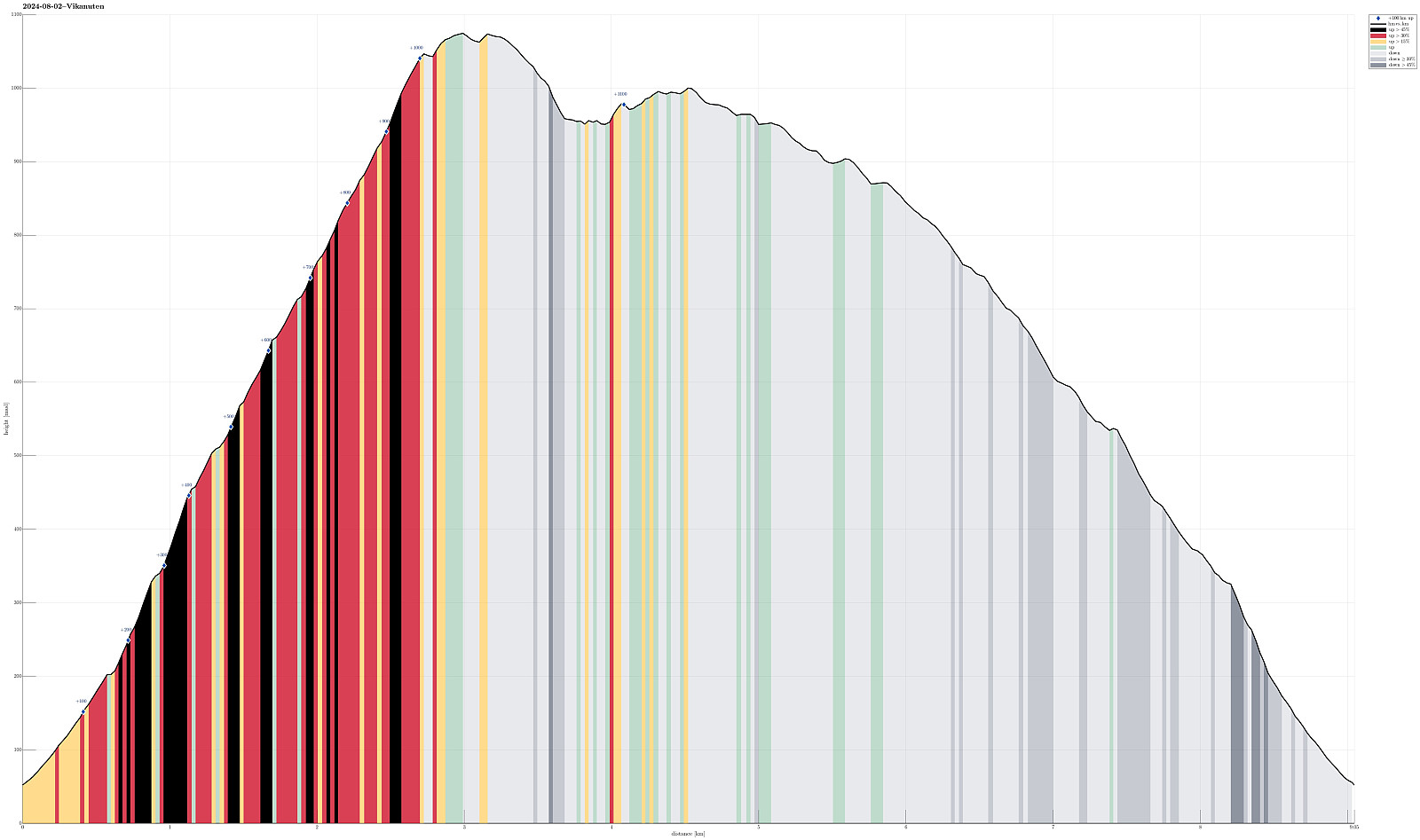 We left work early on this Friday and managed to start hiking around 15h15 right next to road #49 in the southwest of Jondal, where Renndalen comes down from Vikanuten. We followed the very well marked trail upwards, first on the east-side of Renndalen. At about 200masl, we crossed Gjelet to the western side of the valley, continuing our (steep) ascent to Vikanuten then this side. The trail upwards is well-marked and easy to find -- it's definitely steep, but no climbing is necessary (near the top, a few times it is helpful to use a hand in addition for additional stability, though). Especially once above the tree line (maybe around 650masl), one can enjoy marvelous views across Hardangerfjorden from this ascent. Roughly 1050masl, one finds a nice cairn which is marking a particularly >>>
Middagshovden with snowshoes
- Date:
- 01.01.2023
- Characteristic:
- Snowshoe trip
- Duration:
- 3:00h
- Distance:
- 8.9km
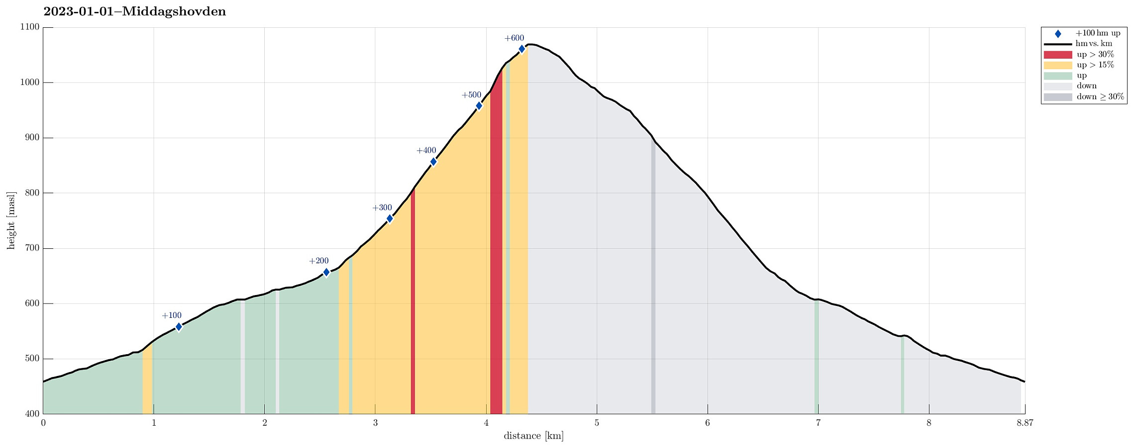 Lovely snowshoe tour on the first day of the year! After first reusing the track from the day before , we then decided to add an extension to Middagshovden. The ascent was a bit demanding (and in the upper part some 50 height meters, or so, were also quite steep), but all-in-all it was very nice and enjoyable. From Middagshovden, we then followed the slightly more traditional route down (in parallel to Ljosegrovi) until we reunited with our tracks from earlier. Really very nice to make such a winter hike with snowshoes! :-)
Selected photos are available as Google photo album .
See also the related FB-page Hiking around Bergen, Norway .
Lovely snowshoe tour on the first day of the year! After first reusing the track from the day before , we then decided to add an extension to Middagshovden. The ascent was a bit demanding (and in the upper part some 50 height meters, or so, were also quite steep), but all-in-all it was very nice and enjoyable. From Middagshovden, we then followed the slightly more traditional route down (in parallel to Ljosegrovi) until we reunited with our tracks from earlier. Really very nice to make such a winter hike with snowshoes! :-)
Selected photos are available as Google photo album .
See also the related FB-page Hiking around Bergen, Norway .
Klyvsnolten and Lauvhovden
- Date:
- 19.10.2021
- Characteristic:
- Hike
- Duration:
- 3:00h
- Distance:
- 7.8km
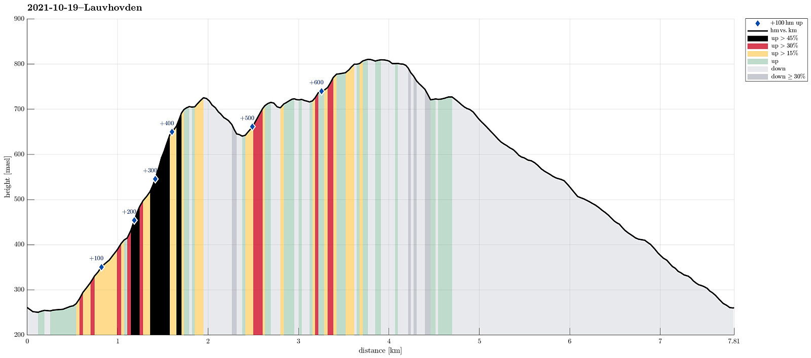 After a two days meeting at Voss, we wished to get some fresh air before darkness would set in. The weather forecast was "challenging" (loads of rain predicted), but shifted at least a little from day to day. We had not given up, but aimed at something non-extreme to account for the circumstances (limited daylight left, non-shiny weather, etc.). My dear hiking friend Harald wished to ascend Lauvhovden (and convinced me then, also). We took the car from Voss along Raundalsvegen to Klyve, where we parked near Svinåni next to a gravel road. To start our hike, we first followed Raundalsvegen a little further, passing between Øvre Klyve and Nedre Klyve, to connect to a forest road that we had seen right next to Rastalii (leading upwards into the direction of Skori and Klyvsnolten). Following >>>
Krampane and Hamlagrøhornet
- Date:
- 04.10.2020
- Characteristic:
- Hike
- Duration:
- 4:00h
- Distance:
- 9.6km
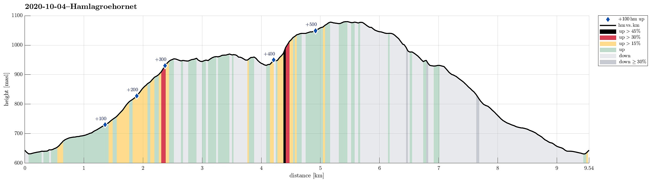 The day after our hike to Kjerringafjellet , we again started from Hamlagrøvegen -- this time, however, into the other, northeastern direction. Our first goal was Krampane, north of the cabin named after Alexander Grieg at Holeberg. We first walked along the western slope of Røvhaugane, before then crossing over to Svartagrovi in northwestern direction. Just a few height meters below 700mosl, we crossed the stream and continued (for a not very long stretch) along the marked trail in northern direction. Roughly where we crossed 700mosl, we diverted from this trail to the left and continued (in northwestern direction) towards the southern ridge of Krampane. Just a bit above 800mosl, then, we had connected to that ridge and continued along it upwards (all the way to Krampane). Up there, we then enjoyed some really >>>
Kjerringafjellet
- Date:
- 03.10.2020
- Characteristic:
- Hike
- Duration:
- 4:30h
- Distance:
- 10.8km
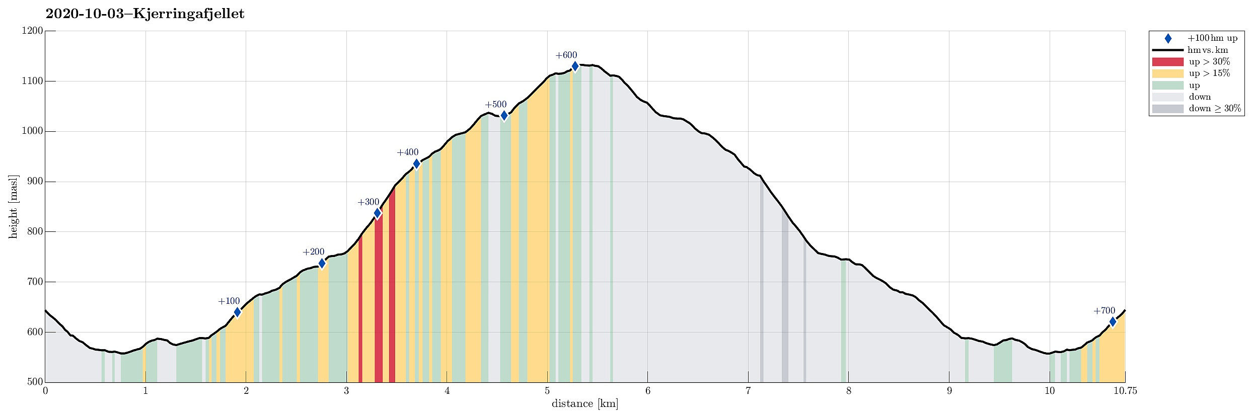 We drove from Bergen to Bergsdalen (via Dale) and parked right where the road through Bergsdalen crosses from Vaksdal district to Voss district. On the southwestern side of the road, we stepped off the parking lot and on to a trail that leads into the direction of Øvretjørni, leading through a field of cabins there. Surrounding Øvretjørni in its northwest, the trail then turns more into a southward direction, aiming for the saddle between Magneknolten and Kjerringafjellet. Once in the west of Magneknolten, the trail surrounds Rjupehaugane in their south until it brings one into a small valley that extens upwards to Hardingskaret in its northwest. Before actually getting there (Hardingskaret), one turns left, again, and towards Kjerringafjellet. A steadily ascending slope leads up to >>>
Hovdane from Brattholo
- Date:
- 08.08.2020
- Characteristic:
- Hillwalk
- Duration:
- 4:00h
- Distance:
- 6.4km
 With a somewhat unclear weather forecast, we aimed at something gentle, not too far up. Driving along E16 (into the direction of Voss), we left the main road a little southwest of Vinje, contiuning for bit into the direction of Hommedalen. Driving up Holbygdvegen to about 250mosl, we found a suitable place near Brattholo to park right next to the road. From there, we started walking along a minor road that winds up towards the eastern flank of Hagahovden. A little over 300mosl then, we left the road (basically where it ends) and continued along a trail that continues further upwards. At about 335mosl, we briefly explored a flag post with some view, before soon returning to the trail and following further upwards. At about 500mosl we then arrived at a nice shelter at Hovdane, enjoying >>>
Tverrfjellet from Bidne
- Date:
- 06.08.2020
- Characteristic:
- Hike
- Duration:
- 5:00h
- Distance:
- 13.6km
 The weather forecast was moderately OK (quite a bit overcast with realistic chances for some rain), so we aimed for a moderate hike, bringing us not too high up (and into the clouds). Since we had not been there before and expected at least some nice views from up there, our choice was to hike up to Tverrfjellet from Oppheim. We thus drove to Oppheim first and then left the main road (E16) near Framnes to drive up a simple road into the direction of Bidne. A few meters after reaching Bidne (that's about one kilometer from E16), we turned right (eastwards) and drove a few meters more towards Bidneshovden. There, we parked and started our hike (in northern direction, on a forest road). We followed the forest road northwards, staying on the western side of Sundsvålselvi, steadily ascending >>>
