Arkiv - dato
Arkiv - aktivitet
-
Annen tur (1)
- Kajakkpadling (1)
-
Annen vintertur (4)
- Trugetur (4)
- Fottur (740)
-
Skitur (4)
- Fjellskitur (4)
-
Sykkeltur (137)
- Blandet sykling (51)
- Gatesykling (9)
Arkiv - Etter geografi
"Peakbookvenner"


Lister jeg samler etter
-
Bergen ≥ 50m pf. og ≥ 100 m.o.h.
(87/89)
 97%
97% -
Most dominating tops of the Bergen peninsula
(68/75)
90%
-
Utvalgte topper og turmål i Bergen
(316/350)
90%
-
Alle topper i Bergen
(357/398)
89%
-
Opptur Bergen
(100/113)
88%
-
De syv fjell rundt Bergen
(6/7)
85%
-
Sund ≥ 50m pf.
(14/18)
77%
-
Os ≥ 50m pf.
(25/34)
73%
-
Søyler (fastmerker) i Bergen
(68/100)
68%
-
Fjell ≥ 50m pf.
(21/32)
65%

Random Walk in Fyllingsdalen
- Dato:
- 18.12.2022
- Turtype:
- Spasertur
- Turlengde:
- 2:00t
- Distanse:
- 8,4km
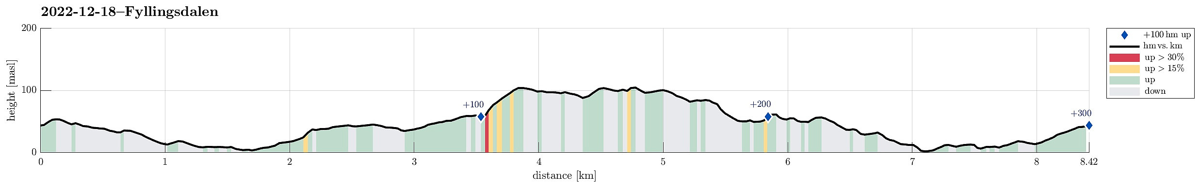 Just a "random walk" in Fyllingsdalen -- no more to write! :-)
See also the related FB-page Hiking around Bergen, Norway .
Just a "random walk" in Fyllingsdalen -- no more to write! :-)
See also the related FB-page Hiking around Bergen, Norway .
Snowy Kanadaskogen
- Dato:
- 17.12.2022
- Turtype:
- Spasertur
- Turlengde:
- 1:30t
- Distanse:
- 5,8km
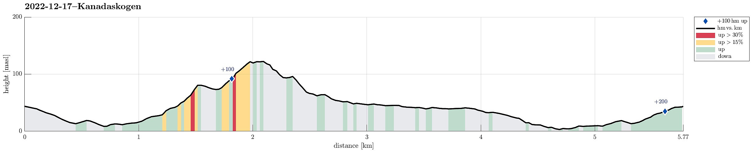 Just a nice walk into snowy Kanadaskogen, visiting Langaheia in the east of Store Krokatjørna.
Selected photos are available as Google photo album .
See also the related FB-page Hiking around Bergen, Norway .
Just a nice walk into snowy Kanadaskogen, visiting Langaheia in the east of Store Krokatjørna.
Selected photos are available as Google photo album .
See also the related FB-page Hiking around Bergen, Norway .
Exploring Høvik
- Dato:
- 20.07.2022
- Turtype:
- Spasertur
- Turlengde:
- 1:00t
- Distanse:
- 3,0km
 To get a bit of fresh air in the evening, we decided to explore Høvik in Eksingedalen. After first walking along the few roads in Høvik, we started a short ascent to Svedgjeli in northeasern direction (below Åsen), following a stretch of old Reitlevegen through Eksingedalen. From there, we then had some nice overview of Høvik. When walking back, we also explored the wide bend of the Ekso river (in the south of Høvik) that probably is responsible for the suffix of name Høvik.
Selected photos are available as Google photo album .
See also the related FB-page Hiking around Bergen, Norway .
On the Web Archive , one can still find information about Reitlevegen .
To get a bit of fresh air in the evening, we decided to explore Høvik in Eksingedalen. After first walking along the few roads in Høvik, we started a short ascent to Svedgjeli in northeasern direction (below Åsen), following a stretch of old Reitlevegen through Eksingedalen. From there, we then had some nice overview of Høvik. When walking back, we also explored the wide bend of the Ekso river (in the south of Høvik) that probably is responsible for the suffix of name Høvik.
Selected photos are available as Google photo album .
See also the related FB-page Hiking around Bergen, Norway .
On the Web Archive , one can still find information about Reitlevegen .
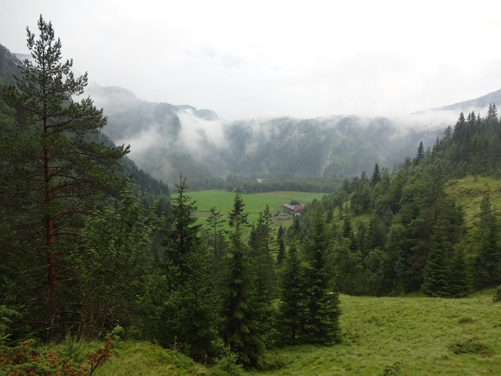
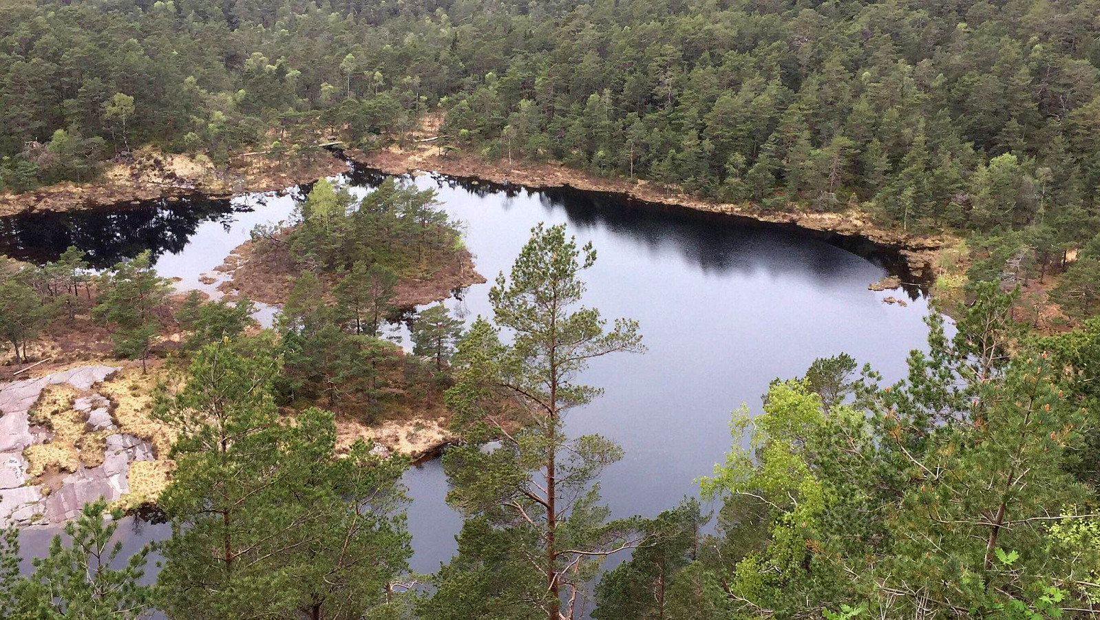
Kanadaskogen with Storhovden
- Dato:
- 02.07.2022
- Turtype:
- Spasertur
- Turlengde:
- 2:30t
- Distanse:
- 8,0km
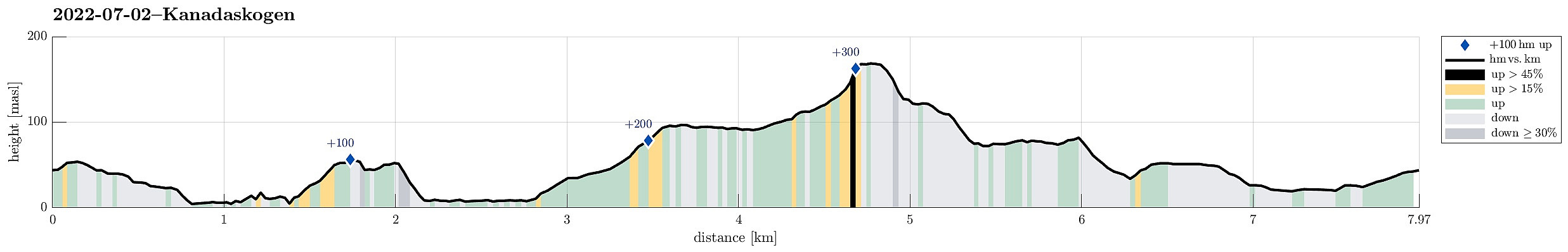 One of many rounds through Kanadaskogen, starting along Gjeddevatnet, also including Fureneset, this time, and then continuing to Bjørndalsvatnet and further to Svartatjørna. On our way back, we included Storhovden and Syningen, then passing by Stora Krokatjørna.
Selected photos are available as Google photo album .
See also the related FB-page Hiking around Bergen, Norway .
One of many rounds through Kanadaskogen, starting along Gjeddevatnet, also including Fureneset, this time, and then continuing to Bjørndalsvatnet and further to Svartatjørna. On our way back, we included Storhovden and Syningen, then passing by Stora Krokatjørna.
Selected photos are available as Google photo album .
See also the related FB-page Hiking around Bergen, Norway .
Knappen from Varden
- Dato:
- 21.05.2022
- Turtype:
- Spasertur
- Turlengde:
- 1:30t
- Distanse:
- 4,6km
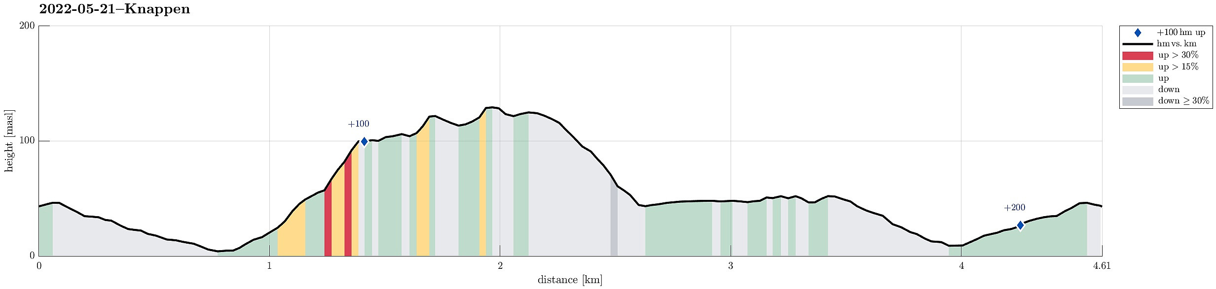 Just a standard walk over Knappen from Varden.
See also the related FB-page Hiking around Bergen, Norway .
Petter Bjørstad has a useful page about Knappen .
Web page UT.no from the Norwegian Trekking Association recommends another hike to Knappen .
Just a standard walk over Knappen from Varden.
See also the related FB-page Hiking around Bergen, Norway .
Petter Bjørstad has a useful page about Knappen .
Web page UT.no from the Norwegian Trekking Association recommends another hike to Knappen .
Oasen from Varden and back through Kanadaskogen
- Dato:
- 14.05.2022
- Turtype:
- Spasertur
- Turlengde:
- 3:00t
- Distanse:
- 10,2km
 After first walking to Oasen from Varden, I took a detour back to Varden through Kanadaskogen, including a crossing of Skjenhaugane, Langaheia, and Hesjaholten.
See also the related FB-page Hiking around Bergen, Norway .
After first walking to Oasen from Varden, I took a detour back to Varden through Kanadaskogen, including a crossing of Skjenhaugane, Langaheia, and Hesjaholten.
See also the related FB-page Hiking around Bergen, Norway .
Purkeneset from Eide
- Dato:
- 02.04.2022
- Turtype:
- Spasertur
- Turlengde:
- 2:30t
- Distanse:
- 7,6km
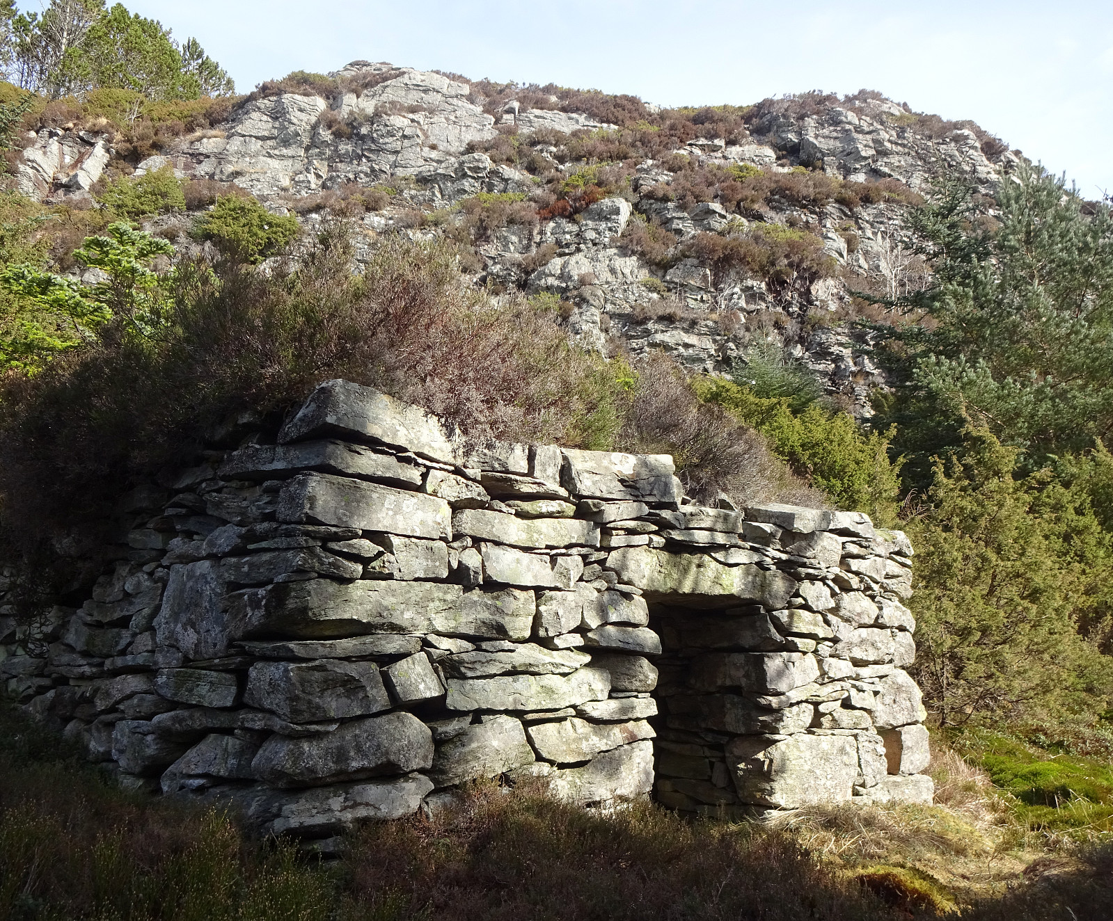 On a day with mixed weather, we made a short hike to Purkeneset north of Eide on Sotra. We parked near the road and crossed first Varden and Kyrkjehaugen before connecting to the trail that leads out to Purkeneset. From the top of Purkeneset we enjoyed some nice view across Kørelen, i.e., the rather big lake in the west of Hammarsland. After walking back along the same trail, we included a short excursion to Hopen in the north of Spilda. From there, we just walked back to Eide and called it a day.
Selected photos are available as Google photo album .
See also the related FB-page Hiking around Bergen, Norway .
Web page UT.no from the Norwegian Trekking Association recommends another hike to Purkaneset .
On a day with mixed weather, we made a short hike to Purkeneset north of Eide on Sotra. We parked near the road and crossed first Varden and Kyrkjehaugen before connecting to the trail that leads out to Purkeneset. From the top of Purkeneset we enjoyed some nice view across Kørelen, i.e., the rather big lake in the west of Hammarsland. After walking back along the same trail, we included a short excursion to Hopen in the north of Spilda. From there, we just walked back to Eide and called it a day.
Selected photos are available as Google photo album .
See also the related FB-page Hiking around Bergen, Norway .
Web page UT.no from the Norwegian Trekking Association recommends another hike to Purkaneset .
Round around Bondegården
- Dato:
- 24.12.2021
- Turtype:
- Spasertur
- Turlengde:
- 1:30t
- Distanse:
- 3,6km
 Just a nice xMas round around Bondegården in Fyllingsdalen.
Selected photos are available as Google photo album .
See also the related FB-page Hiking around Bergen, Norway .
Just a nice xMas round around Bondegården in Fyllingsdalen.
Selected photos are available as Google photo album .
See also the related FB-page Hiking around Bergen, Norway .
Vardetangen
- Dato:
- 14.03.2021
- Turtype:
- Spasertur
- Turlengde:
- 1:30t
- Distanse:
- 5,8km
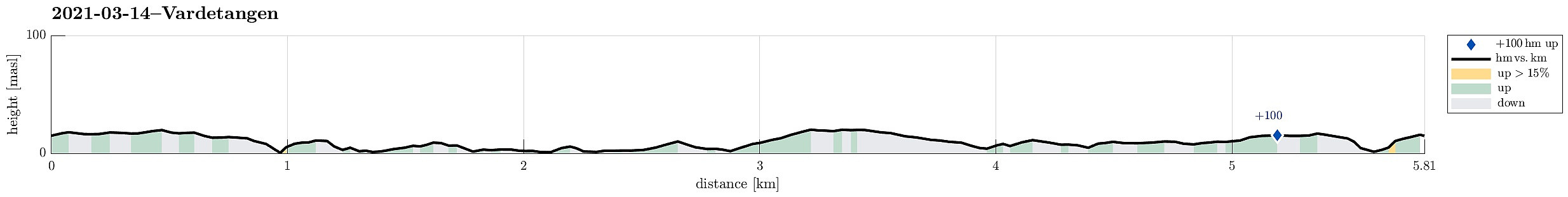 The plan for this all-in-all comparably wet day was to visit Vardetangen, i.e., Norway's western-most point, when disregarding islands. Driving north from Bergen we passed through Knarvik and continued further northwards Lindås and Mongstad. Soon after, we arrived in Austrheim and parked near Torvneset right next to Ervika. From there, it was then a short walk towards Vardetangen, where we recognized that quite a bit had changed since our last visit (the cabin, for ex., is new and also the trail there has been upgraded). After staying at Vardetangen for a short while, we continued towards Årvika along the northern shoreline. There, we used a nice wooden shelter to have a short break with some nice snacks. At last, we completed a little round back to the parking place, coming by Træsvika >>>
Short double-round in Milde
- Dato:
- 17.10.2020
- Turtype:
- Spasertur
- Turlengde:
- 1:30t
- Distanse:
- 4,7km
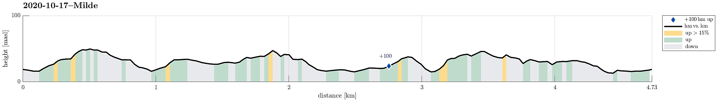 The weather forecast was not too good and also there were other things to do, so the decision was to do something near and quick. We drove south through Ytrebygda, crossing Flyplassvegen to continue further south, towards Milde, following road #573. Coming closer, one follows the signs to Arboretet i Milde. We parked near a Kindergarden along Mildevegen and started our walk in northeastern direction. Once in the green, we turned right and towards Nepegjerdhaugen, which is the highest "top" on the island. Then, we turned back into the forest and headed towards Arboretet. We then walked southwards along a nice trail on the western side of Arboretet. At Naustdalen, we turned right (and towards the school there). With a bit of left and right, we then ended up on Lysthushaugen >>>
