Arkiv - dato
Arkiv - aktivitet
-
Annen tur (1)
- Kajakkpadling (1)
-
Annen vintertur (4)
- Trugetur (4)
- Fottur (740)
-
Skitur (4)
- Fjellskitur (4)
-
Sykkeltur (137)
- Blandet sykling (51)
- Gatesykling (9)
Arkiv - Etter geografi
"Peakbookvenner"


Lister jeg samler etter
-
Bergen ≥ 50m pf. og ≥ 100 m.o.h.
(87/89)
 97%
97% -
Most dominating tops of the Bergen peninsula
(68/75)
90%
-
Utvalgte topper og turmål i Bergen
(316/350)
90%
-
Alle topper i Bergen
(357/398)
89%
-
Opptur Bergen
(100/113)
88%
-
De syv fjell rundt Bergen
(6/7)
85%
-
Sund ≥ 50m pf.
(14/18)
77%
-
Os ≥ 50m pf.
(25/34)
73%
-
Søyler (fastmerker) i Bergen
(68/100)
68%
-
Fjell ≥ 50m pf.
(21/32)
65%

Allestadhaugen
- Dato:
- 30.03.2026
- Turtype:
- Fjelltur
- Turlengde:
- 1:00t
- Distanse:
- 4,4km
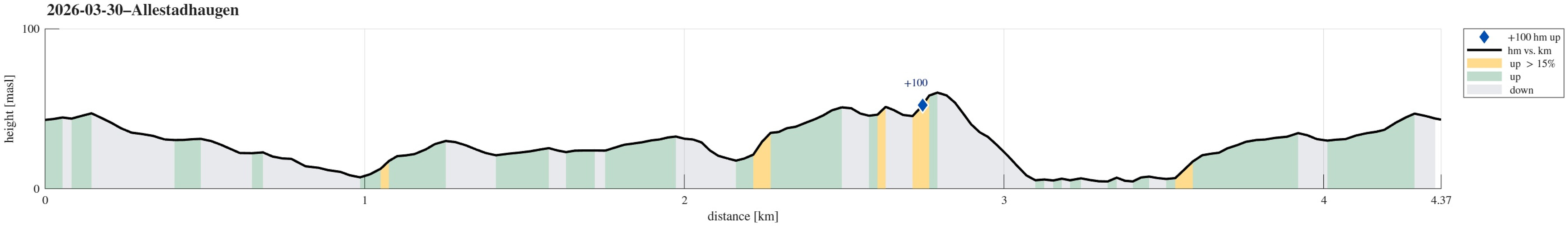 Even though the weather was not perfect, we still wished to get some fresh air. After first walking around Varden, we then followed the new (and partially finished) walking trail in the northwest of the soccer fields. From there, it was then just a short round up and down Allestadhaugen, before we headed back along Gjeddevatnet.
See also the related FB-page Hiking around Bergen, Norway .
Even though the weather was not perfect, we still wished to get some fresh air. After first walking around Varden, we then followed the new (and partially finished) walking trail in the northwest of the soccer fields. From there, it was then just a short round up and down Allestadhaugen, before we headed back along Gjeddevatnet.
See also the related FB-page Hiking around Bergen, Norway .
Marmorøyen, Flatøyna, and Ulvøyna
- Dato:
- 08.02.2026
- Turtype:
- Fjelltur
- Turlengde:
- 1:30t
- Distanse:
- 5,0km
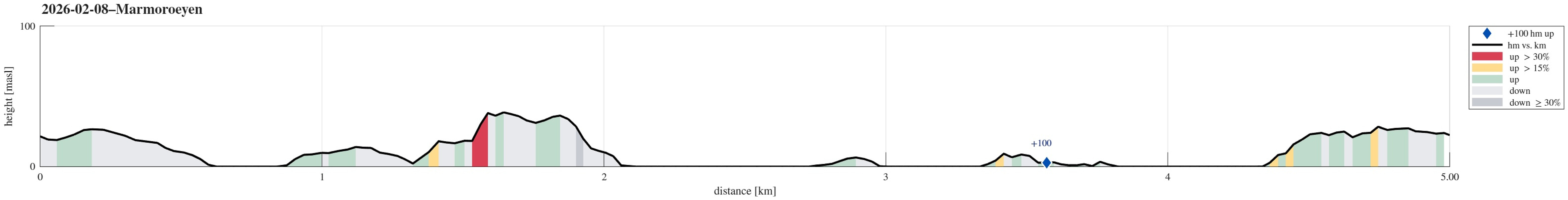 With everthing still frozen, we thought that it could work to simply walk over to Marmorøyen in Nordåsvatnet. We parked near Troldhaugen and approached the ice via Frants Beyers veg. While the ice on top of Nordåsvatnet indeed was thick and sturdy, it wasn't all trivial to get onto it -- due to the tides, the ice was broken up near the shore. One attempt to get onto the ice right at the beginning then ended up with breaking into the water right away (just with one leg). After finding a better spot, it then worked without problems. This little mishap in the beginning, however, resulted in the decimation of the walking team (from three down to two). Once on the ice, the next question was where a good "landing place" would be on Marmorøyen. Heading a bit outwards of Marmorsundet >>>
Ørnahaugen, then back across Gjeddevatnet
- Dato:
- 01.02.2026
- Turtype:
- Fjelltur
- Turlengde:
- 2:00t
- Distanse:
- 5,9km
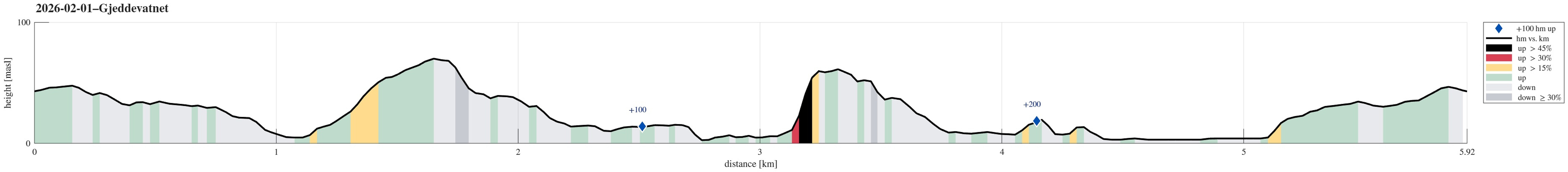 Yet again we just wished to go for a short walk. We started into the direction of Knappen, but decided to aim northwards, instead, this time. Just walking along the streets around Bjørgedalen, we made it to Kjerreidvika. We then thought that we could use the wintery conditions to ascend to Ørnahaugen via its steep southeastern side. This worked out well. We then descended back down from Ørnahaugen towards the east (Sæleidet). We then thought that we could use the icy lake cover of Bjørndalsvatnet to get over to Elvareidet without disturbing the people living there. On the other side, we first tried to get up this rather narrow valley north of Elvareidet. Since we encountered too much ice there, however, we abandoned this plan. Instead, we then thought that it would be something >>>
Local exploration in Kanadaskogen
- Dato:
- 31.01.2026
- Turtype:
- Fjelltur
- Turlengde:
- 1:30t
- Distanse:
- 4,3km
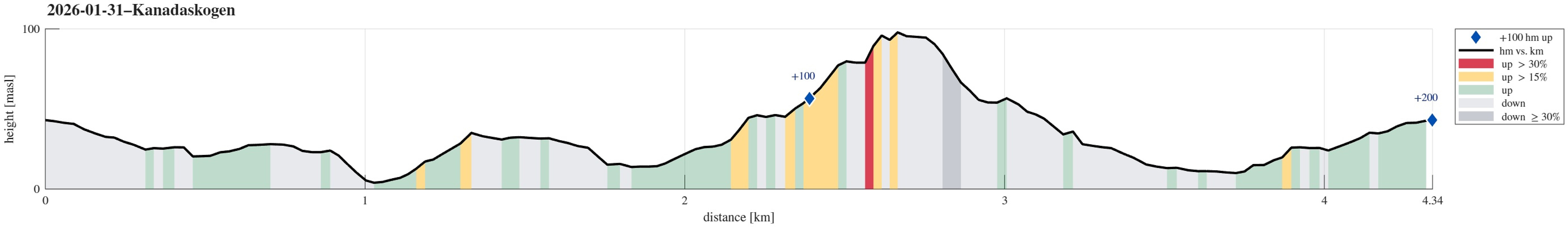 We wished to get some fresh air around our heads. After first heading towards the soccer fields north of Varden, we then decided to visit Gjeddevatnet, also. On the way down to Skogadotten, we came across a part of the forest with lots of ice -- interesting! :-) We then headed towards Skaget, just a few meters further north, where also the terrain -- otherwise very wet -- was deeply frozen. This gave us the opportunity to have a quick look at some new construction there (it seems as if the area is prepared for visitors there). After then walking back up to the sports arena, we still wished to do a bit more. Walking further north, we ended up exploring the hills between Hesjakollen and Krokatjønnveien. Once satisfied there, we then headed back to Varden.
Selected photos are available >>>
We wished to get some fresh air around our heads. After first heading towards the soccer fields north of Varden, we then decided to visit Gjeddevatnet, also. On the way down to Skogadotten, we came across a part of the forest with lots of ice -- interesting! :-) We then headed towards Skaget, just a few meters further north, where also the terrain -- otherwise very wet -- was deeply frozen. This gave us the opportunity to have a quick look at some new construction there (it seems as if the area is prepared for visitors there). After then walking back up to the sports arena, we still wished to do a bit more. Walking further north, we ended up exploring the hills between Hesjakollen and Krokatjønnveien. Once satisfied there, we then headed back to Varden.
Selected photos are available >>>
Via Melkeplassen to Bergen
- Dato:
- 22.01.2026
- Turtype:
- Fjelltur
- Turlengde:
- 2:30t
- Distanse:
- 9,1km
 We headed for a meeting in central Bergen and since we had some extra time on our hands (or maybe better: on our feet?), we decided to just walk. Crossing over Melkeplassen, we just made it nicely in time for our meeting.
See also the related FB-page Hiking around Bergen, Norway .
We headed for a meeting in central Bergen and since we had some extra time on our hands (or maybe better: on our feet?), we decided to just walk. Crossing over Melkeplassen, we just made it nicely in time for our meeting.
See also the related FB-page Hiking around Bergen, Norway .
Visiting the Fantoft stave church on a foggy day
- Dato:
- 18.01.2026
- Turtype:
- Fjelltur
- Turlengde:
- 0:30t
- Distanse:
- 0,5km
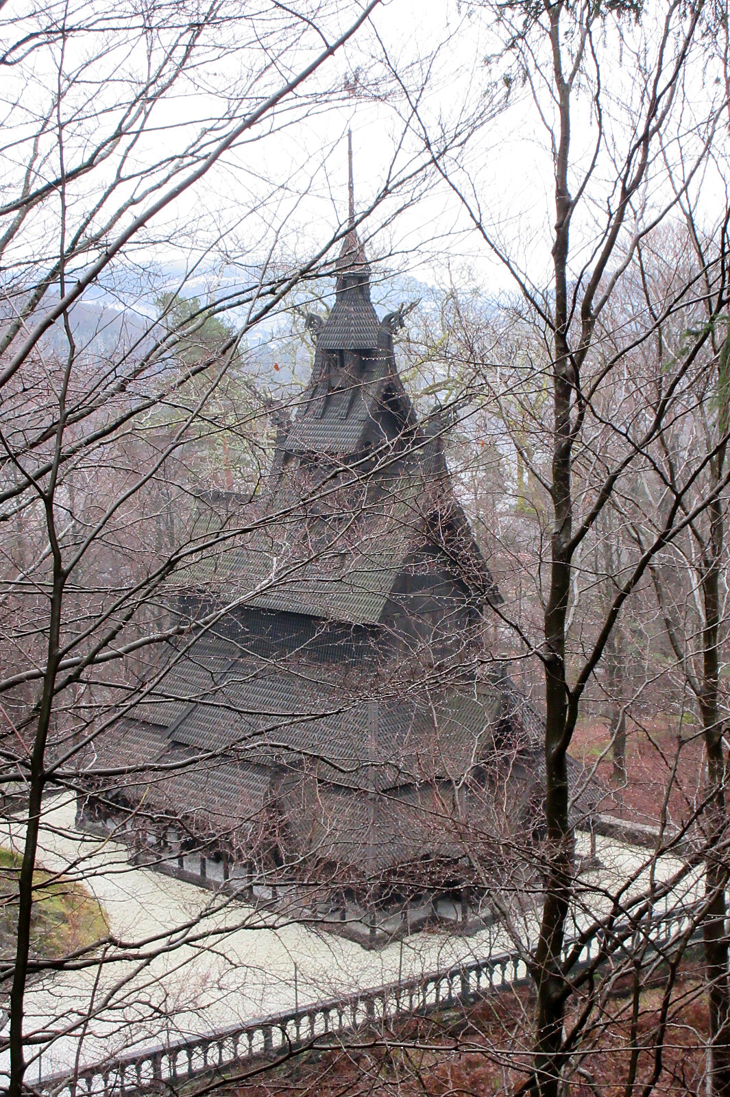 Given the particular foggy day, which did not really invite to any extended outing, we decided to quickly visit the stave church at Fantoft.
See also the related FB-page Hiking around Bergen, Norway .
Given the particular foggy day, which did not really invite to any extended outing, we decided to quickly visit the stave church at Fantoft.
See also the related FB-page Hiking around Bergen, Norway .
Skogsøyna on a nice winter day
- Dato:
- 17.01.2026
- Turtype:
- Fjelltur
- Turlengde:
- 2:00t
- Distanse:
- 5,3km
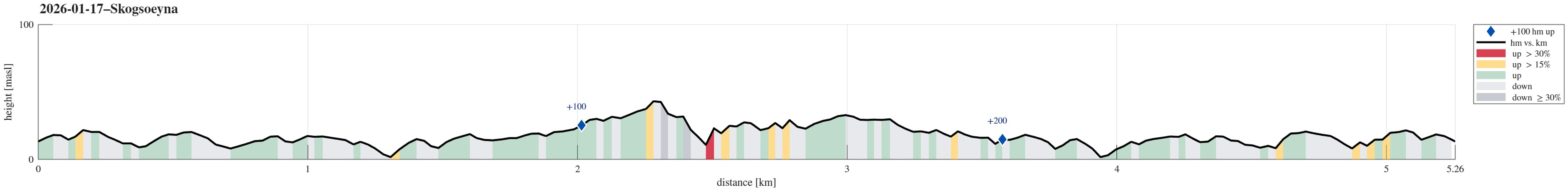 With a friend, visiting from abroad, we chose Skogsøyna as a very nice outing option. Following the main trail, which by now has been upgraded in multiple places, we soon reached Skogsøytua at the southwestern end of the island. After walking around the spectacular cliff area out there, we then walked basically the same (main) trail back. As always very nice to visit Skogsøyna!
Selected photos are available as Google photo album .
See also the related FB-page Hiking around Bergen, Norway .
With a friend, visiting from abroad, we chose Skogsøyna as a very nice outing option. Following the main trail, which by now has been upgraded in multiple places, we soon reached Skogsøytua at the southwestern end of the island. After walking around the spectacular cliff area out there, we then walked basically the same (main) trail back. As always very nice to visit Skogsøyna!
Selected photos are available as Google photo album .
See also the related FB-page Hiking around Bergen, Norway .
Round around Stora Krokatjørna
- Dato:
- 11.01.2026
- Turtype:
- Fjelltur
- Turlengde:
- 1:30t
- Distanse:
- 6,6km
 We first thought that this "only" would be a very short excursion in the neighborhood (and so we stepped onto the small peninsula in the west of Sælevatnet for a short round), but then we still decided to make a slightly longer round nonetheless, leaving Varden in northwards direction in order to get into Kanadaskogen. At Stora Krokatjørna, we decided to use the icy condition to walk around the lake (instead of crossing over Langaheia as usually). We then turned around, heading towards Hesjaholten. At last, instead of just walking back along some roads, we decided to pass by frozen Gjeddevatnet to get back to Varden. There, we also used the frozen condition to pass by Myratjørna, which usually is not recommended (too wet).
Selected photos are available as Google photo album .
See also the related >>>
We first thought that this "only" would be a very short excursion in the neighborhood (and so we stepped onto the small peninsula in the west of Sælevatnet for a short round), but then we still decided to make a slightly longer round nonetheless, leaving Varden in northwards direction in order to get into Kanadaskogen. At Stora Krokatjørna, we decided to use the icy condition to walk around the lake (instead of crossing over Langaheia as usually). We then turned around, heading towards Hesjaholten. At last, instead of just walking back along some roads, we decided to pass by frozen Gjeddevatnet to get back to Varden. There, we also used the frozen condition to pass by Myratjørna, which usually is not recommended (too wet).
Selected photos are available as Google photo album .
See also the related >>>
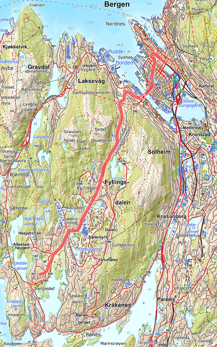
Fyllingsdalen round with Gullsteinen
- Dato:
- 04.01.2026
- Turtype:
- Fjelltur
- Turlengde:
- 4:00t
- Distanse:
- 13,9km
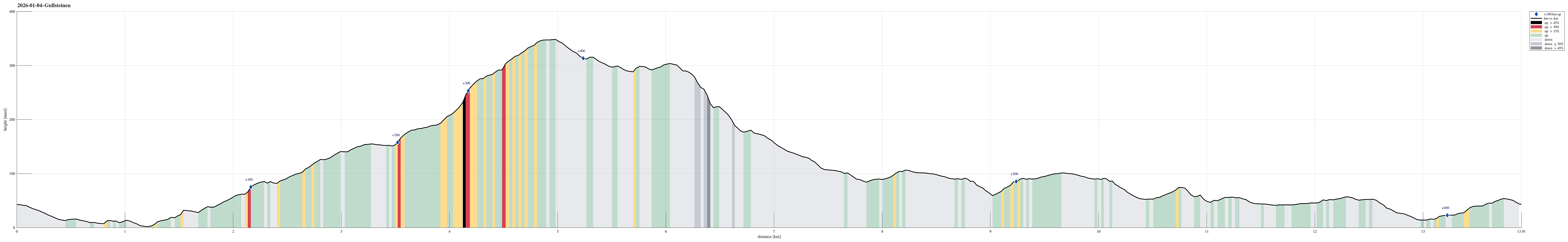 We were up for a Fyllingsdalen round and even though it was already a bit late we still thought that including Gullsteinen was doable (and so it was). From Varden, we first surrounded Bondegården at Sælehaugen before then aiming at Rekdalsveien. After connecting to Hattedalen, we then walked up to Bråtet in order to get started with our ascent to Gullsteinen. Even though it was icy in a few places, we still enjoyed the walk over the ridge very much. After passing over Gullsteinen, we then took a trail to Rosenlund, which only was a little bit of a challenge in the slight steeper sections due to the snow and ice. The way back towards the south of Fyllingsdalen was then on roads, mostly, given that it had turned into a dark night by then.
Selected photos are available as Google photo album .
See also the >>>
We were up for a Fyllingsdalen round and even though it was already a bit late we still thought that including Gullsteinen was doable (and so it was). From Varden, we first surrounded Bondegården at Sælehaugen before then aiming at Rekdalsveien. After connecting to Hattedalen, we then walked up to Bråtet in order to get started with our ascent to Gullsteinen. Even though it was icy in a few places, we still enjoyed the walk over the ridge very much. After passing over Gullsteinen, we then took a trail to Rosenlund, which only was a little bit of a challenge in the slight steeper sections due to the snow and ice. The way back towards the south of Fyllingsdalen was then on roads, mostly, given that it had turned into a dark night by then.
Selected photos are available as Google photo album .
See also the >>>
Storhovden and Svartaberget from Varden
- Dato:
- 02.01.2026
- Turtype:
- Fjelltur
- Turlengde:
- 3:00t
- Distanse:
- 9,5km
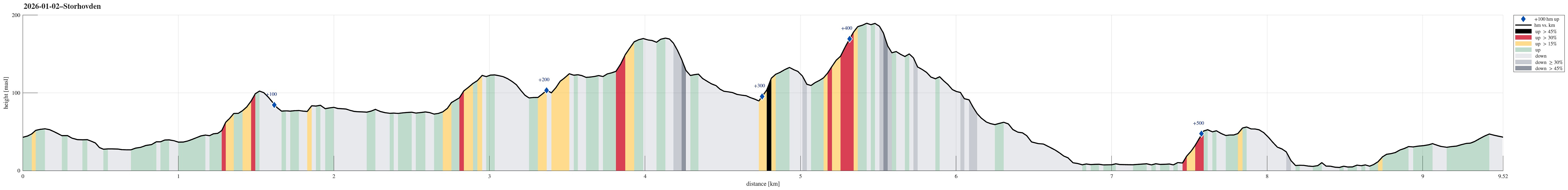 We started northwards from Varden, crossing the soccer fields to get closer to Kanadaskogen near Hesjaholten. After paying Hesjaholten a short visit, we continued further towards Krokatjørna. This time, we decided to cross over Langaheia from the south, before connecting to Storhovden via Spelhaugen. Since the day was indeed very nice, we then decided to also include Svartaberget via Storamyra where it was nice to also look up to TOBRIK. On Svartaberget, we then enjoyed a really nice winter view towards the west before starting our walk back southwards. After passing by Bjørndalsvatnet and Gjeddevatnet, we arrived back at Varden with good satisfaction about the very nice day!
Selected photos are available as Google photo album .
See also the related FB-page Hiking around Bergen, Norway .
We started northwards from Varden, crossing the soccer fields to get closer to Kanadaskogen near Hesjaholten. After paying Hesjaholten a short visit, we continued further towards Krokatjørna. This time, we decided to cross over Langaheia from the south, before connecting to Storhovden via Spelhaugen. Since the day was indeed very nice, we then decided to also include Svartaberget via Storamyra where it was nice to also look up to TOBRIK. On Svartaberget, we then enjoyed a really nice winter view towards the west before starting our walk back southwards. After passing by Bjørndalsvatnet and Gjeddevatnet, we arrived back at Varden with good satisfaction about the very nice day!
Selected photos are available as Google photo album .
See also the related FB-page Hiking around Bergen, Norway .
