Archive - Date
Archive - Activity
-
Bike trip (137)
- Bike trip - mixed (51)
- Bike trip - road (9)
-
Other trip (1)
- Kayaking (1)
-
Other winter trip (4)
- Snowshoe trip (4)
- Ski trip (4)
- Trip by foot (740)
Archive - Geography
Peakbook-Friends


Collected lists
-
Bergen ≥ 50m pf. og ≥ 100 m.o.h.
(87/89)
 97%
97% -
Most dominating tops of the Bergen peninsula
(68/75)
90%
-
Utvalgte topper og turmål i Bergen
(316/350)
90%
-
Alle topper i Bergen
(357/398)
89%
-
Opptur Bergen
(100/113)
88%
-
De syv fjell rundt Bergen
(6/7)
85%
-
Sund ≥ 50m pf.
(14/18)
77%
-
Os ≥ 50m pf.
(25/34)
73%
-
Søyler (fastmerker) i Bergen
(68/100)
68%
-
Fjell ≥ 50m pf.
(21/32)
65%

Nonkletten and Storavika on Korsneset
- Date:
- 30.05.2020
- Characteristic:
- Hillwalk
- Duration:
- 2:30h
- Distance:
- 7.8km
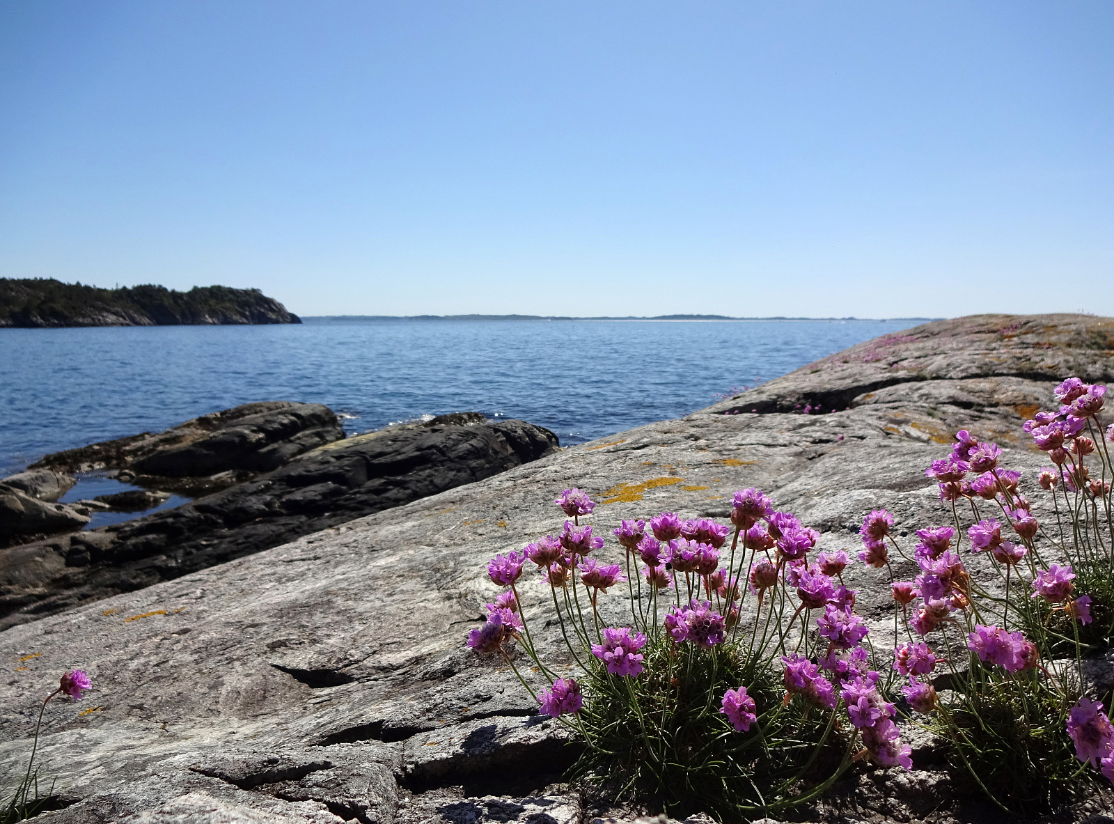 With limited time available, and a nice, warm, and sunny day, we decided to make a medium-long hike on Korsneset with nice Storavika as our main trip goal. Driving by Krokeide and continuing further onto Korsneset, we continued all the way to the junction east of Tverrhaugen, where parking is conveniently possible. Before heading towards Storvika, we wished to include Nonkletten, northeast of the parking place. We thus walked for a few meters back the road that we had come. Maybe some 200m into this, we turned left onto a proper trail, leaving in northwards direction. This trail leads nicely upwards to a nice minor hill in the west of Nonkletten. There, on a minor saddle at about 95mosl, we decided to leave the trail and head eastwards into the direction of Nonkletten. Even though one >>>
Evening Løvstakken
- Date:
- 26.05.2020
- Characteristic:
- Hillwalk
- Duration:
- 1:30h
- Distance:
- 4.6km
 Spontaneously, we decided to do a quick after-work sprint up Løvstakken (the steep way). We parked near the SPAR shop "Sikthaugen" (above Sikthaugen Terrasse) and walked up the pedestrians' connection to Kirsten Flagstads vei. From there, we continued along Rosenlundveien (up to house 43), before taking the trail that ascends steeply underneath the power line in Eastern direction. At about 350mosl, the steepest part of the trail starts (roughly in Northern direction). A bit more the 50 meters higher, one comes out and can enjoy some nice views over Fyllingsdalen. From there, it's then "just" following the trail all to the top of Fyllingsdalen. Definitely a nice alternative of an ascent to Løvstakken! From the top, we then followed the Northern ridge down (into the >>>
Gravdalsfjellet from Betanien
- Date:
- 18.05.2020
- Characteristic:
- Hillwalk
- Duration:
- 1:00h
- Distance:
- 3.7km
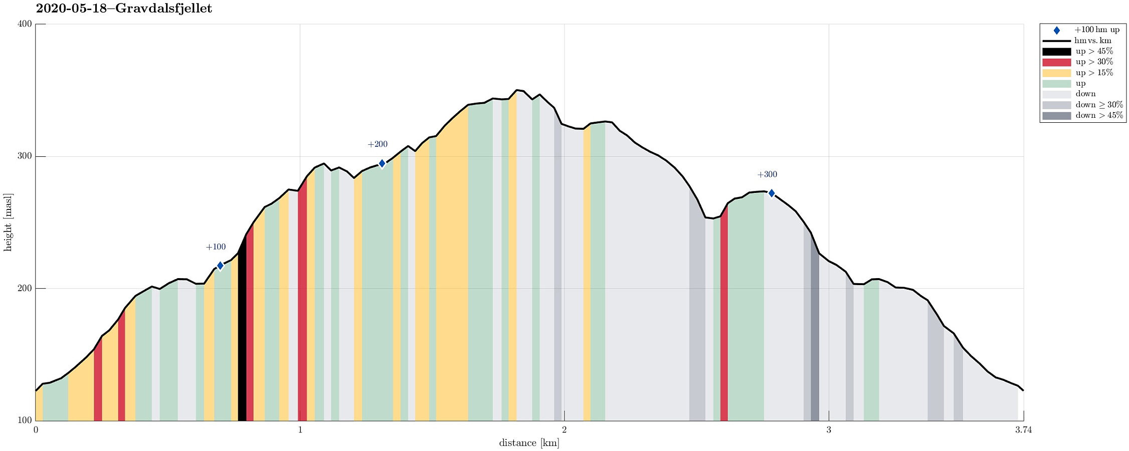 To get some fresh air, we decided to make a short hike up Gravdalsfjellet. We started at Betanien near Vestlund in Fyllingsdalen, Bergen, and head first northwards before then turning left (westwards) into the direction of Gravdalsfjellet. Right after passing by Brattheim, we took the stairs up into the direction of Viggohytten. As soon as we came out on top, however, we made a short detour to visit Kjerringen på Nipen, from where one can enjoy excellent views over Fyllingsdalen. We then headed back to the trail and up to Viggohytten before we continued further upwards to visit near Gravdalsfjellet. From there, we took another trail down (in the west of Gravdalsfjellet. After this short detour, we connected back with the trail that we had taken up near Brattheim. From there, it was >>>
Hamrefjellet
- Date:
- 09.05.2020
- Characteristic:
- Hillwalk
- Duration:
- 2:00h
- Distance:
- 7.6km
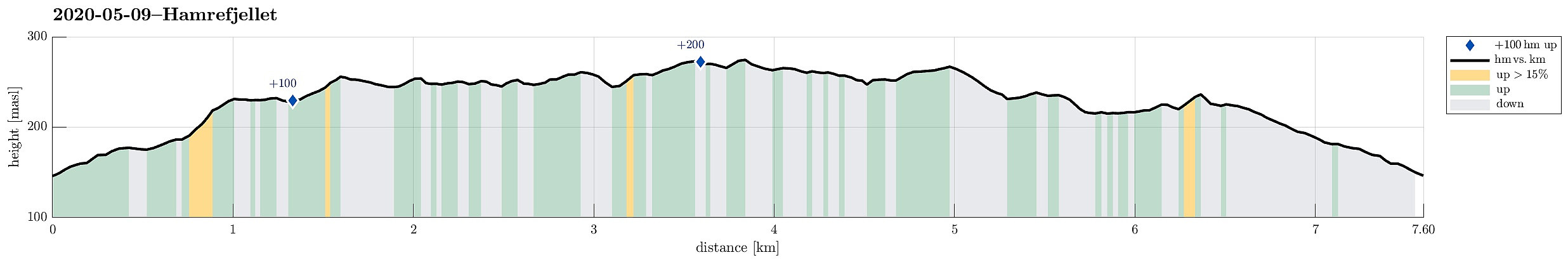 Between two visits of shops, we wished to get some fresh air. Since we were close already, we decided to go a quick round around Hamrefjellet. Since we wished to start with Tornetfjellet, we drove into the direction of Smørås (just to find out that parking is non-trivial there -- clearly, those who live there do not like hikers to park up there). We thus parked quite a bit longer down along Smøråsvegen and walked back up from there. We then ascended Torneberget from Smøråsvegen (only a few meters up), before continuing along a nice trail that stretches over the heights into southern direction (towards Hamrefjellet). Passing by Myrasmettet, we ascended Vardane (also only a few meters up). We next thought to take a look at Vallastølen. Instead of walking "down" to Militærvegen, >>>
Wild Golta
- Date:
- 13.04.2020
- Characteristic:
- Hillwalk
- Duration:
- 3:00h
- Distance:
- 5.1km
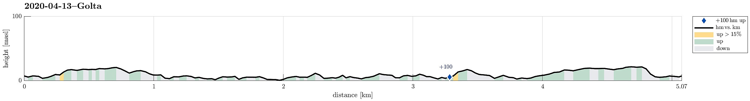 The weather forecast was "interesting": 3 or 4 degrees Celsius and strong winds from the north (with gale warnings nearby). Sounds like a nice day for another trip to the outer islands! :-) This time, we chose Golta (south of Telavåg and west of Glesvær), which is wild and nice! We parked at the parking lot near the inner end of Vogga and started our short hike from there. The route is trivial to find and also not very long. Within a few minutes one gets out to the wild rocks near the North Atlantic. And clearly we weren't disappointed (again): very impressive, when the wind works the sea so hard! We walked for a longer while around the rocks and enjoyed the atmosphere, rounding Lutavika and then also Midtvika, before heading back. Even though a shorter trip, it's definitely >>>
Short round over Gullsteinen
- Date:
- 04.04.2020
- Characteristic:
- Hillwalk
- Duration:
- 1:30h
- Distance:
- 3.9km
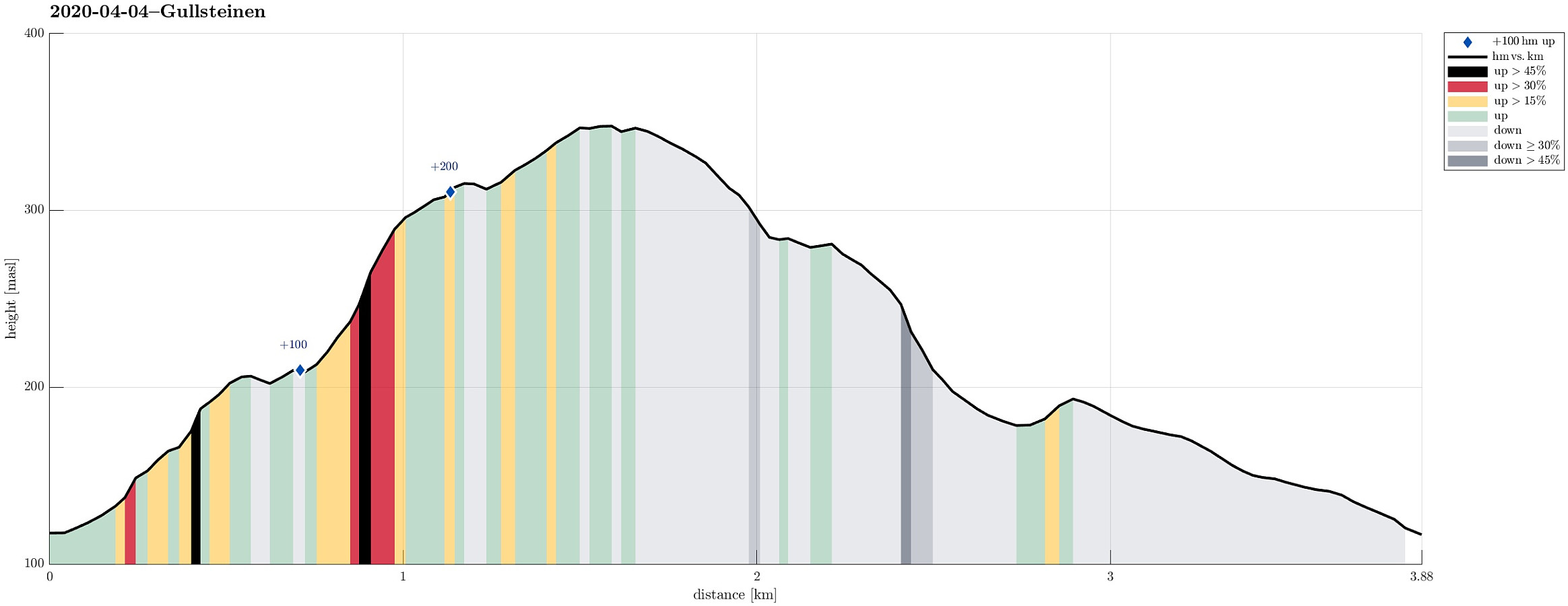 With a little bit of time left, we decided to make a short detour across Gullsteinen. We parked along Nils Langhelles vei and walked up one of its steep side roads first. Near house #22, we had come to the end of this side road. Fortunately, it was possible to ascend up towards the next side road. From there, where this other side road makes a sharp turn to the south, it was then only a few meters, before a trail leaves to the left. Stepping up through the forest there, we first ascended a micro-hill south of Strutsefarmen. From there, we turned back to the trail, which leads up to the ridge between Gullsteinen and Løvstakken. Instead of following the trail, however, we decided to step up "through the wild" (and in the not all-too-deep snow). Lovely, to get out into some >>>
Sælskletten and Sælsfjellet on Tofterøy
- Date:
- 28.03.2020
- Characteristic:
- Hillwalk
- Duration:
- 2:00h
- Distance:
- 6.5km
 Another Saturday with a promise of cold but nice weather invited us to plan another hike near the North Atlantic, making this the third in a row, after our nice hike to Brotavarden from Telavåg and our excursion to Ternneset from Kausland . This time, our goal was to hike a little round on Tofterøy, far in the southwest of Sotra. After following road 555 southwards, we turned right (onto road 200 towards Tofterøy) and passed over the narrow bridge (Tofterøybrua), after first havig waited for two horses to finish their (partially stressed) passage over the bridge. :-) On Tofterøy, we then followed the road until we came close to Trælevika. There, just north of Storavatnet, we parked and started our hike. The first goal of our hike was Sælskletten in the southeast of where we had parked. In order to find the needed trailhead, we had to walk back along >>>
Ternneset from Kausland
- Date:
- 21.03.2020
- Characteristic:
- Hillwalk
- Duration:
- 3:15h
- Distance:
- 11.8km
 Once again, we aimed at using a nice weekend day for getting some fresh air. Since we will had fond memories of our recent hike to Brotavarden from Telavåg , we decided to once again aim for the outer islands. This time, we planned for a hike from Kausland, just a bit north of Glesvær. The idea was to connect to Goltasundet (from the east) and then hike out towards the North Altantic along it's northern shore. On Sotra, we headed towards Glesvær. Near Kausland, we then left Glesnesvegen to the right (west), before parking only a few hundreds of meters down this little side road. From there, we followed a very clear trail (more like a gravel road in the beginning), leading us westwards. Soon after, we approached Goltatjørna from its north. We first tried to round it on a "tight route", but soon understood >>>
Brotavarden from Telavåg
- Date:
- 14.03.2020
- Characteristic:
- Hillwalk
- Duration:
- 3:30h
- Distance:
- 11.8km
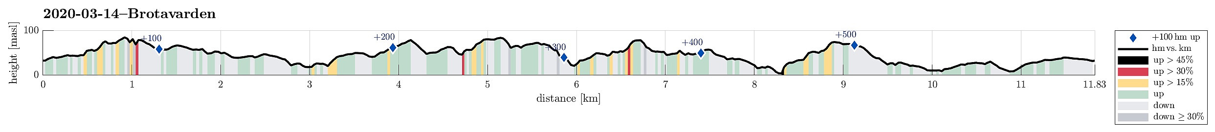 We really needed some fresh air (these times, you know) and since we were not really prepared for lots of snow and so, we decided to give the outer islands another try. After some consideration, Brotavarden was chosen as the hiking goal (with a start-point near Telavåg). We parked a few hundreds of meters before coming to Telavåg, near some soccer fields in the southeast of Telavåg. Just on the other side, we located the trail head and headed at once for our first intermediate goal, Nipa (in the east of Telavåg). Even though it's only a few meters up to the "top" of this cliff, one still has some nice views from there! Since winds were strong and temperatures were rather low, we did not stay there for any longer time, but continued (into the direction Brotavarden) immediately. >>>
Lyderhorn
- Date:
- 01.03.2020
- Characteristic:
- Hillwalk
- Duration:
- 1:30h
- Distance:
- 2.7km
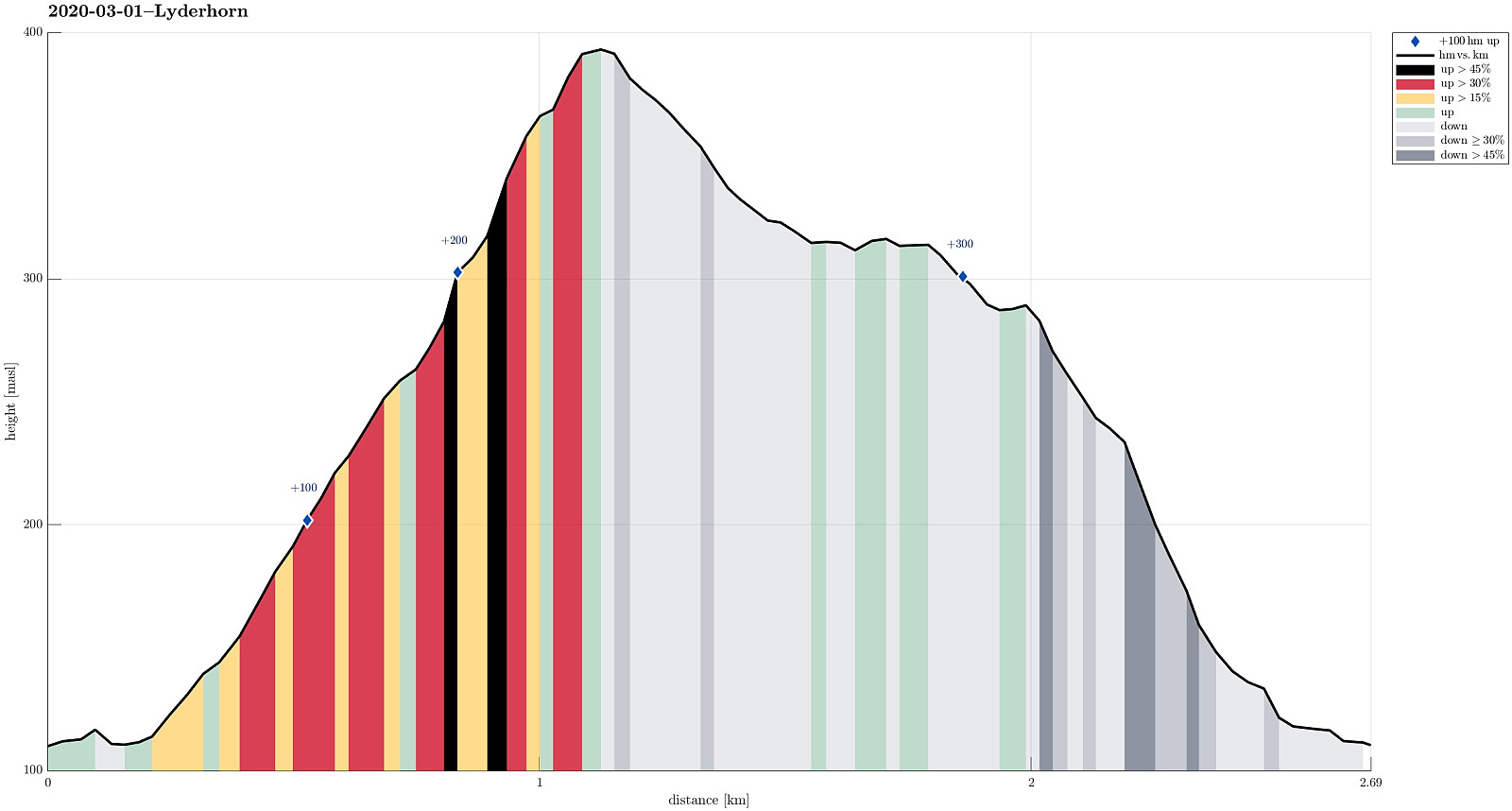 We needed some fresh air and since time was limited, we chose a nearby goal: Lyderhorn! We parked near Kjøkkelvik school and followed the main trail upwards from there (along a minor ridge which lead into southeastern direction, towards Små-Lyderhorn. From this intermediate point, it's then straight upwards (in northern direction up the steep side of Lyderhorn). Due to low temperatures (and limited time), we continued more or less directly across the top of Lyderhorn, aiming at the other, minor path down to where we started. As already once (at least) before, we missed, however, the point, where this minor path deviates from the main trail (towards north from Lyderhorn) -- the matter of fact that "everything" was covered by snow did not help to see, where this trail left. Something >>>
