
Nonhøyen etc. (23.08.2025)

Written by HHauser (Helwig Hauser)

| Start point | Varden (45m) |
|---|---|
| Endpoint | Varden (45m) |
| Characteristic | Bike trip - mixed |
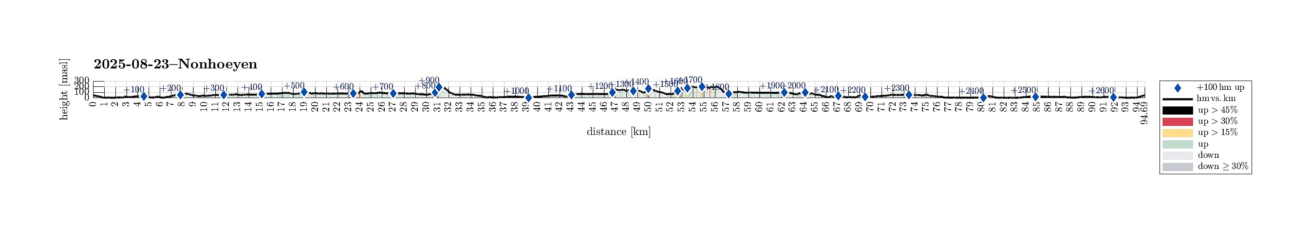
| Duration | 10h 00min |
| Distance | 94.7km |
| Vertical meters | 2,691m |
| GPS |
|
| Ascents | Eika (186m) | 23.08.2025 |
|---|---|---|
| Hestaberget (113m) | 23.08.2025 | |
| Høgehaugen (152m) | 23.08.2025 | |
| Jomfruhaugen (54m) | 23.08.2025 | |
| Kistehaugen (142m) | 23.08.2025 | |
| Klubben (154m) | 23.08.2025 | |
| Nonhøyen (236m) | 23.08.2025 | |
| Storeklubben (123m) | 23.08.2025 | |
| Tangelandsheiane Øst (200m) | 23.08.2025 | |
| Ørnatua (179m) | 23.08.2025 | |
| Visits of other PBEs | Arna stasjon (8m) | 23.08.2025 |
| Birken (65m) | 23.08.2025 | |
| Bryggen i Bergen (1m) | 23.08.2025 | |
| Espeland stasjon (70m) | 23.08.2025 | |
| Lyskasterbatteriet på Gaupåsen (143m) | 23.08.2025 | |
| Hestaberget utsiktspunkt (93m) | 23.08.2025 | |
| Holmen (5m) | 23.08.2025 | |
| Straume bro (5m) | 23.08.2025 | |
| Søylen p-lomme (85m) | 23.08.2025 | |
| Unnelandsvegen parkering (75m) | 23.08.2025 |
Trip Summary
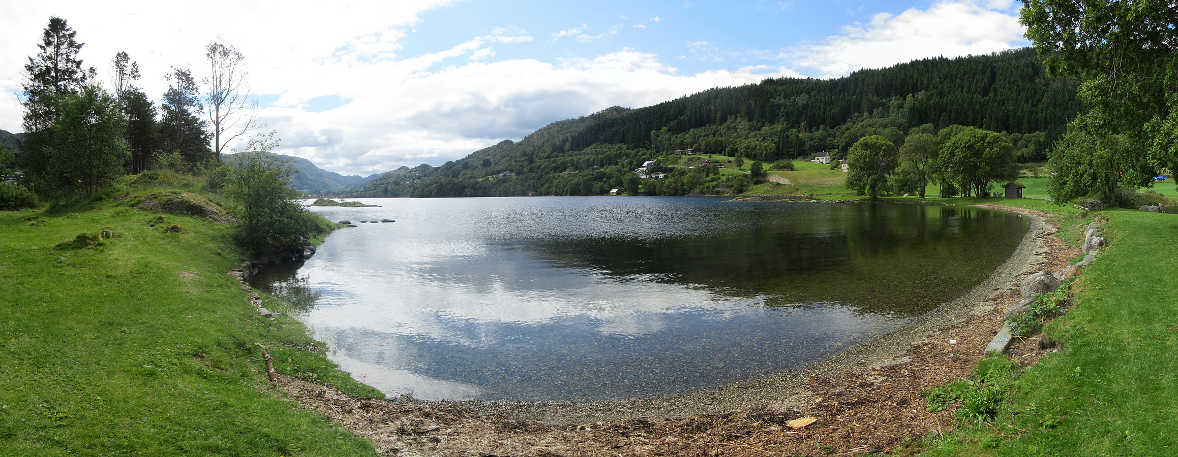
It looked like a promising Saturday and I wished to do another bike-hiking excursion to see a few places that I had not seen so far. I started by cycling via Straume to Søreide and then further into the direction of Lagunen. After cycling around Apeltunvatnet in its south, I connected to Tranevatnet and from there, after passing under E39, along Birkelandsvatnet to Dyngelandsvegen. This road brought me then to Helldal, where I eventually joined Hardangervegen to pass by Grimevatnet and then Søylevatnet. Cycling along this rather much used (and rather narrow) road is not exactly fun for the cyclist and one should only do it, when prepared for a bit of stress. Leaving Hardangervegen, I then continued along Unnelandsvegen, south of Haukelandsvatnet. At Storeklubben, I made my first short hiking intermezzo, ascending to the "top" of Storeklubben from the northeast side. When coming down again, I enjoyed some nice views across Haukelandsvatnet, both from a bit above as well as from the small bay between Storeklubben and Litleklubben. Back on my bike, I then followed Unnelandsvegen all the way to Espeland and from there, I then used the bike route into the direction of Arna. From Skaffamyrane, I then wished to do my second hiking stretch: up to Tangelandsheiane. On the map, I had seen that a trail would begin after house #63, but a person there refused me to get through to the trail (instead sending me off into a direction where no trail head was to be found). I thus used a different stretch to get behind the houses (and into the wild). Instead of finding a trail, then, I decided to "simply" ascend to Tangelandsheiane dirrettissima. While this worked, i.e., I made it all the way up, I sure cannot recommend this access route (it's a bit too wild, with rather pesty vegetation along most of this route, and some stretches, where I needed to use my hands, also). As a bonus, at least, I got to see a viper, hurrying away from me through the grass! :-) Once on the "top" of Tangelandsheiane, I enjoyed some nice views, both into the direction of Vidden, as well as towards Skåldalsfjellet. Back down, I then followed the trail, which I had initially considered. In most parts, this trail was easy to find, even though it did not look like being used a terrible lot. Back on my bike, again, I then head towards Arna and from there further northwards into the direction of Ytre Arna. This gave me the nice opportunity to stop at Holmen and have a look. Holmen looks like a nice place, where one could also spend some time, even with some swimming, on a nice summer day. Instead, I mounted my bike, again, in order to get closer to my next hiking adventure at Gaupås. To visit the hills in the north of Gaupås, I first cycled around it, and then a bit up Hetlebakkvegen. There, I found a very convenient trail head (more like the start/end of a tractor road), which quickly brought me over to Gamlesetra in the north of Klubben. From there, it then was only a few minutes to get to the actual top of Klubben. Hiking further southwards from there, I then made it soon to Høgehaugen. South of Høgehaugen, I first followed a trail with the goal to connect to Kistehaugen. About half way through, however, I could not see any further trail. Still, making it to Kistehaugen via its northern ridge was straight-forward. Initially, I had some small hopes to maybe catch a view southwards (across Beitelsvatnet) from Kistehaugen, but all views I found were very limited because of the trees. Next, I headed northwards, again, to take a look a the remains of some WWII constructions. More like an acutal place with historic significance, it looked to me like the camp of people from nearby, however. My goal, then, was to find a connection to Eika in the north of Vikane. My map study did not reveal any clear trails, however, so I was prepared for some more stepping through vegetation. :-) Up to the point, where I crossed the first of two southeastwards running little streams, I actually followed (mostly) a trail. From there, however, it then was mostly to (maybe) identify from deer tracks, if at all. Even though I tried to look out for some useful trails, I eventually made it all the way up to Eika without finding anything major. Even for the descent in westward direction, to get back to Hetlebakkvegen, I only found a trail half-way down from Eika. I still made it back down without stumbling and thus remounted my bike very soon again. It would not be a longer ride, though, because I had plans on the other side of Blinde: first Ørnatua and then, via the ridge that extends in parallel to E16 in its northeast, to Nonhøyen. After slipping through a tunnel underneath E16 in the west of Blinde, I quickly completed my visit to Ørnatua (not really exciting, though). After getting back down to Bykleiva, I then found a trail, which would bring me onto the ridge towards Nonhøyen. Following the ridge was then nice (and on a good trail!). On Nonhøyen, I then considered very brielfy to also visit its second "top" in the west, but soon decided against it. Instead, I head back to my bike (again via the ridge). Near Tanndalen, I then found a good way to descend back down to the tunnel through E16. With quite some kilometers in my legs, already, I then started my return-trip via Åsane. Near Griggastemma, however, I thought that I'd use the opportunity to include a short visit to Hestaberget. Somehow, however, I had did not recall the geography around Hestaberget all that well, and thus cycled up to Åstveittunet (a bit too far south). Only after having stepped up to the local hill-top, I understood that I was in the wrong place. :-) I thus found my way through the "depths" south of Hestaberget and then up to this hill from its southern side. This brought me first to a nice vistapoint in the west of the "top" of Hestaberget. I then crossed Hestaberget, connecting to Blådalen, from where it wasn't a long walk back to my bike. Before completing my trip, I also wished to pay a quick visit to Nedre Åstveit and Jomfruhaugen. After biking down to Nedre Åstveit, I first did not find a good access route to Jomfruhaugen. After a bit of back and forth, I then, however, found my way through to Åstveitveien. After walking around the lower area, which looked like a fancy garden to me, I then used a rather direct access route to get further up to Jomfruhaugen. Half way up, I then came to a gravel road, which I then followed to the "top", which offers some very nice views across Eidsvågen. On my way down, I the followed the gravel road "all the way down". Only then, I saw a sign which informed me that all of Jomfruhaugen was a private park and that access should be agreed upon ahead of time. Since I did not see anyone there, I left the park and thought that it was alright. I then wished to connect to Eidsvåg and thus headed towards Vikedalen. To get through there, was partially on a hiking trail, requiring me to push my bike. In Vikedalen, I then got to Ervikveien. Again, it was not fully clear to me, how to interpret the situation, but I then thought that it's more like an entry to a park than anything else. Since everything was open, I decided to push my bike up Ervikveien. Once a bit further southeast, I ended up in an area at Ervikbukta, which really looked very nice. Eventually, I made it back to the normal road, to continue my bike-trip back to Bergen around Eidsvågneset. Given the roughly 9h that I was out and pedalling/hiking, already, I included a stop in Bergen to refill my energies a little. After all, one needs to eat and drink every now and then! :-) Eventually, after getting back to Fyllingsdalen, I clearly recognized that it had been a rather long day with quite some kilometers and also quite some height meters! :-)
Photos
Selected photos are available as Google photo album.
Useful Resources
See also the related FB-page Hiking around Bergen, Norway.


User comments