
Vikanuten (02.08.2024)

Written by HHauser (Helwig Hauser)

| Start point | Renndalen P (50m) |
|---|---|
| Endpoint | Renndalen P (50m) |
| Characteristic | Hike |
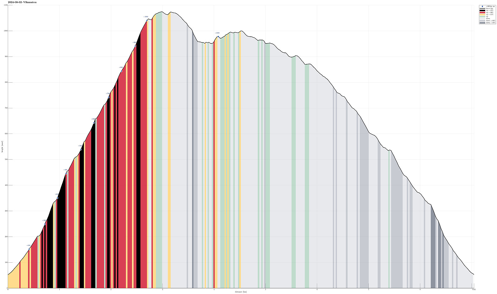
| Duration | 5h 30min |
| Distance | 9.1km |
| Vertical meters | 1,177m |
| GPS |
|
| Ascents | Vikanuten (1,078m) | 02.08.2024 |
|---|---|---|
| Vikanuten trigpunkt (1,065m) | 02.08.2024 | |
| Visits of other PBEs | Fjellstølen Jondal (600m) | 02.08.2024 |
| Sætveit parkering (52m) | 02.08.2024 |
Trip Summary
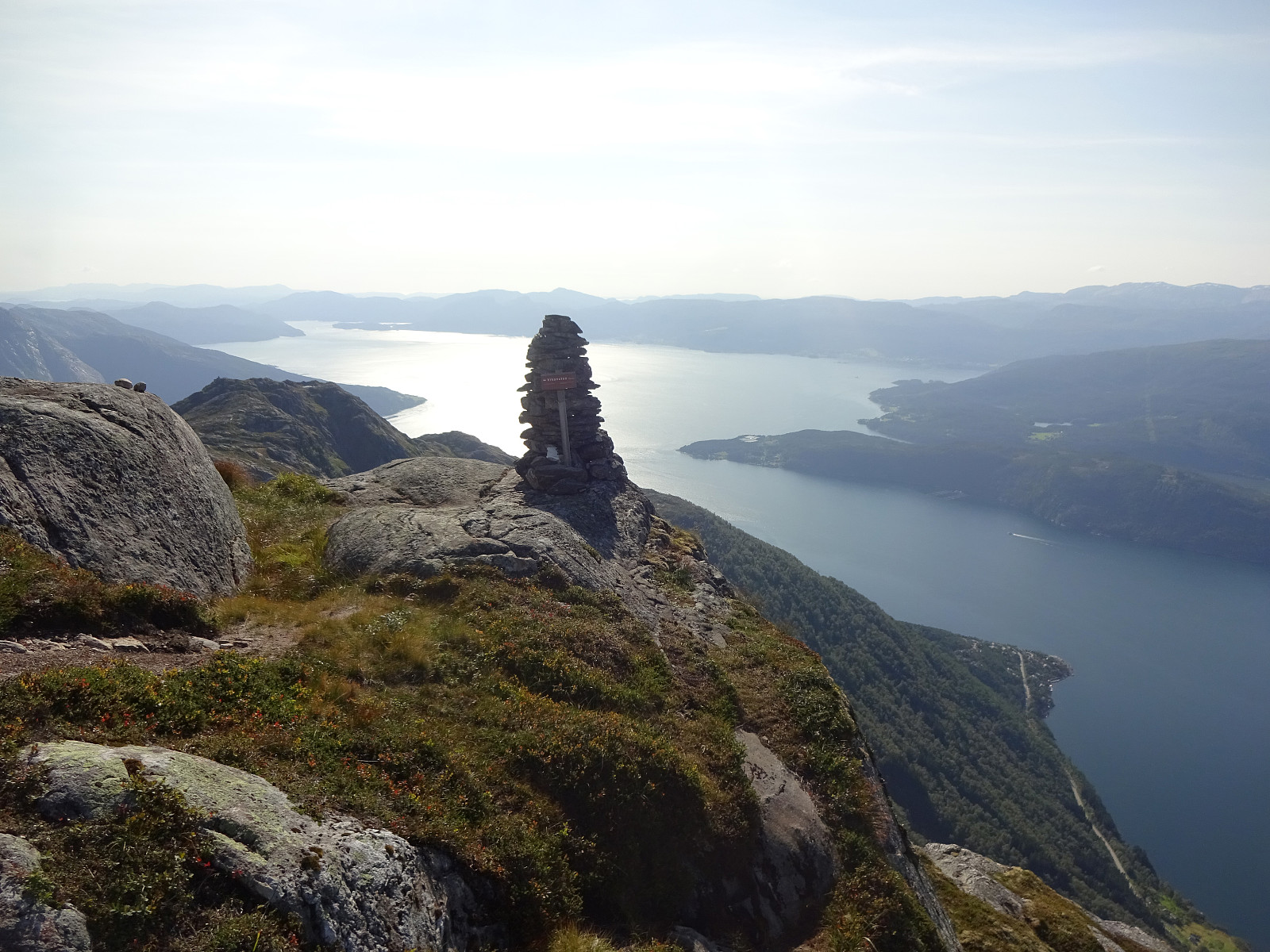
We left work early on this Friday and managed to start hiking around 15h15 right next to road #49 in the southwest of Jondal, where Renndalen comes down from Vikanuten. We followed the very well marked trail upwards, first on the east-side of Renndalen. At about 200masl, we crossed Gjelet to the western side of the valley, continuing our (steep) ascent to Vikanuten then this side. The trail upwards is well-marked and easy to find -- it's definitely steep, but no climbing is necessary (near the top, a few times it is helpful to use a hand in addition for additional stability, though). Especially once above the tree line (maybe around 650masl), one can enjoy marvelous views across Hardangerfjorden from this ascent. Roughly 1050masl, one finds a nice cairn which is marking a particularly nice vista-point. From there, it is then only a few more height meters up before reaching the actual top(s) of Vikanuten. From there, one then also has nice views into the other direction, in particular towards Folgefonna. After enjoying the views briefly, we decided to take a look at two smaller lakes in the southeast of Vikanuten's top. The "main valley" between "the two tops" of Vikanuten offered a steep but very reasonable way down to these lakes. After first stepping past the larger of the lakes, we aimed to connect to the smaller, also, a bit further to the northeast. To get there, we surrounded the little hill between the two lakes in its south, entering another small valley that brought us back up to the smaller lake. After a nice break right next to this small lake, we then started our traverse into the direction of Fjellstøl. To get there, we basically followed the 1000masl height line (approximately) in northern/northeastern direction. Crossing the heights of Vikanuten this way was very nice indeed, also offering some views into the direction of Breisete and Jondalstjørni. After coming by Kroktjørni, we soon reconnected with the main trail, coming down from Vikanuten along a more western route. This trail then brought us down to Fjellstøl in a "straight-forward" manner. From Fjellstøl, we then followed the well-marked main trail down to where we had started our hike earlier. All in all, a really nice hike with lots of wonderful views!
Photos
Selected photos are available as Google photo album.
Useful Resources
See also the related FB-page Hiking around Bergen, Norway.
Petter Bjørstad has a useful page about Vikanuten and also web page WestCoastPeaks.com provides useful information about Vikanuten.
Web page UT.no from the Norwegian Trekking Association recommends a similar hike.


User comments