
Hauggjelsvarden from Grimen (26.11.2022)

Written by HHauser (Helwig Hauser)

| Start point | Hardangervegen (75m) |
|---|---|
| Endpoint | Hardangervegen (75m) |
| Characteristic | Hike |
| Duration | 3h 30min |
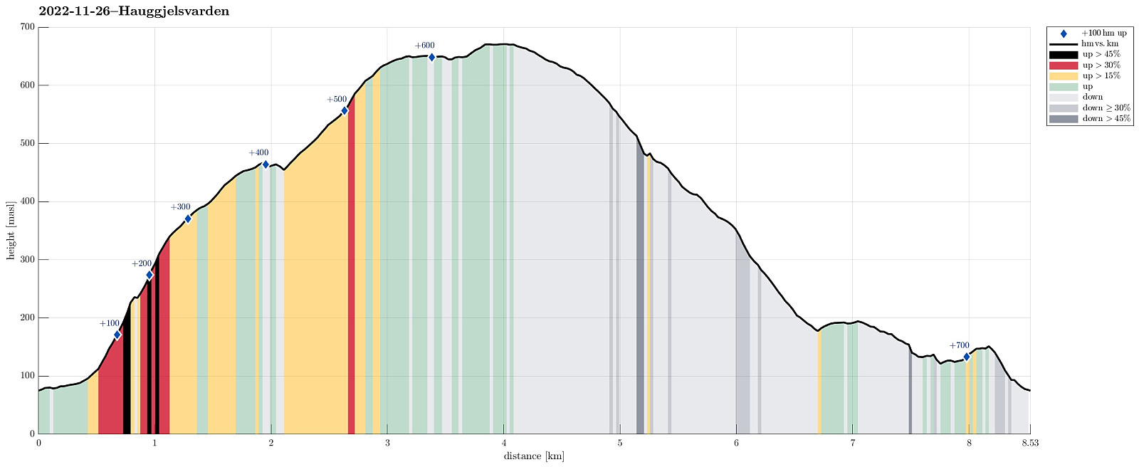
| Distance | 8.5km |
| Vertical meters | 724m |
| GPS |
|
| Ascents | Byfjellenes høyeste punkt (674m) | 26.11.2022 |
|---|---|---|
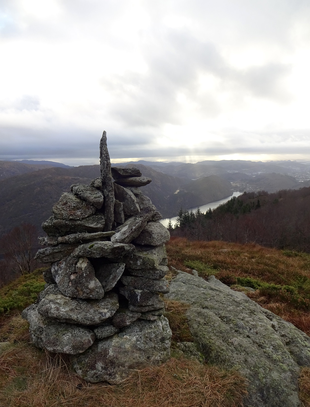
| Hauggjelsvarden (673m) | 26.11.2022 | |
| Ørnatua (157m) | 26.11.2022 | |
| Visits of other PBEs | Erdalsvarden (458m) | 26.11.2022 |
| Grytebakkbrua (180m) | 26.11.2022 | |
| Haukelandsvarden (640m) | 26.11.2022 | |
| Valhal (645m) | 26.11.2022 |
Trip Summary
This Saturday was predicted to be the better hiking day of the weekend with clouds and some wind on the menu. The idea for the day was to ascend to Vidden from Erdalen near Grimevatnet. We started near the camping site at Grimen, crossing over Hardangervegen to get onto Erdalsvegen. After walking along Erdalsvegen for only about 200m, we turned left (exit towards the houses 12, 14, and 20), crossed the railtrack, and started our ascent into Gaulgjelet (steeply up on the eastern side of the stream). At about 125masl, we had to navigate around/over some rocks to continue in parallel to the stream. In retrospect, we got the impression that this could have been avoided by starting on the other, western side of the stream, maybe near houses 244 and 246 on Hardangervegen, and then crossing over to the eastern side of the stream a bit below 150masl (it looked as if a simple trail came across the stream there). From there, then, it was straight forward to ascend upwards (we even had the impression that previously this ascent was a marked though simple trail). Quickly, we stepped up to about 250masl, where we got the impression that the former trail possibly crossed the stream to the other side again. Since we wished to stay on the southeastern side, we instead ascended to the ridge in the southeast of Gaulfjelet (this part was significantly steep, but without any real difficulties). Once on the ridge, it was then nice and enjoyable to continue further upwards (in northeastern direction). A bit below 350masl, we then crossed a power line, which comes down there from the northwest, continuing further down towards Åsen on the other side of Erdalen. The terrain also became less steep further upwards (and also more wet). At about 450masl, we started to enjoy the first panoramic views, espcially towards the south. Shortly after, a quick detour was necessary to pay Erdalsvarden a short visit, also enjoying the new views from there. Continuing further upwards from there was then easy and nice (even though we got more and more exposed to some rather sharp and non-warm winds the further up we got). At about 650masl, we then felt like up on Vidden, starting our traverse towards Hauggjelsvarden, which kind of marked the turn-around point on this hike. After paying the cairns on Hauggjelsvarden a short visit, we immediately started our descent back to Erdalen -- the wind on top of Vidden simply did not invite us for any mentionable break. Heading southwards from Hauggjelsvarden, we then joined Jubileumsstien, following it downwards for a good stretch. Just a bit below 525masl, we then forked off from Jubileaumsstien, following a sign towards Brattland Camping. After descending a bit into western direction, we conveniently crossed over Grytebakkelva (at about 475masl), continuing our descend on the other side, still following the occasional signs towards Brattland Camping. Even though we had not seen this trail on the map, when preparing for the hike in advance, it still did not come as a perfect surprise -- if no trail had been there from before, likely someone would start making one there anyway! Even though a bit wet and slippery at times, we still found this trail helpful and convenient to quickly descend towards Erdalen (down Gråsmoglia and via Gamlakvilet). At about 180masl, we then crossed over a local saddle point, where likely in earlier days the post road through Erdalen came up and over into the direction of Brattland. To continue further in the direction of Grimen, we started following a trail that promised to extend along the ridge in the southeast of Erdalen. And, yes, it is nice and convenient to hike over this ridge (via Åsen in the southeast of the highest houses in Erdalen and further down via Ospåsen and Ørnatua). At the "very end" of this long ridge, where also a simple power line crosses over, we then descended towards Hardangervegen in western direction. All in all, this hike was simpler than originally expected -- clearly, ascending to Vidden from Erdal is "a thing" and can be done in a nice way without serious challenges. :-)
Photos
Selected photos are available as Google photo album.
Useful Resources
See also the related FB-page Hiking around Bergen, Norway.
Web page WestCoastPeaks.com provides useful information about Haugavarden, Ulriken, Storfjellet, and Landåsfjellet
and also Petter Bjørstad has a useful page about Ulriken.


User comments