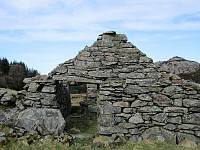
Brotavarden from Kallestad (10.03.2019)

Written by HHauser (Helwig Hauser)

| Start point | Kallestad (40m) |
|---|---|
| Endpoint | Kallestad (40m) |
| Characteristic | Hillwalk |
| Duration | 2h 45min |
| Distance | 7.7km |
| Vertical meters | 488m |
| GPS |
|
| Ascents | Brotavarden (87m) | 10.03.2019 |
|---|---|---|
| Ryggjastykket (74m) | 10.03.2019 | |
| Skjenhaugen (90m) | 10.03.2019 |

Trip Summary
I took the car to Sotra and there to Kallestad, leaving the road 555 at Trengereid. Right next to Sjoartjørna, I found the sharp turn to the left (and up to Kallestad), even though there wasn't really a street sign to see. I then parked next to Kallestad Grendahus and started my hike from there (first still on the road in western direction and between some houses). Soon, I left Kallestad behind and began my hike through wild Sotra. :-) When crossing over a meadow (south of Stølstjørna, still very near to Kallestad), I failed to see, where the trail continued (a bit further north of where I went). So, instead of hiking along the trail, I ended up on Skjenhaugen, enjoying the view from up there! I then continued (parallel to the trail) further in western direction (towards Kjereidet). My progress was OK, even though I had to navigate around some cliffs. When already close to Kjereidet, I decided to reconnect with the trail, having seen it further down and in parallel to my trajectory. Due to some non-negligible cliffs right east of Kjereidet, it quickly became a question of where to get down to the trail. Fortunately, I found an OK opportunity (still quite steep and at least two larger steps down). Once on the trail, progress was obviously easy, again. Very near to the sea, a convenient bridge is appreciated to get to the other side. Moreover, some stairs help then on the other side to get up onto a major, east-facing cliff. One above the cliff, however, progress is straight-forward and easy, again. More or less exactly there, where the trail crosses over the next saddle, I left the trail, again, and headed to Ryggjastykket, enjoying some very nice views from there. Then, to get to Brotet, I tried a "shortcut" (more or less in western direction from Ryggjastykket). The descent required some careful stepping and halfway down I ended up on some boggy terrain. Without all landscape details in mind, I gave it a try and descended almost all the way down to the sea at Brotet. Then, however, it became clear that I was too far north and that I could not traverse the steep cliff side there. Thus, I climbed back up and crossed over to the trail this way. Once back on the trail, I followed it for a while, until I decided to make a short detour down to the sea at Brotet (but now at the other side). After taking some photos, I went back to the trail and followed it up to Brotavarden. From there, after some additional photos, I returned along the trail to Kallestad.
Photos
Selected photos are available as Google photo album.
Useful Resources
See also the related FB-page Hiking around Bergen, Norway.


User comments