
Sæterfjellet on a wonderful winter day (28.10.2018)

Written by HHauser (Helwig Hauser)

| Start point | Borgaholmane (4m) |
|---|---|
| Endpoint | Borgaholmane (4m) |
| Characteristic | Hillwalk |
| Duration | 7h 00min |
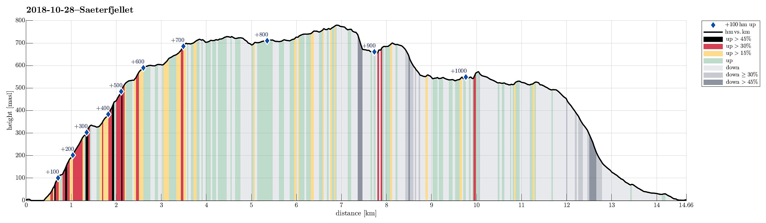
| Distance | 14.7km |
| Vertical meters | 1,082m |
| GPS |
|
| Ascents | Såta (703m) | 28.10.2018 |
|---|---|---|
| Sæterfjellet (782m) | 28.10.2018 |
Note that this hike is maybe better suited for experienced hikers (it's comparably long, mostly without a path, and some parts are very steep.
Trip Summary
We drove from Bergen northwards on E39, continuing further in the direction of Førde after Knarvik. Right before entering Eikefettunnelen, we left E39 and continued on road 570 in northern direction. After coming by Dyrdalen, we soon reached Kjekallevågen and bridge over it. Right afterwards, on Borgaholmane, we parked and started our hike.
Såta
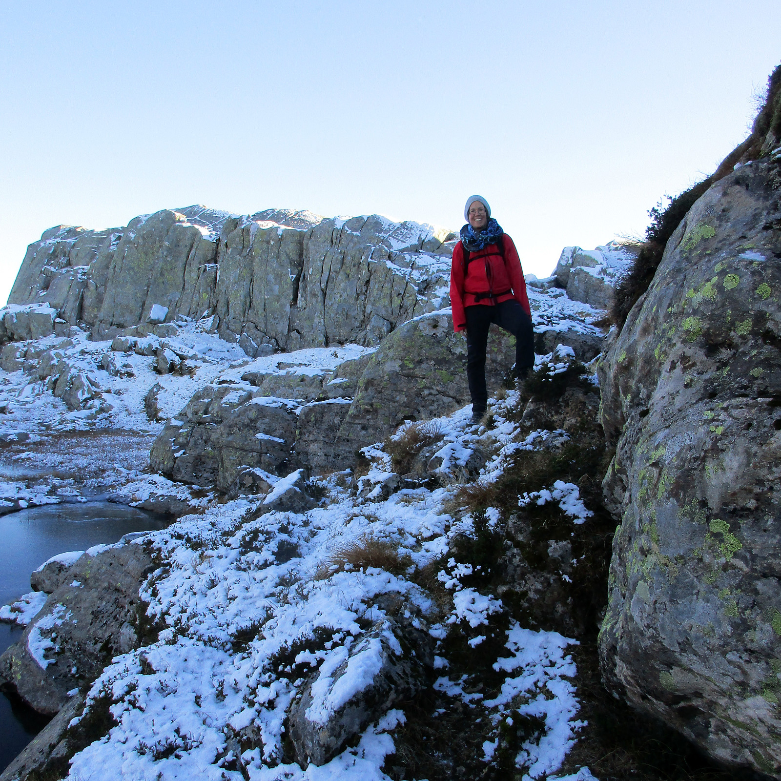
To start, we first crossed the bridge again (now per pedes and in southern direction) and headed towards Langeneset. At exactly the point, where the bridge ends, we left the road and started our ascent to Såta, stepping up a long ridge (south of Rasmusdalen), leading up to Gamlesetra, etc. The first check-point along this route is a point at about 115mosl, where the power line, which comes southwards across Kjekallevågen, makes a turn so that it then crosses Austfjorden (in southwestern direction) from there. Continuing further up the ridge, hiking was unexpectedly easy (one could have imagined a path even, every now and then!). At about 300mosl, one comes by the ruins of some older construction (a simple shelter for shepherds, probably) and the terrain flattens out a little (at least in southeastern direction; towards the northeast and towards the southwest, it's actually very steep). This somewhat flatter stretch brings on around some steep and high cliffs (overhead) and to a side of the mountain, which is easier (not 100% easy, though) to climb. There, now heading steeply upwards in northeastern direction, we continued towards Svartatjørna (while not seeing it yet from below). Soon after, we reached Svartatjørna and with that the higher parts of Såta (not steep anymore). Before heading towards the top of Såta, we first made a little detour towards Askarlia (in order to enjoy at least one view down the very steep mountain sides there, towards Kjekallevågen). As soon as we crossed over the edge of Såta (near Svartatjørna), we clearly recognized that we also had left a somewhat more temperate air near the fjord, continuing through pretty cold wind and a bit of snow on the ground.
Sæterfjellet
From Såta, we continued our round with Sæterfjellet as the next goal. In order to get there, we needed to get on the other side of Krokavassdalen and the plan was to cross over near Krokavatnet. We thus headed first in eastern direction from Såta (towards the northern end of Krokavatnet). Once we got close, the terrain became more challenging and some careful consideration was necessary to avoid getting stuck. After a bit of back and forth, we then found a place, where we could get down into Krokavassdalen (just north of Krokavatnet) and cross over. On the other side (southwest of Sæterfjellet), hiking got easy again (first). Without any major challenges, we hiked swiftly in northeastern direction (towards Sæterfjellet). Once we got closer to Sæterfjellet, however, the terrain got more rigged, again, and landscape-reading was necessary to find a possible route to the top (not really difficult, though).
Back via Langevatnet
From Sæterfjellet, we wanted to cross over (in northern direction) to Båtevassdalen so that we could then continue to Langevatnet and from there further west and down. After only a short stretch northwards on Sæterfjellet, we reached the northern "edge" of the mountain, understanding that it was very steep on its northern side (much more than thought!). At the place that we first reached, it simply was impossible to descend. Thus, we started first to proceed along "the edge" (in western direction) in order to find a suitable spot for a descent. After a bit, we found a narrow and steep couloir that lead downwards to some lakes underneath. After some consideration, we decided to try a descent through this couloir (fully aware that we quite possibly would have to climb back up, if it should turn out too difficult). The snow and ice did not make descending easier, so we stepped downwards very carefully and slowly. About half-way through, we came to a point, where we could not see further down, because the terrain got even steeper. At this point, it was very unclear, whether stepping further down would work out. Luckily, we found a spot (very close to the cliff wall on the left/west), where proceeding was possible and after carefully continuing our descent, we finally ended up amid the lakes which we had seen from above. Relieved, we continued towards west (and a slightly larger lake). There, a new challenge emerged: Heading north on the eastern side of the lake, we again ended up in some very steep terrain (now traversing it) and a little bit of careful climbing was necessary to proceed. Also, it turned out to be impossible to continue further westwards on the northern side of the lake (due to a vertical cliff that is simply too high). Thus, we continued northwards (and upwards), ending up on Steingarsnipa (between Sæterfjellet and Båtevassdalen). On this ridge, we then continued in western direction until we found another couloir (descending northwards into Båtevassdalen), which appeared to allow a descent into Båtevassdalen. Even though also very steep, the descent through this couloir was much easier and comparably straight-forward. With little delay, we ended up in Båtevassdalen. There, however, we understood that we had accumulated way more time than thought for mastering the unexpected challenges and we were reminded of another hike, which we had done two years earlier (also in October, then up to Tveitakvitingen), where we had ended up in the dark before reaching our car. Fortunately, this time, we were better prepared with some headlights in our backpacks! :-) Once in Båtevassdalen, we turned left (towards west) and continued towards Langevatnet, enjoying some dramatic views in the valley. In order to get by Langevatnet, we chose the southern side and learned that it is not exactly straight-forward to find the route (one needs to go up on the mountain-side south of Langevatnet quite a bit, every now and then, for finding a continuation. On the western end of Langevatnet, however, we finally appreciated a path emerging more clearly from the terrain. This path lead us quickly further west and to Dravlekupa. There, we misjudged the situation (we saw a hut on the other side and assumed that the path would run by this hut) and switched to the other, northern side of the stream. This lead us into a part, which was too far north (and would have connected to Langevassdalen). Soon we saw that the path, which we wanted to follow, was much further down and south of where we were. So we retreated (almost all the way back to the hut), before we reconnected with the path. From there on, however, it was then very simple to follow the path (south of Stemmetjørna and downwards next to Strandaelva), even though it had become quite dark already. After a short while hiking through the dark forest, we ended up at some houses at Einestranda. From them, instead of following the road, we took a shortcut (a forest road) that lead more directly down to Austfjordvegen. Once there, we simply followed the road back to our car.
Conclusion
Clearly, this hike will be remembered for long and this because of several reasons: (1) What a beautiful winter day?!!! Blue sky all day long, lots of sunlight; simple beautiful! :-) (2) Majestic mountain area next to a picturesque fjord; what more can one wish for?!!! (3) Some hiking challenges that were more exciting than anticipated! :-) (4) Another hike that ended up in the dark! This time, however, it was no problem at all (headlights are quite a treat in such a situation!).
Photos
Selected photos are available as Google photo album.
Useful Resources
See also the related FB-page Hiking around Bergen, Norway.


User comments