
Jordalsnuten from Jordalen (25.08.2018)

Written by HHauser (Helwig Hauser)

| Start point | Parking Jordalsnuten (450m) |
|---|---|
| Endpoint | Parking Jordalsnuten (450m) |
| Characteristic | Hillwalk |
| Duration | 3h 30min |
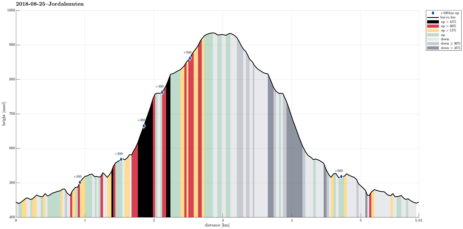
| Distance | 5.8km |
| Vertical meters | 644m |
| GPS |
|
| Ascents | Jordalsnuten (938m) | 25.08.2018 |
|---|---|---|
| Visits of other PBEs | Hyllandsskaret (844m) | 25.08.2018 |
| Jordalsnuten parkering (450m) | 25.08.2018 |
Trip Summary
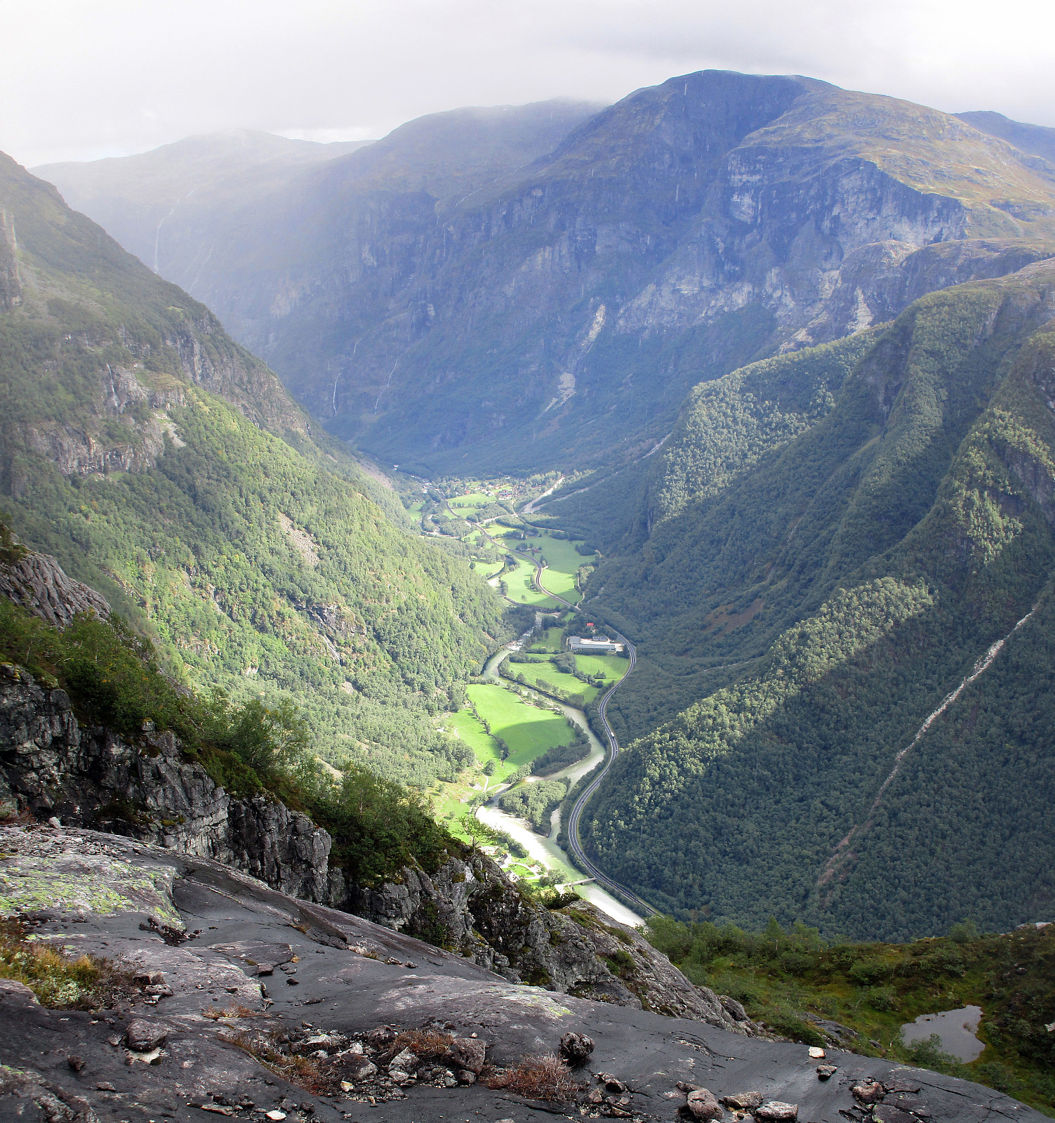
We took road E16 into direction of Gudvangen first and turned to the left (towards Jordalen) after descending into Nærøydalen below Stalheim. We then drove through the new tunnel (now on the eastern side of the valley) up to Jordalen. After leaving the tunnel, we crossed one bridge immediately, before parking the car just ahead of the next bridge. From there we hiked, first over the bridge to the other side of Jordalselvi (to its eastern side), then southwards along the steep eastern side of the valley (into the direction of Jordalsnuten), following a proper path (note that the trail head is not really easy to see; we needed a bit of searching until we found it). It's interesting, also, that the path leads first (more or less) horizontally (with quite a bit of up and down, though) out of the valley, before then turning left and upwards (steeply upwards!) in order to guide the hiker to Hyllandsskaret between Vardanosi (on the northeast) and Jordalsnuten (in the southwest). From there, Hyllandsskaret, one can enjoy outstanding views, both into Nærøydalen and also into Jordalen---definitely a place worth visiting! After looking for a short while, we continued the last (short) bit up to Jordalsnuten, where we walked over the round top a bit such that we could see in all directions (the weather was not that nice, when we were at the top, so we decided to descend immediately again). It's nevertheless rewarding, in a way, to stand on (the rather round and calm) top of this mountain, which is such an iconic view from below (from Stalheim as well as from other places) due to its sugar cone shape (another sugarloaf mountain!). After another short stop at Hyllandsskaret (maybe the best place along this hike), we descended back to our car following the same path that we had taken up before. All in all, this is a moderately demanding hike (the part "straight up" to Hyllandsskaret is indeed very steep!), which can be a very nice option in this wonderful Nærøyfjord-area, when not so much time is available!
Photos
Selected photos are available as Google photo album.
Useful Resources
See also the related FB-page Hiking around Bergen, Norway.
Web page WestCoastPeaks.com provides useful information about Jordalsnuten, Vardanosi, Solbjørgonipa, and Giljabotnnipa.


User comments