
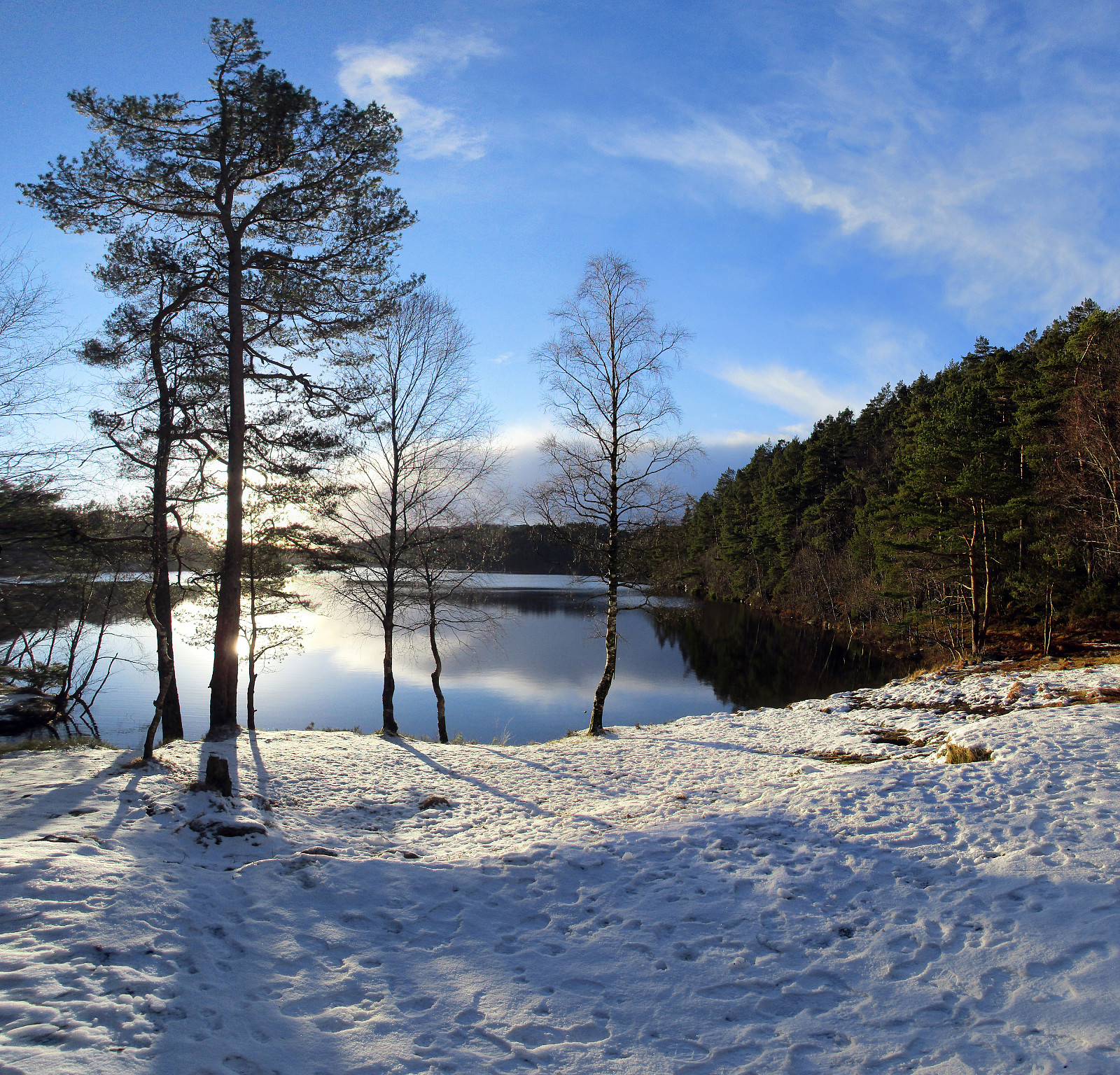
Svartaberget in nice winter sun (14.01.2017)

Written by HHauser (Helwig Hauser)

| Start point | Varden (45m) |
|---|---|
| Endpoint | Varden (45m) |
| Characteristic | Hillwalk |
| Duration | 3h 00min |
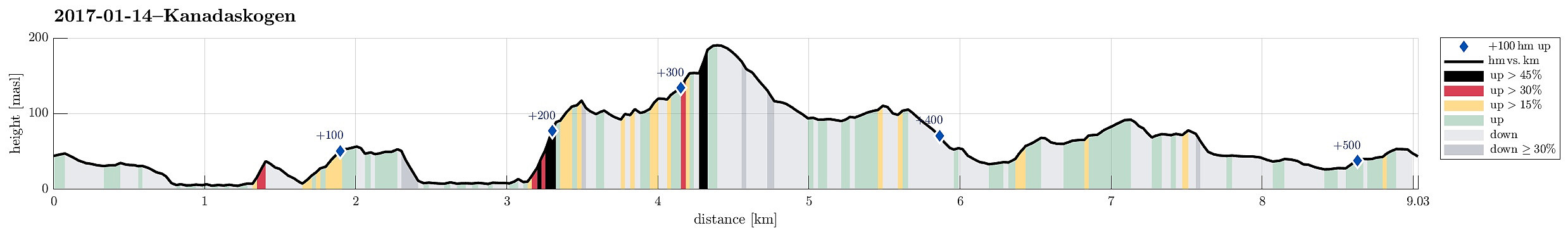
| Distance | 9.0km |
| Vertical meters | 518m |
| GPS |
|
| Ascents | Svartaberget (194m) | 14.01.2017 |
|---|---|---|
| Træshovden (119m) | 14.01.2017 | |
| Visits of other PBEs | Øst for Elvareidet (60m) | 14.01.2017 |
Trip Summary
We started in Varden and used Bregnestien to get close to Gjeddevatnet as soon as possible.
Along Gjeddevatnet and Bjørndalsvatnet
Once had descended to Gjeddevatnet (basically to the place, where occasionally some bath in warmer months), we continued along the water (in northward direction). We kept going along the water, passing by Skogadotten and Skaget until we reached Gjerdsvika. Before going further to Bjørndalsvatnet (over the heights southwest of Hesjaholtet), we first made a short visit to Fureneset (very nice in the winter sun!). We then crossed over the heights west of Hesjaholtet in order to connect to Bjørndalsvatnet. We came back down to the water basically directly west of the northern most block of Hesjaholtet and managed to continue along the water (even though there is a very steep cliff to its eastern side). This brought us to a nice place along Bjørndalsvatnet, close to the small island in this lake. We then continued further along the water until we reached the northernmost bay of Bjørndalsvatnet. This place is also very nice, with some ruins of a former building (a mill, maybe?).
Svartaberget
We then decided that we wanted to try out something new and so we continued to ascend to Træshovden (in northwestern direction) in an as-direct-as-possible manner (steep but well possible). From there, we continued in northern direction (towards Svartaberget), which brought us by Ravnestølen, where several houses enjoy a view over Kanadaskogen in eastern direction. We basically went (on their western side) around theses houses, which are oriented towards the east, up there, and got back into the forest right north of them. We managed to step upwards through a narrow and steep opening (just a few meters) and continued towards the heights right next to Ravnestølen, leading further upwards to Svartaberget. The path to Svartaberget is a bit east of the ridge and is straight forward to step up. Half-way up we stepped out to the ridge in order to enjoy a nice overview over Bjørndalspollen and its surrounding. We then made the remaining meters up to Svartaberget and enjoyed the view from its top very much. Stepping around its southern "corner", we also got a glimpse of Fyllingsdalen from there (unusual view!).
Back through Kanadaskogen
We then started to descend from Svartaberget, first along the path that we had taken up, but soon after heading more in eastern (than in southern) direction (more or less straight towards Svartatjørna). We found the path, which connects the saddle northeast of Svartaberget with Svartaberget and we took this path down, reaching the saddle soon after. At the saddle, we turned right (then in southeastern direction), stepping down to Svartatjørna from there. We followed the northern end of Svartatjørna and connected to Storamyra with this characteristic big bolder, resting high above it (on its eastern side). We then changed to a southern course (more or less into the direction of Storhovden, but without ascending to it, really). Instead, we used several small paths, west of Storhovden and Syningen, to get further south, into the direction of Hesjaholtet. After some hiking, we came very close to Krokatjørna, but instead of following the path along its western side, we walked upwards to a small ridge that connects more directly to the northern end of Hesjaholtet. Once back on the street, we basically walked back to Varden, crossing over the soccer fields in order to cut short some of this return walk.
Summary
All in all, this was a very nice winter day with sun and snow (clearly, not all winter days are like that in Bergen, Norway!).
Photos
Selected photos are available as Google photo album.
Useful Resources
See also the related FB-page Hiking around Bergen, Norway.
Web page TurStier.org describes a similar hike.


User comments