Archive - Date
Archive - Activity
-
Trip by foot (12)
- Glacier travel (1)
- Hike (1)
- Hillwalk (6)
- Jogging (4)
Peakbook-Friends
Collected lists

Langeskavltinden
- Date:
- 18.07.2025
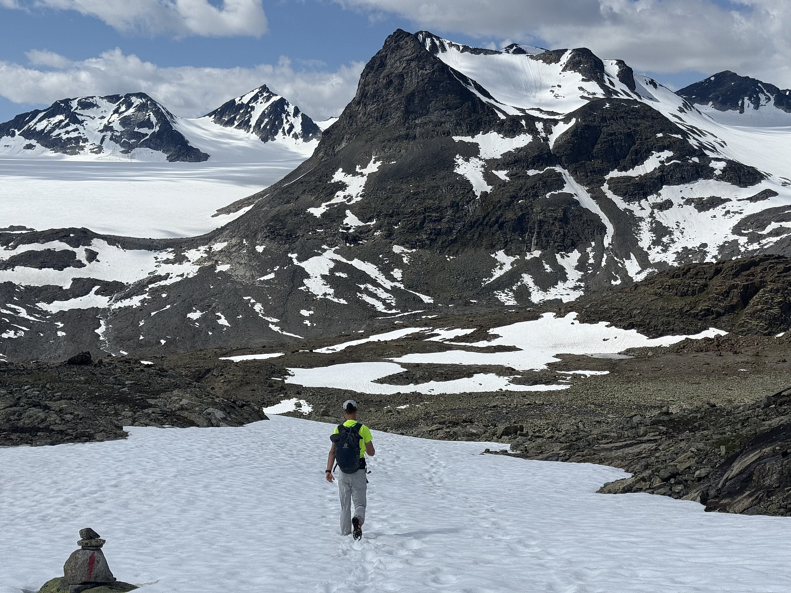
Another day of hot and sunny weather, bringing our streak of (mostly) good weather to nearly 3 weeks! Today was the last of 3 days near Tyin and we'd be travelling back to Lillehammer in the evening (and subsequently the UK, a few days later). We'd climbed Urdanostind 2 days prior but had aborted Falketind yesterday (a large snow bank near the 1291 lake made the route unsafe to pass); we were determined to actually make it up a top today, so opted with an easier looking tour Langeskavltinden. The route had already intrigued us as Langeskavltinden appeared on the map to protrude into a large glacier - its peak nearly surrounded by ice and this ice surrounded by gnarly mountains (including Urdanostind). We had some concern that progress on the 23km route might be slow as it was hard to assess >>>
Uranostind
- Date:
- 16.07.2025
- Characteristic:
- Glacier travel
- Duration:
- 6:00h
- Distance:
- 17.0km
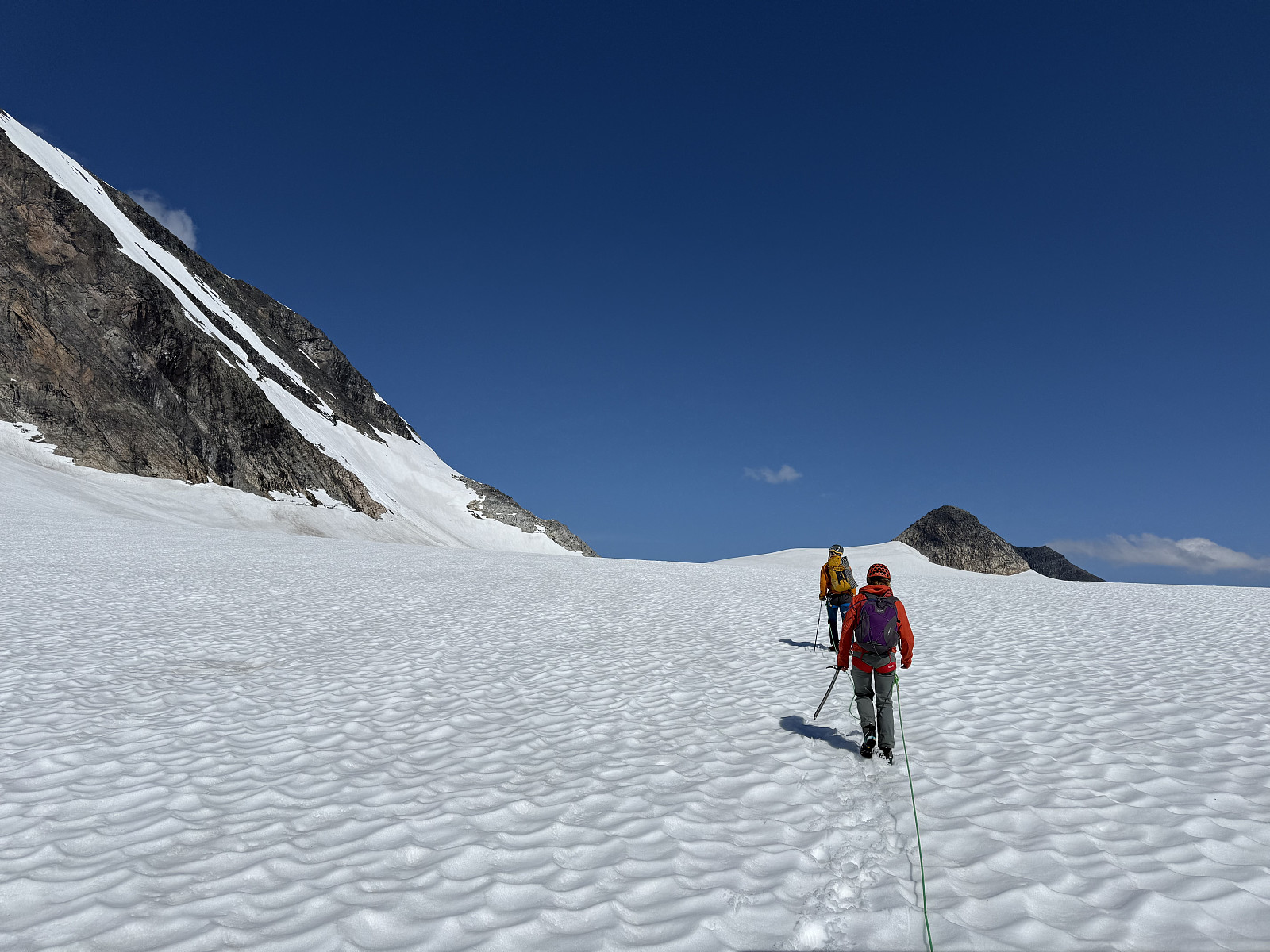 Coming from the U.K., neither Alice nor I have experience traversing glaciers. Given the two of us want to explore more of Norway, we decided to book a guide across one: so why not use this as an opportunity to climb one of Jotunheimen's most iconic peaks!
We woke near Otrovatnet and took the scenic drive along Tyin towards Tyinholmen Høyfjellsstuer, where we were scheduled to meet with our guide. The sky was clear, wind was light and Uranostind was glimmering, mirrored on the lake.
We met our guide, acquired our helmet, harness and ice axe and were introduced to a lovely Norwegian couple with whom we'd be sharing this tour. Alice gauged that they looked fit and active- a relief as we worried about how slow-going it could be in a guided group. Returning to our car, the guide escorted us down >>>
Coming from the U.K., neither Alice nor I have experience traversing glaciers. Given the two of us want to explore more of Norway, we decided to book a guide across one: so why not use this as an opportunity to climb one of Jotunheimen's most iconic peaks!
We woke near Otrovatnet and took the scenic drive along Tyin towards Tyinholmen Høyfjellsstuer, where we were scheduled to meet with our guide. The sky was clear, wind was light and Uranostind was glimmering, mirrored on the lake.
We met our guide, acquired our helmet, harness and ice axe and were introduced to a lovely Norwegian couple with whom we'd be sharing this tour. Alice gauged that they looked fit and active- a relief as we worried about how slow-going it could be in a guided group. Returning to our car, the guide escorted us down >>>
Kattanakken
- Date:
- 13.07.2025
- Characteristic:
- Hillwalk
- Duration:
- 6:00h
- Distance:
- 15.0km
 Since we first visited the region last September, Alice and I have felt a sense of awe around the Jostedalsbreen glacier. Back then we had hiked to Flatbrehytta and had looked down upon the cascading Flatbreen glacier, where we had spent at least two hours admiring its frightening beauty; even watching from afar as a large chunk crumbled down the icefall. We'd fancied getting close to Jostedalsbreen again, and bookmarked Kattanakken for our next visit.
We had arrived in Stryn the evening before and were set to enjoy two full days in the area. A heatwave had arrived, bringing daytime highs to the high-twenties in the valley- quite a contrast to where we were heading. Setting off from the huge carpark in Briksdalen, we skirted around the many tourists taking the short walk/buggy ride(!?) up to >>>
Since we first visited the region last September, Alice and I have felt a sense of awe around the Jostedalsbreen glacier. Back then we had hiked to Flatbrehytta and had looked down upon the cascading Flatbreen glacier, where we had spent at least two hours admiring its frightening beauty; even watching from afar as a large chunk crumbled down the icefall. We'd fancied getting close to Jostedalsbreen again, and bookmarked Kattanakken for our next visit.
We had arrived in Stryn the evening before and were set to enjoy two full days in the area. A heatwave had arrived, bringing daytime highs to the high-twenties in the valley- quite a contrast to where we were heading. Setting off from the huge carpark in Briksdalen, we skirted around the many tourists taking the short walk/buggy ride(!?) up to >>>
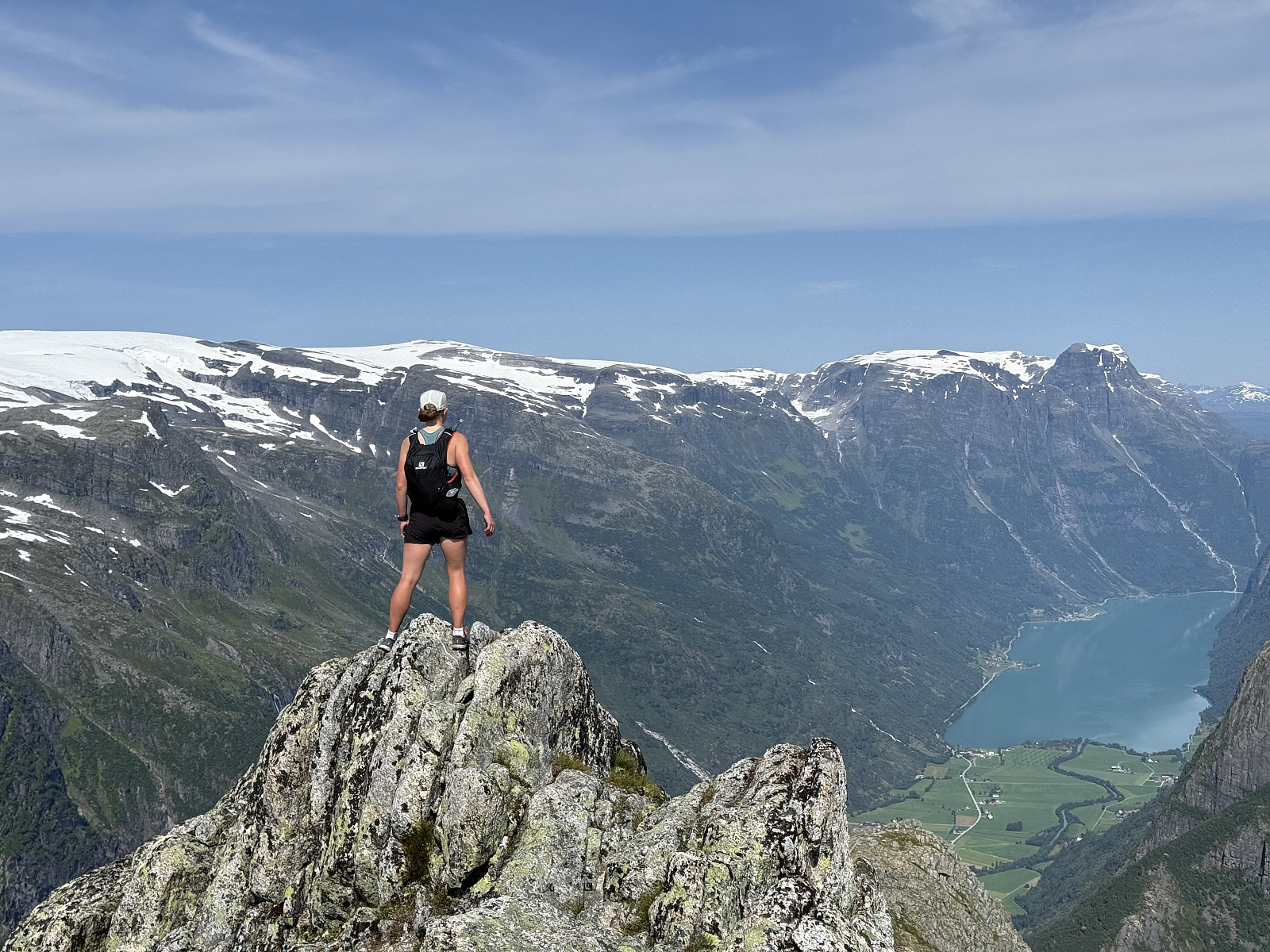
Besshøe (and back via Besseggen)
- Date:
- 11.07.2025
- Characteristic:
- Hike
- Duration:
- 7:00h
- Distance:
- 26.0km
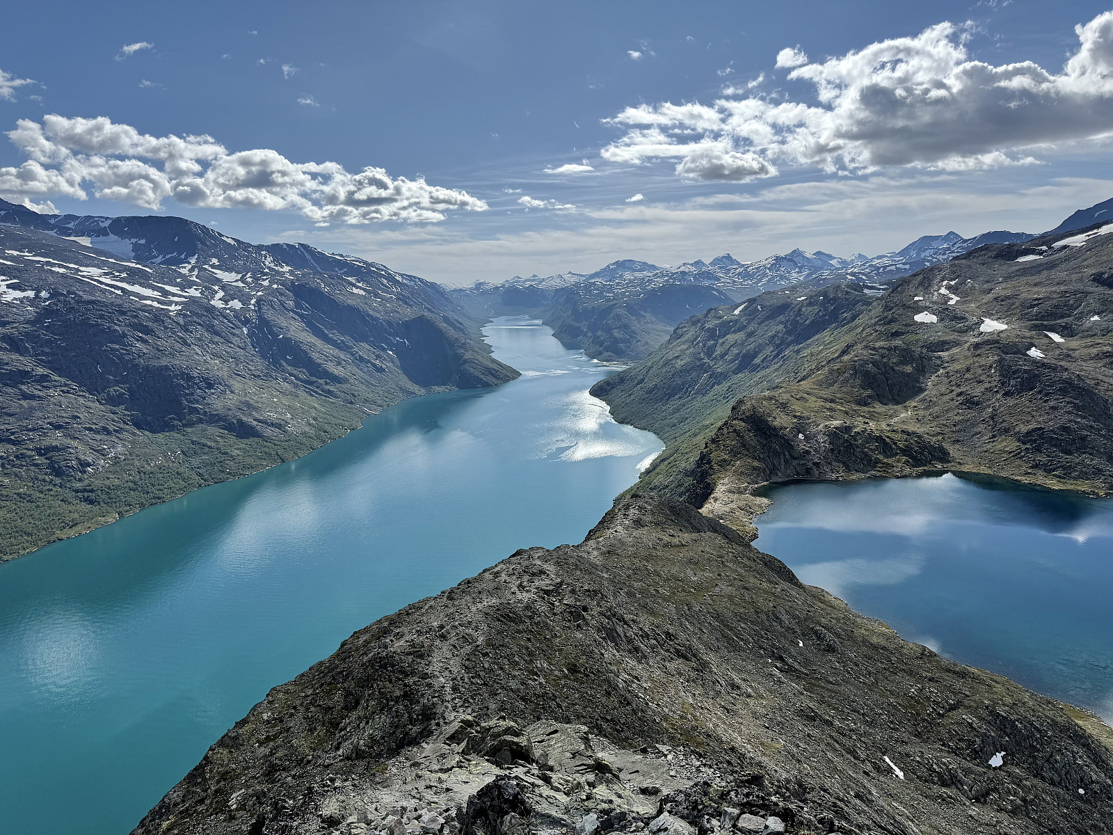 Alice and I first visited Norway in September of 2024, during which we hiked the infamous Besseggen hike, opting to save money by hiking around Bessvatnet, joining the tourist route half-way and following it back to Gjendesheim. At the time we had looked up Besshøe and made a mental note to return one day. Then, during this trip, we had taken the Gjendebåtene to Memurubu to hike Surtningssue and were reminded of this pledge. A few days later were arrived at Bessheim, with the idea of hiking Besshøe and returning via Besseggen.
It was another glorious day in Vågå with clear blue skies and light winds (I’m increasingly being told that this July was very out of the ordinary). We began from Bessheim at around 12:00, sweating it out up the 300m or so to Bessvatnet in the already intense heat. >>>
Alice and I first visited Norway in September of 2024, during which we hiked the infamous Besseggen hike, opting to save money by hiking around Bessvatnet, joining the tourist route half-way and following it back to Gjendesheim. At the time we had looked up Besshøe and made a mental note to return one day. Then, during this trip, we had taken the Gjendebåtene to Memurubu to hike Surtningssue and were reminded of this pledge. A few days later were arrived at Bessheim, with the idea of hiking Besshøe and returning via Besseggen.
It was another glorious day in Vågå with clear blue skies and light winds (I’m increasingly being told that this July was very out of the ordinary). We began from Bessheim at around 12:00, sweating it out up the 300m or so to Bessvatnet in the already intense heat. >>>
Rondslottet
- Date:
- 10.07.2025
- Characteristic:
- Jogging
- Duration:
- 5:00h
- Distance:
- 24.0km
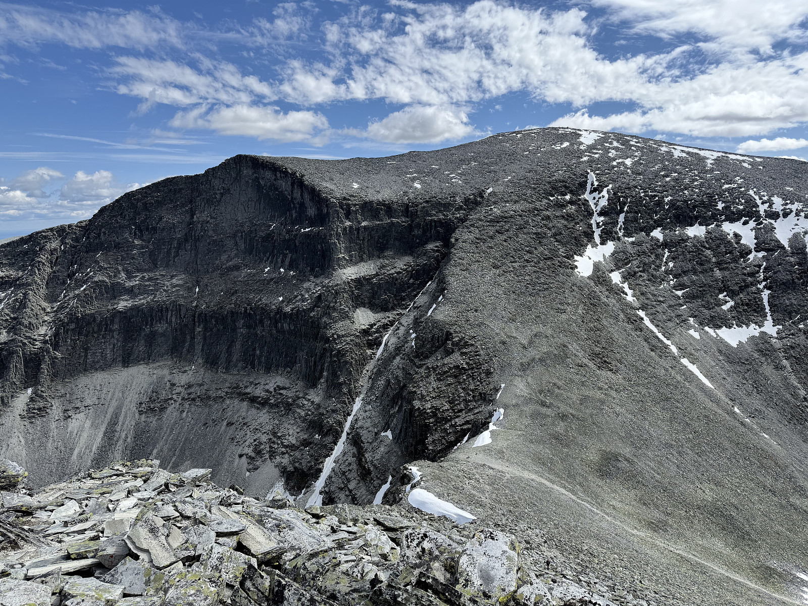 Being based in Vågåmo meant that we were essentially equidistant to Rondane and Jotunheimen, and up until this point, we'd spent most of our days exploring Jotunheimen. Fancying a change in terrain, we opted for a trip up Rondslottet. A heatwave had began to brew, it was bright, clear but oppressively hot. We'd observed that the afternoons tended to bring patchy cloud and secretly wished for the sun to go in today.
We drove from Vågåmo to Spranget, ascending through the forrest and onto open fell where the (now very much full) carpark is located. It is 6km from Spranget to Rondvassbu (where the climb officially starts) and this would ordinarily make for a long day out if it weren't for the bike-hire service offered by the DNT cabin. Here at Spranget you can hire a mountain bike for the 6km >>>
Being based in Vågåmo meant that we were essentially equidistant to Rondane and Jotunheimen, and up until this point, we'd spent most of our days exploring Jotunheimen. Fancying a change in terrain, we opted for a trip up Rondslottet. A heatwave had began to brew, it was bright, clear but oppressively hot. We'd observed that the afternoons tended to bring patchy cloud and secretly wished for the sun to go in today.
We drove from Vågåmo to Spranget, ascending through the forrest and onto open fell where the (now very much full) carpark is located. It is 6km from Spranget to Rondvassbu (where the climb officially starts) and this would ordinarily make for a long day out if it weren't for the bike-hire service offered by the DNT cabin. Here at Spranget you can hire a mountain bike for the 6km >>>
Store Smørstabbtinden
- Date:
- 09.07.2025
- Characteristic:
- Hillwalk
- Duration:
- 5:00h
- Distance:
- 14.0km
 Having climbed Surtningssue the day prior and with the fantastic conditions showing no end, we searched for another 2000m peak in Jotunheimen.
Setting off from Krossbu at 13:00, we hiked the couple of km to the edge of the glacial lake at 1512masl under the magnificent Leirbrean glacier and the horseshoe of jagged fells that surround it. We were surprised by the amount of snow still on the ground: this being our first July in Norway, we were unsure whether or not this was typical for this time of year.
Following cairns and footprints in the snow, we ascended north-east towards Leirvatnet, where we watched two runners glissade down the mountainside ahead. They hopped over a snow bridge over the stream running off the lake as we took our time searching for a shallow way through.
After the lake came >>>
Having climbed Surtningssue the day prior and with the fantastic conditions showing no end, we searched for another 2000m peak in Jotunheimen.
Setting off from Krossbu at 13:00, we hiked the couple of km to the edge of the glacial lake at 1512masl under the magnificent Leirbrean glacier and the horseshoe of jagged fells that surround it. We were surprised by the amount of snow still on the ground: this being our first July in Norway, we were unsure whether or not this was typical for this time of year.
Following cairns and footprints in the snow, we ascended north-east towards Leirvatnet, where we watched two runners glissade down the mountainside ahead. They hopped over a snow bridge over the stream running off the lake as we took our time searching for a shallow way through.
After the lake came >>>
Surtningssue
- Date:
- 08.07.2025
- Characteristic:
- Hillwalk
- Duration:
- 5:00h
- Distance:
- 23.0km
 Following yesterday's drizzle, today looked to be the first of a potentially long streak of good weather days (the streak ended up lasting 2+ weeks!). We fancied a trip to Gjende and decided upon a trip up Surtningssue, booking onto the 9:30 Gjendebåten from Gjendesheim to Memurubu.
The smaller of the two ferries took us to Memurubu and was completely full, a testament to the popularity of the Besseggen tour. We were grateful to loose 99% of the crowds upon arriving Memurubu where our path diverged from the masses: Surtningssue 2367moh was written on an impressively large sign. Despite this signage, it looked as though we were the only people from our boat making the journey up the mountain. The route today was circular: we'd approach Surtningssue via the higher-level path towards Raudhamran >>>
Following yesterday's drizzle, today looked to be the first of a potentially long streak of good weather days (the streak ended up lasting 2+ weeks!). We fancied a trip to Gjende and decided upon a trip up Surtningssue, booking onto the 9:30 Gjendebåten from Gjendesheim to Memurubu.
The smaller of the two ferries took us to Memurubu and was completely full, a testament to the popularity of the Besseggen tour. We were grateful to loose 99% of the crowds upon arriving Memurubu where our path diverged from the masses: Surtningssue 2367moh was written on an impressively large sign. Despite this signage, it looked as though we were the only people from our boat making the journey up the mountain. The route today was circular: we'd approach Surtningssue via the higher-level path towards Raudhamran >>>

