Archive - Date
Archive - Activity
-
Trip by foot (12)
- Glacier travel (1)
- Hike (1)
- Hillwalk (6)
- Jogging (4)
Peakbook-Friends
Collected lists

Hamperokken
- Date:
- 06.08.2025
- Characteristic:
- Hillwalk
- Duration:
- 6:00h
- Distance:
- 11.0km
 It had rained overnight and in to the morning, but the forecast said the afternoon would be bright and warm, so we held off deciding on a route until the fair weather manifested. At around midday it became clear that today was the day that we'd attempt the iconic Hamperokken.
Back in April, Alice and I went snowshoeing up Stormheimfjellet; this was our first time driving on the E8 alongside Ramfjorden. Completely oblivious to what was round the corner, our first ever glimpse of the towering mountain, glistening in snow and ice took our breath away as we sat and drove in silence. A quick google search revealed that this mountain was in fact a popular summer hike, incompressible to us in the valley, looking up at its near vertical peak then covered in snow. We made the decision then that we'd >>>
It had rained overnight and in to the morning, but the forecast said the afternoon would be bright and warm, so we held off deciding on a route until the fair weather manifested. At around midday it became clear that today was the day that we'd attempt the iconic Hamperokken.
Back in April, Alice and I went snowshoeing up Stormheimfjellet; this was our first time driving on the E8 alongside Ramfjorden. Completely oblivious to what was round the corner, our first ever glimpse of the towering mountain, glistening in snow and ice took our breath away as we sat and drove in silence. A quick google search revealed that this mountain was in fact a popular summer hike, incompressible to us in the valley, looking up at its near vertical peak then covered in snow. We made the decision then that we'd >>>
Langeskavltinden
- Date:
- 18.07.2025
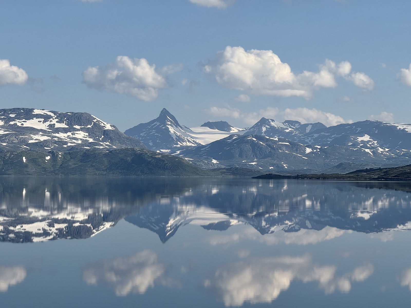
Another day of hot and sunny weather, bringing our streak of (mostly) good weather to nearly 3 weeks! Today was the last of 3 days near Tyin and we'd be travelling back to Lillehammer in the evening (and subsequently the UK, a few days later). We'd climbed Urdanostind 2 days prior but had aborted Falketind yesterday (a large snow bank near the 1291 lake made the route unsafe to pass); we were determined to actually make it up a top today, so opted with an easier looking tour Langeskavltinden. The route had already intrigued us as Langeskavltinden appeared on the map to protrude into a large glacier - its peak nearly surrounded by ice and this ice surrounded by gnarly mountains (including Urdanostind). We had some concern that progress on the 23km route might be slow as it was hard to assess >>>
Uranostind
- Date:
- 16.07.2025
- Characteristic:
- Glacier travel
- Duration:
- 6:00h
- Distance:
- 17.0km
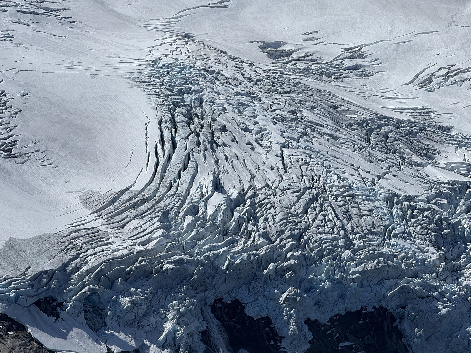
 Coming from the U.K., neither Alice nor I have experience traversing glaciers. Given the two of us want to explore more of Norway, we decided to book a guide across one: so why not use this as an opportunity to climb one of Jotunheimen's most iconic peaks!
We woke near Otrovatnet and took the scenic drive along Tyin towards Tyinholmen Høyfjellsstuer, where we were scheduled to meet with our guide. The sky was clear, wind was light and Uranostind was glimmering, mirrored on the lake.
We met our guide, acquired our helmet, harness and ice axe and were introduced to a lovely Norwegian couple with whom we'd be sharing this tour. Alice gauged that they looked fit and active- a relief as we worried about how slow-going it could be in a guided group. Returning to our car, the guide escorted us down >>>
Coming from the U.K., neither Alice nor I have experience traversing glaciers. Given the two of us want to explore more of Norway, we decided to book a guide across one: so why not use this as an opportunity to climb one of Jotunheimen's most iconic peaks!
We woke near Otrovatnet and took the scenic drive along Tyin towards Tyinholmen Høyfjellsstuer, where we were scheduled to meet with our guide. The sky was clear, wind was light and Uranostind was glimmering, mirrored on the lake.
We met our guide, acquired our helmet, harness and ice axe and were introduced to a lovely Norwegian couple with whom we'd be sharing this tour. Alice gauged that they looked fit and active- a relief as we worried about how slow-going it could be in a guided group. Returning to our car, the guide escorted us down >>>
Kattanakken
- Date:
- 13.07.2025
- Characteristic:
- Hillwalk
- Duration:
- 6:00h
- Distance:
- 15.0km
 Since we first visited the region last September, Alice and I have felt a sense of awe around the Jostedalsbreen glacier. Back then we had hiked to Flatbrehytta and had looked down upon the cascading Flatbreen glacier, where we had spent at least two hours admiring its frightening beauty; even watching from afar as a large chunk crumbled down the icefall. We'd fancied getting close to Jostedalsbreen again, and bookmarked Kattanakken for our next visit.
We had arrived in Stryn the evening before and were set to enjoy two full days in the area. A heatwave had arrived, bringing daytime highs to the high-twenties in the valley- quite a contrast to where we were heading. Setting off from the huge carpark in Briksdalen, we skirted around the many tourists taking the short walk/buggy ride(!?) up to >>>
Since we first visited the region last September, Alice and I have felt a sense of awe around the Jostedalsbreen glacier. Back then we had hiked to Flatbrehytta and had looked down upon the cascading Flatbreen glacier, where we had spent at least two hours admiring its frightening beauty; even watching from afar as a large chunk crumbled down the icefall. We'd fancied getting close to Jostedalsbreen again, and bookmarked Kattanakken for our next visit.
We had arrived in Stryn the evening before and were set to enjoy two full days in the area. A heatwave had arrived, bringing daytime highs to the high-twenties in the valley- quite a contrast to where we were heading. Setting off from the huge carpark in Briksdalen, we skirted around the many tourists taking the short walk/buggy ride(!?) up to >>>

