Archive - Date
Archive - Activity
-
Bike trip (110)
- Bike trip - mixed (25)
- Bike trip - road (85)
-
Drive (9)
- Car drive (9)
-
Other trip (3)
- Kayaking (3)
-
Ski trip (116)
- Backcountry skiing (69)
- Cross-country skiing (47)
- Trip by foot (1884)
Collected lists
-
Utvalgte topper og turmål i Bergen
(348/349)
 99%
99% -
Alle topper i Bergen
(391/398)
98%
-
Voss ≥ 100m pf.
(96/98)
97%
-
Opptur Hordaland
(144/159)
90%
-
Stasjoner på Bergensbanen
(33/40)
82%
-
Ulvik ≥ 100m pf.
(28/38)
73%
-
Hordaland ≥ 100m pf.
(622/863)
72%
-
Mjølfjell PF > 100m
(21/31)
67%
-
Jondal ≥ 100m pf.
(15/23)
65%
-
Dagsturhyttene i Vestland
(36/61)
59%
-
Sunnhordland PF >= 100m
(105/186)
56%
-
Hordaland: Hardanger PF>=100m
(194/359)
54%
-
DNT-hytter i Hordaland
(23/45)
51%
-
Kvinnherad ≥ 100m pf.
(40/79)
50%
-
Eidfjord ≥ 100m pf.
(13/42)
30%
-
Sogndal ≥ 100m pf.
(23/81)
28%
-
Gulen ≥ 100m pf.
(15/54)
27%
-
Vik i Sogn ≥ 100m pf.
(10/46)
21%
-
Sogn - Sør for Sognefjorden PF>=100m
(31/159)
19%
-
DNT-hytter i Sogn og Fjordane
(8/47)
17%

Randifjellet, Vorlandstua and Tveitafjellet
- Date:
- 20.01.2018
- Characteristic:
- Hillwalk
- Duration:
- 4:27h
- Distance:
- 11.2km
 Randifjellet
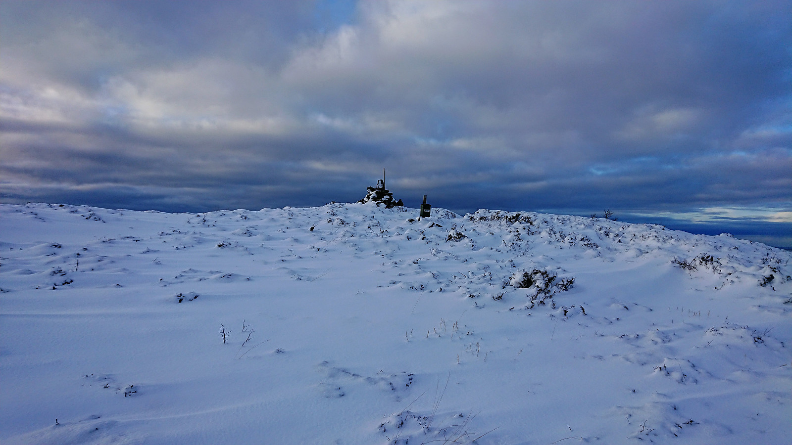
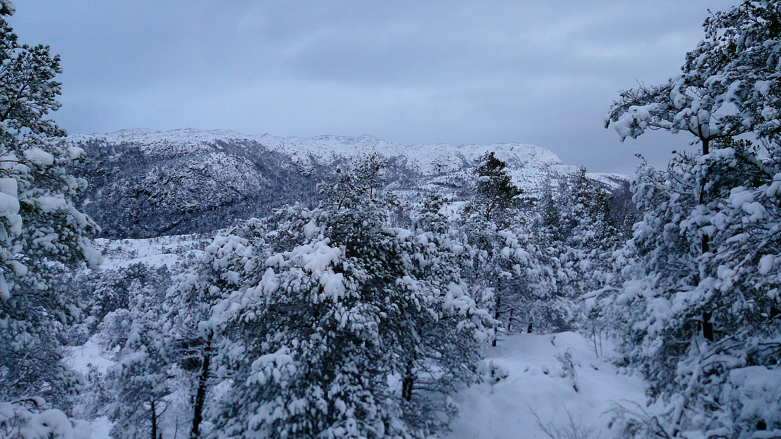
Started by taking the bus to Førde (bus stop Førdespollen) and walked up the paved road to the marked trailhead for Førdesveten . I followed the trail towards Førdesveten and started getting a bit worried about the amount of snow. I was not the first using the trail towards Førdesveten though, so this part was straightforward. However, upon reaching the crossroads with the sign for Randifjellet this would all change.
Apparently, nobody else had thought it a good idea to go to Randifjellet after the recent snow fall, and the trail was therefore not visible at all! I decided to give it a go anyway. However it quickly became clear that this was perhaps a bigger challenge than I had thought, and I was soon struggling with snow up to my knees (and sometimes even higher). Of the trail there was no trace, >>>
Randifjellet
Started by taking the bus to Førde (bus stop Førdespollen) and walked up the paved road to the marked trailhead for Førdesveten . I followed the trail towards Førdesveten and started getting a bit worried about the amount of snow. I was not the first using the trail towards Førdesveten though, so this part was straightforward. However, upon reaching the crossroads with the sign for Randifjellet this would all change.
Apparently, nobody else had thought it a good idea to go to Randifjellet after the recent snow fall, and the trail was therefore not visible at all! I decided to give it a go anyway. However it quickly became clear that this was perhaps a bigger challenge than I had thought, and I was soon struggling with snow up to my knees (and sometimes even higher). Of the trail there was no trace, >>>
Ørneberget in the snow with headlamp
- Date:
- 17.01.2018
- Characteristic:
- Hillwalk
- Duration:
- 1:44h
- Distance:
- 6.6km
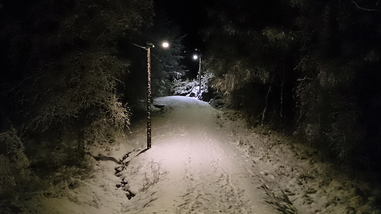 Short local hike across Ørneberget in the snow with headlamp.
Radøy: From Kolås to Rimmo
- Date:
- 13.01.2018
- Characteristic:
- Hillwalk
- Duration:
- 6:16h
- Distance:
- 21.8km
 Morkefjellet
Started by taking the bus to Namntveit (bus stop called Kolås) and from there walking west along the road for a couple hundred meters before leaving the road and heading northeast. This trail was unmarked, but clearly visible from the main road. There was however an information sign stating that I could follow this trail north along the lake all the way to Li.
I followed the trail until locating the sign for Morkefjellet , assuming it would be easy progress towards the summit from here on. However, the trail soon disappeared, and I had to find my own way for a while. I did reconnect with the trail (or perhaps the sign does not accurately indicate where the trail starts?), but the trail was overall very weak until around 150 meters above sea level, were it crossed a fence and then followed a >>>
Morkefjellet
Started by taking the bus to Namntveit (bus stop called Kolås) and from there walking west along the road for a couple hundred meters before leaving the road and heading northeast. This trail was unmarked, but clearly visible from the main road. There was however an information sign stating that I could follow this trail north along the lake all the way to Li.
I followed the trail until locating the sign for Morkefjellet , assuming it would be easy progress towards the summit from here on. However, the trail soon disappeared, and I had to find my own way for a while. I did reconnect with the trail (or perhaps the sign does not accurately indicate where the trail starts?), but the trail was overall very weak until around 150 meters above sea level, were it crossed a fence and then followed a >>>
Langaheia: from Spelhaugen to Nipedalen
- Date:
- 12.01.2018
- Characteristic:
- Hillwalk
- Duration:
- 1:13h
- Distance:
- 3.8km
 Started by taking the bus to Fyllingsdalsveien (bus stop called Skarphaugen) and from there walked up to Spelhaugen and the start of the gravel road towards Tennebekkstjernet.
Immediately after leaving the car park I turned west, crossing the small wooden bridge and followed the unmarked trail to Langaheia . Normally this would be a very easy summit to get to, but today the trail was full of ice and slippery wet roots.
The summit provided much better views than expected. After returning to the gravel road, the plan was to move quickly to the bus stop in Nipedalen. This ended up taking a bit longer than planned though, as significant sections of the road were packed with ice, requiring extra caution. This did however improve when getting closer to Tennebekkstjernet.
From Nipedalen, I took the bus back to >>>
Started by taking the bus to Fyllingsdalsveien (bus stop called Skarphaugen) and from there walked up to Spelhaugen and the start of the gravel road towards Tennebekkstjernet.
Immediately after leaving the car park I turned west, crossing the small wooden bridge and followed the unmarked trail to Langaheia . Normally this would be a very easy summit to get to, but today the trail was full of ice and slippery wet roots.
The summit provided much better views than expected. After returning to the gravel road, the plan was to move quickly to the bus stop in Nipedalen. This ended up taking a bit longer than planned though, as significant sections of the road were packed with ice, requiring extra caution. This did however improve when getting closer to Tennebekkstjernet.
From Nipedalen, I took the bus back to >>>
Tellnes skule to Døsjeskiftet
- Date:
- 06.01.2018
- Characteristic:
- Hillwalk
- Duration:
- 5:15h
- Distance:
- 16.9km
 Started by taking the bus to Tellnes skule. From the bus stop I located the weak trail from the map, which I proceeded to follow west before later turning south and connecting with Nordsjøløypa. The trail was clearly not the most heavily used, but could be easily followed. I missed the crossroads where the trail towards Høgevarden started, but after a couple of meters I connected with the trail, which I then followed almost to the summit, with a shortcut towards the end.
The views were slightly better than expected, but better versions of very similar views can of course be obtained from Liatårnet and Haganesfjellet . After a short stay, I started my descent, this time following the trail all the way to where it connected with Nordsjøløypa. I did not follow the trail all the way back to the bus stop though, but rather followed >>>
Started by taking the bus to Tellnes skule. From the bus stop I located the weak trail from the map, which I proceeded to follow west before later turning south and connecting with Nordsjøløypa. The trail was clearly not the most heavily used, but could be easily followed. I missed the crossroads where the trail towards Høgevarden started, but after a couple of meters I connected with the trail, which I then followed almost to the summit, with a shortcut towards the end.
The views were slightly better than expected, but better versions of very similar views can of course be obtained from Liatårnet and Haganesfjellet . After a short stay, I started my descent, this time following the trail all the way to where it connected with Nordsjøløypa. I did not follow the trail all the way back to the bus stop though, but rather followed >>>
Kolafjellet from Døsjeskiftet
- Date:
- 30.12.2017
- Characteristic:
- Hillwalk
- Duration:
- 3:35h
- Distance:
- 13.3km
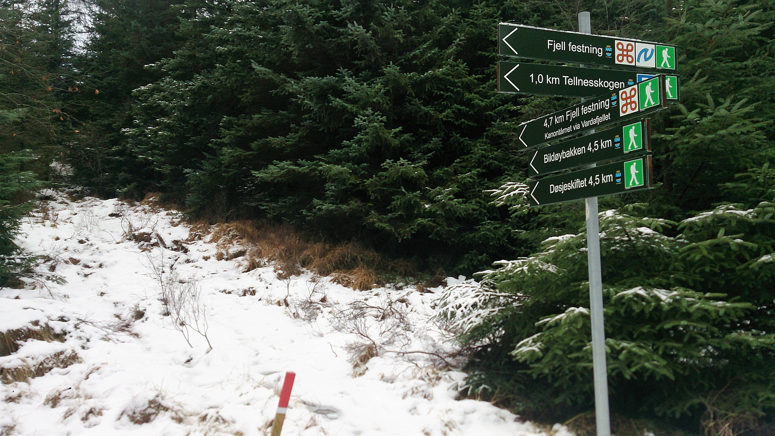 Kolafjellet seemed to be one of those small peaks that are not really worth a hike in itself, so I decided to extend the hike a bit to make the overall trip more enjoyable. Started by taking the bus to Døsjeskiftet and following the paved road up to Bildøyvatnet. From there I followed the marked trail across Vardafjell , ending up at Fjell festning. (The wooden trail markers came in very handy as the trail itself was covered with snow. I therefore more or less ended up walking from one marker to the next.)
I continued south along the roads at Fjell festning until reaching the main road. Previous PB trip reports indicated that there was a tractor road further south that could be utilized to make easy progress towards Kolafjellet. I therefore started walking south along the main road in search of this tractor road, >>>
Kolafjellet seemed to be one of those small peaks that are not really worth a hike in itself, so I decided to extend the hike a bit to make the overall trip more enjoyable. Started by taking the bus to Døsjeskiftet and following the paved road up to Bildøyvatnet. From there I followed the marked trail across Vardafjell , ending up at Fjell festning. (The wooden trail markers came in very handy as the trail itself was covered with snow. I therefore more or less ended up walking from one marker to the next.)
I continued south along the roads at Fjell festning until reaching the main road. Previous PB trip reports indicated that there was a tractor road further south that could be utilized to make easy progress towards Kolafjellet. I therefore started walking south along the main road in search of this tractor road, >>>
Oksneskletten - the extended version
- Date:
- 28.12.2017
- Characteristic:
- Hillwalk
- Duration:
- 3:22h
- Distance:
- 8.9km
 After reading the previous trip reports for Oksneskletten on PB, I concluded that a hike to just the summit would most likely not be the most enjoyable trip (especially given the relatively long travel distance from the Bergen city center). I therefore decided to extend the hike with parts of the Askøy på langs trail to hopefully add some more enjoyable sections.
I therefore started by taking the bus to Merkesvik and from there following the Askøy på langs trail in the southern direction. The marked trailhead was easy to locate from the main road and the trail made it straightforward to progress towards Oksneset.
However, I knew that I had to leave the marked trail to get to the summit of Oksneskletten , but this was easier said than done, as the terrain mainly consisted of trees with thick branches blocking the way or slippery/icy areas with drops >>>
After reading the previous trip reports for Oksneskletten on PB, I concluded that a hike to just the summit would most likely not be the most enjoyable trip (especially given the relatively long travel distance from the Bergen city center). I therefore decided to extend the hike with parts of the Askøy på langs trail to hopefully add some more enjoyable sections.
I therefore started by taking the bus to Merkesvik and from there following the Askøy på langs trail in the southern direction. The marked trailhead was easy to locate from the main road and the trail made it straightforward to progress towards Oksneset.
However, I knew that I had to leave the marked trail to get to the summit of Oksneskletten , but this was easier said than done, as the terrain mainly consisted of trees with thick branches blocking the way or slippery/icy areas with drops >>>
Storevardhaugane, Kjerrgardsåsen and Ospåsen
- Date:
- 21.12.2017
- Characteristic:
- Hillwalk
- Duration:
- 3:07h
- Distance:
- 9.4km
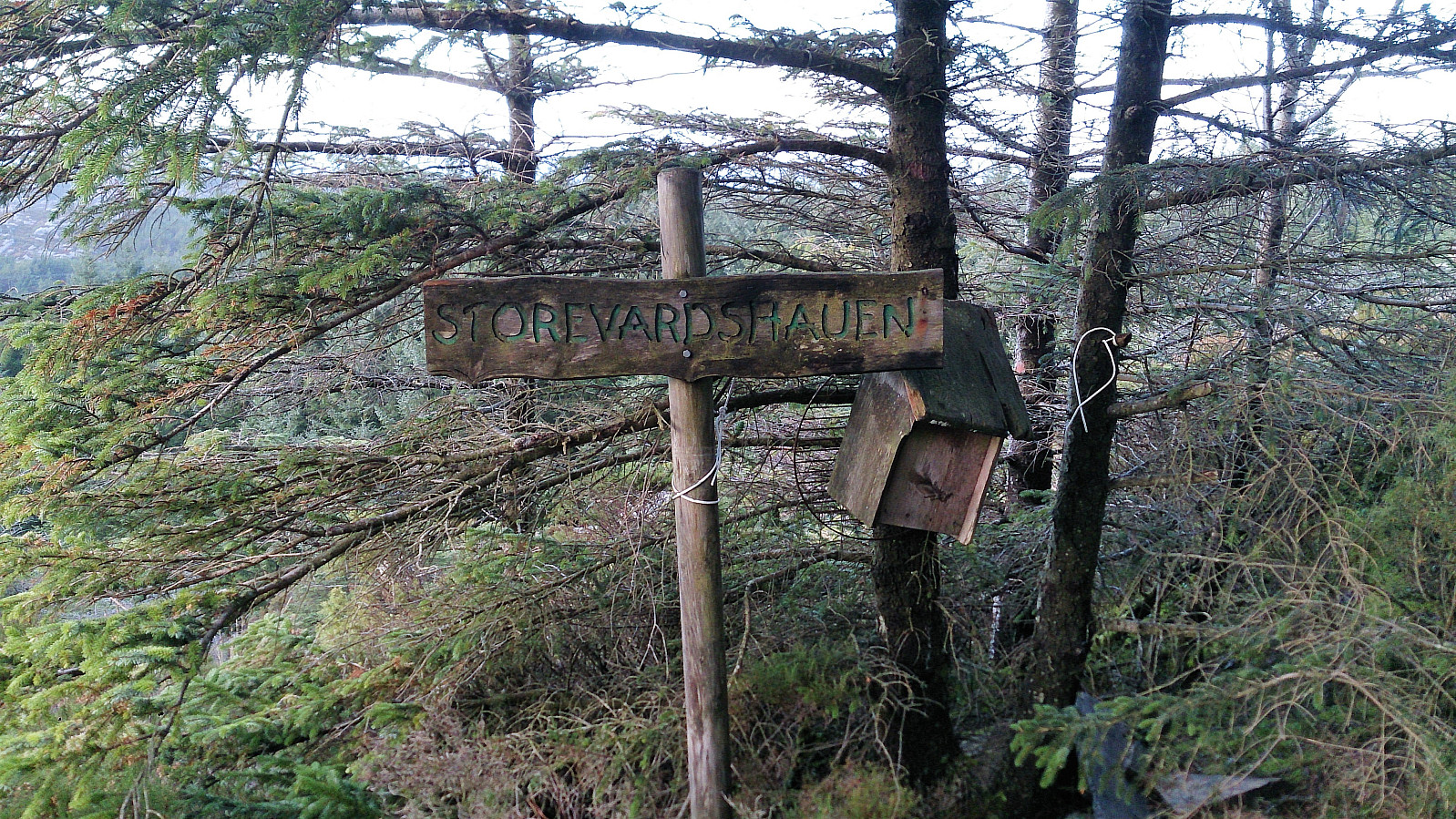 Storevardhaugane
Started by taking the bus to Fromreidetoppen and continued west along the road (~400 m) until reaching the trailhead. There was no sidewalk, but there was a narrow trail on the right-hand side of the road could be used. I tried to follow the trail through the woods towards Storevardhaugane . But this was easier said than done, as there were multiple trails to choose from, all with different (mainly) unlabeled markers, i.e. the GPS came in handy.
Storevardhaugane provided decent views, partly blocked by trees. The view towards Eldsfjellet was particularly nice. After signing the visitor register, and looking for a potentially better view south of the summit (which was not to be found), I retraced my steps to one of the previous crossroads, and headed towards Leirdalen and Berlandsvegen.
Kjerrgardsåsen
I followed >>>
Storevardhaugane
Started by taking the bus to Fromreidetoppen and continued west along the road (~400 m) until reaching the trailhead. There was no sidewalk, but there was a narrow trail on the right-hand side of the road could be used. I tried to follow the trail through the woods towards Storevardhaugane . But this was easier said than done, as there were multiple trails to choose from, all with different (mainly) unlabeled markers, i.e. the GPS came in handy.
Storevardhaugane provided decent views, partly blocked by trees. The view towards Eldsfjellet was particularly nice. After signing the visitor register, and looking for a potentially better view south of the summit (which was not to be found), I retraced my steps to one of the previous crossroads, and headed towards Leirdalen and Berlandsvegen.
Kjerrgardsåsen
I followed >>>
Fjellhytten, Brushytten and Ankerhytten
- Date:
- 16.12.2017
- Characteristic:
- Hillwalk
- Duration:
- 3:33h
- Distance:
- 14.1km
 Started walking from the bus stop at Torget and followed Tippetue up to Fløyen. From there I continued to Fjellhytten before going via Brushytten on the way up towards Rundemanen , and then passing by Ankerhytten on the way down to Munkebotn and finally onwards to Lønborg.
Borgafjellet Roundtrip
- Date:
- 10.12.2017
- Characteristic:
- Hillwalk
- Duration:
- 3:50h
- Distance:
- 13.7km
 Started by taking the bus to Ulvenskiftet and walking up to Tøsdal from where I followed the relatively new gravel road towards Nordmarka/Hjelle, however today the gravel road could not be seen as it was covered by 10-20 centimeters of snow. I made a quick stop at very nice new suspension bridge called Knutabruo , which I of course had to cross, even though my route did not go in that direction. :)
After reaching Hjelle, the trailhead towards Borgafjellet was easily located. Actually, the route to Borgafjellet was marked with signs all the way from Tøsdal. The trail itself was however impossible to see due to all the snow. But as hoped, I was not the only one heading to Borgafjellet this morning, so thankfully there were several of sets of footprints I could follow up the relatively steep incline.
The trail (or >>>
Started by taking the bus to Ulvenskiftet and walking up to Tøsdal from where I followed the relatively new gravel road towards Nordmarka/Hjelle, however today the gravel road could not be seen as it was covered by 10-20 centimeters of snow. I made a quick stop at very nice new suspension bridge called Knutabruo , which I of course had to cross, even though my route did not go in that direction. :)
After reaching Hjelle, the trailhead towards Borgafjellet was easily located. Actually, the route to Borgafjellet was marked with signs all the way from Tøsdal. The trail itself was however impossible to see due to all the snow. But as hoped, I was not the only one heading to Borgafjellet this morning, so thankfully there were several of sets of footprints I could follow up the relatively steep incline.
The trail (or >>>
