Archive - Date
Archive - Activity
-
Bike trip (110)
- Bike trip - mixed (25)
- Bike trip - road (85)
-
Drive (9)
- Car drive (9)
-
Other trip (3)
- Kayaking (3)
-
Ski trip (116)
- Backcountry skiing (69)
- Cross-country skiing (47)
- Trip by foot (1884)
Collected lists
-
Utvalgte topper og turmål i Bergen
(348/349)
 99%
99% -
Alle topper i Bergen
(391/398)
98%
-
Voss ≥ 100m pf.
(96/98)
97%
-
Opptur Hordaland
(144/159)
90%
-
Stasjoner på Bergensbanen
(33/40)
82%
-
Ulvik ≥ 100m pf.
(28/38)
73%
-
Hordaland ≥ 100m pf.
(622/863)
72%
-
Mjølfjell PF > 100m
(21/31)
67%
-
Jondal ≥ 100m pf.
(15/23)
65%
-
Dagsturhyttene i Vestland
(36/61)
59%
-
Sunnhordland PF >= 100m
(105/186)
56%
-
Hordaland: Hardanger PF>=100m
(194/359)
54%
-
DNT-hytter i Hordaland
(23/45)
51%
-
Kvinnherad ≥ 100m pf.
(40/79)
50%
-
Eidfjord ≥ 100m pf.
(13/42)
30%
-
Sogndal ≥ 100m pf.
(23/81)
28%
-
Gulen ≥ 100m pf.
(15/54)
27%
-
Vik i Sogn ≥ 100m pf.
(10/46)
21%
-
Sogn - Sør for Sognefjorden PF>=100m
(31/159)
19%
-
DNT-hytter i Sogn og Fjordane
(8/47)
17%

Storhaug from Vigdalstøl
- Date:
- 08.08.2020
- Characteristic:
- Hillwalk
- Duration:
- 1:50h
- Distance:
- 3.9km
 After an extended lunch break at Vigdalstøl we were ready for the second hike of the day, this time with everybody joining and heading for the smaller hill in between Vigdalstøl and Fivlenosi called Storhaug . We initially followed the marked trail from Vigdalstøl via Breidsete towards Fivla and Kilen in Dalsdalen. However as the trail passed around 150 meter northwest of the summit, we had to leave the nice trail and instead make our own way towards the summit through the semi-dense undergrowth.
This did not provide any real challenges though and we soon connected with a weaker trail along the main ridge, which also did not head all the way to the summit. The summit was finally reached after another 10-15 meters off-trail but it sadly provided close to no views and if it had not been for the 115 meter vertical separation >>>
After an extended lunch break at Vigdalstøl we were ready for the second hike of the day, this time with everybody joining and heading for the smaller hill in between Vigdalstøl and Fivlenosi called Storhaug . We initially followed the marked trail from Vigdalstøl via Breidsete towards Fivla and Kilen in Dalsdalen. However as the trail passed around 150 meter northwest of the summit, we had to leave the nice trail and instead make our own way towards the summit through the semi-dense undergrowth.
This did not provide any real challenges though and we soon connected with a weaker trail along the main ridge, which also did not head all the way to the summit. The summit was finally reached after another 10-15 meters off-trail but it sadly provided close to no views and if it had not been for the 115 meter vertical separation >>>
Kattøyro from Vigdalstøl
- Date:
- 08.08.2020
- Characteristic:
- Hillwalk
- Duration:
- 3:34h
- Distance:
- 9.3km
 After spending the night at Vigdalstøl , me and my sister first followed the marked trail to Drivande , from where we followed a weaker trail marked with small cairns towards Kattøyro .
At first the trail was relatively easy to follow, the trailhead was even marked with a sign, but later it pretty much disappeared and we had to find our own way towards the summit. The terrain did not present any real challenges though and the large cairn with a visitor register was easily reached.
Excellent views from the summit, although the views were a bit limited by the gray weather, especially in the direction of Hurrungane . For the descent we followed more or less the same route, the only difference being that the nice weather we had enjoyed for most of the ascent soon was replaced by rain and low-hanging clouds.
Overall a very nice hike that >>>
After spending the night at Vigdalstøl , me and my sister first followed the marked trail to Drivande , from where we followed a weaker trail marked with small cairns towards Kattøyro .
At first the trail was relatively easy to follow, the trailhead was even marked with a sign, but later it pretty much disappeared and we had to find our own way towards the summit. The terrain did not present any real challenges though and the large cairn with a visitor register was easily reached.
Excellent views from the summit, although the views were a bit limited by the gray weather, especially in the direction of Hurrungane . For the descent we followed more or less the same route, the only difference being that the nice weather we had enjoyed for most of the ascent soon was replaced by rain and low-hanging clouds.
Overall a very nice hike that >>>
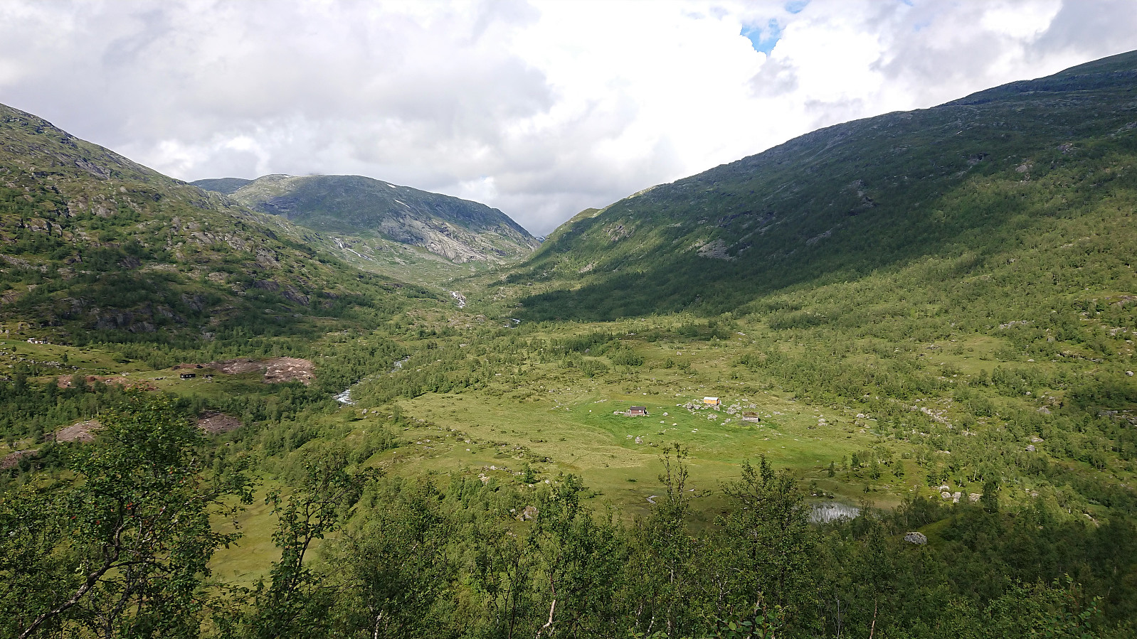
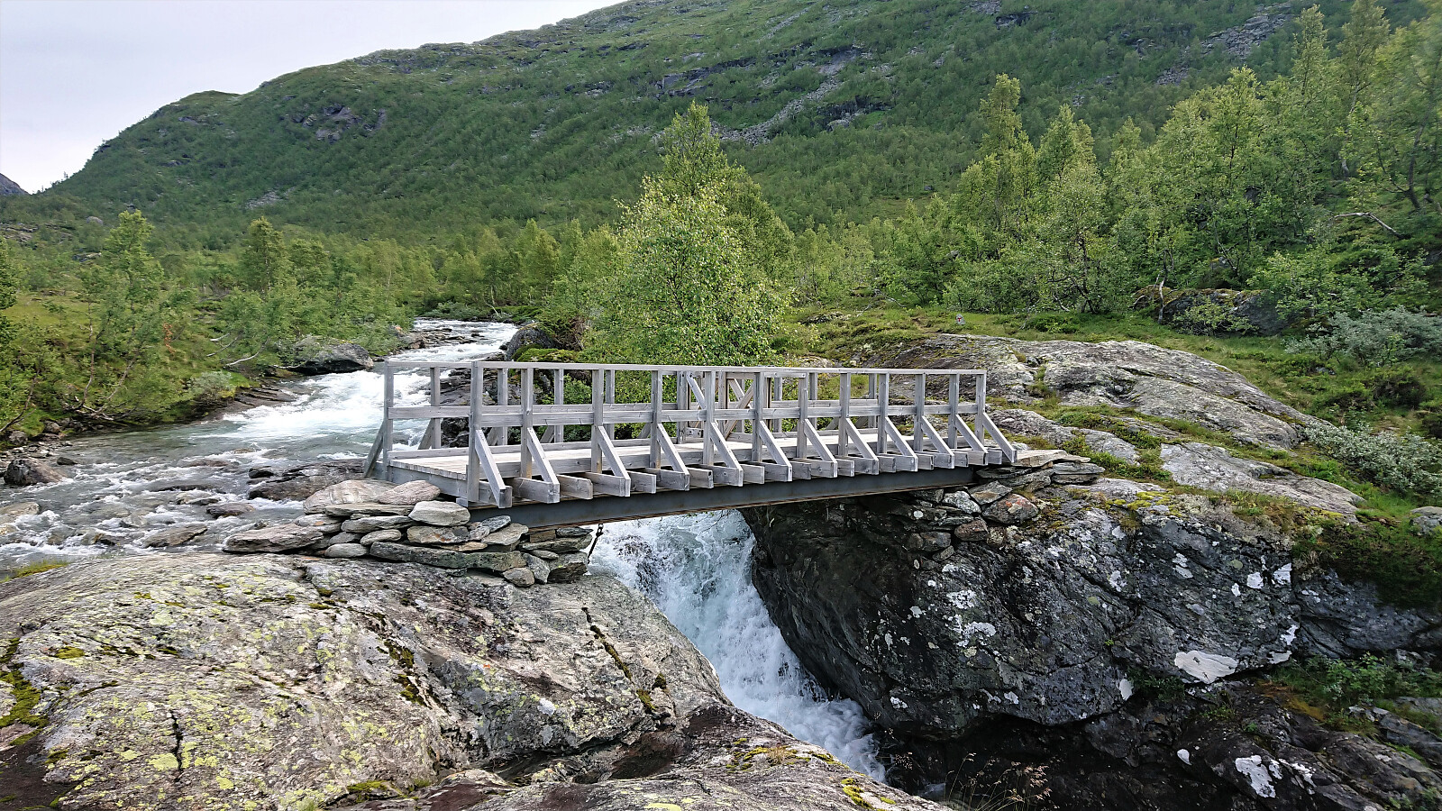
Vigdalstøl
- Date:
- 07.08.2020
- Characteristic:
- Hillwalk
- Duration:
- 0:42h
- Distance:
- 1.7km
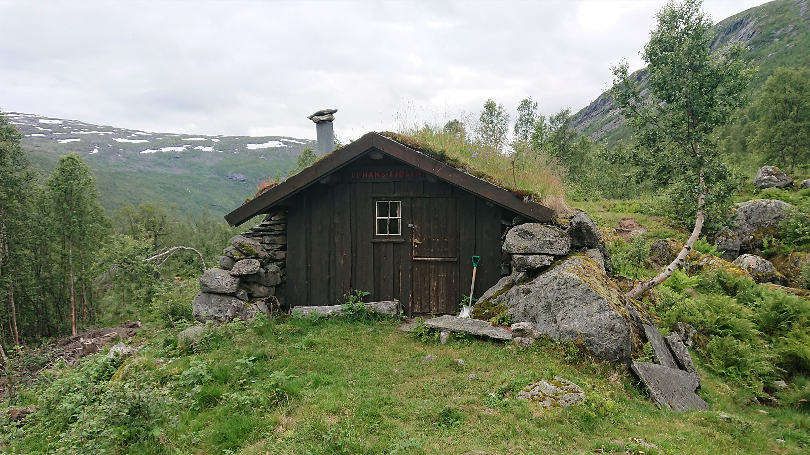 Short hike along the marked trail from the parking lot at Vårstølen to Vigdalstøl to spend the weekend there with my sister and her family, where we also took advantage of the four extra beds in Li-Hans-Fjøsen located less than 20 meters west of the main cabin.
Høgafjellet
- Date:
- 31.07.2020
- Characteristic:
- Hillwalk
- Duration:
- 0:56h
- Distance:
- 2.6km
 After leaving my bike by the side of the road (see the separate cycling trip report ), I started up what was initially a weak tractor road which soon turned into a rather wet trail. The trail quality however greatly improved as the trail started to climb up to the small valley south of the summit. From there the trail was less clear, but it was instead marked by small cairns, and at this point the large cairn at the summit could be spotted anyway and the direction was obvious.
The summit provided excellent views in all directions and was today occupied by several families with lots of kids. I still managed to get a couple of nice pictures before having a second short lunch break and then returning along the same route to the main road. However, if I did not have to return to my bike, I would probably instead have tried >>>
After leaving my bike by the side of the road (see the separate cycling trip report ), I started up what was initially a weak tractor road which soon turned into a rather wet trail. The trail quality however greatly improved as the trail started to climb up to the small valley south of the summit. From there the trail was less clear, but it was instead marked by small cairns, and at this point the large cairn at the summit could be spotted anyway and the direction was obvious.
The summit provided excellent views in all directions and was today occupied by several families with lots of kids. I still managed to get a couple of nice pictures before having a second short lunch break and then returning along the same route to the main road. However, if I did not have to return to my bike, I would probably instead have tried >>>
Skjønhammaren
- Date:
- 31.07.2020
- Characteristic:
- Hillwalk
- Duration:
- 0:34h
- Distance:
- 0.9km
 After finally deciding to leave my bike at the crossroads about 200 meters southwest of the summit, I continued on foot along a very wet trail, made slightly less wet by several wide wooden planks, some of them half submerged in water. The trail quality however greatly improved as the trail turned north for the summit. Here there was even a sign for Skjønhammaren . (A hidden sign at the earlier crossroads had only shown "Natursti", i.e. nature trail.)
The summit (at 112.66 meters above sea level as the sign at the summit indicated) was quickly reached and provided excellent views to the south, while the views to the north were blocked by trees.
After a short lunch break, I briefly followed the trail north, from where I could spot Kattnakken in the distance, although the northern views were still pretty limited from here >>>
After finally deciding to leave my bike at the crossroads about 200 meters southwest of the summit, I continued on foot along a very wet trail, made slightly less wet by several wide wooden planks, some of them half submerged in water. The trail quality however greatly improved as the trail turned north for the summit. Here there was even a sign for Skjønhammaren . (A hidden sign at the earlier crossroads had only shown "Natursti", i.e. nature trail.)
The summit (at 112.66 meters above sea level as the sign at the summit indicated) was quickly reached and provided excellent views to the south, while the views to the north were blocked by trees.
After a short lunch break, I briefly followed the trail north, from where I could spot Kattnakken in the distance, although the northern views were still pretty limited from here >>>
Flot and Barsnesfjorden
- Date:
- 28.07.2020
- Characteristic:
- Hillwalk
- Duration:
- 1:47h
- Distance:
- 6.2km
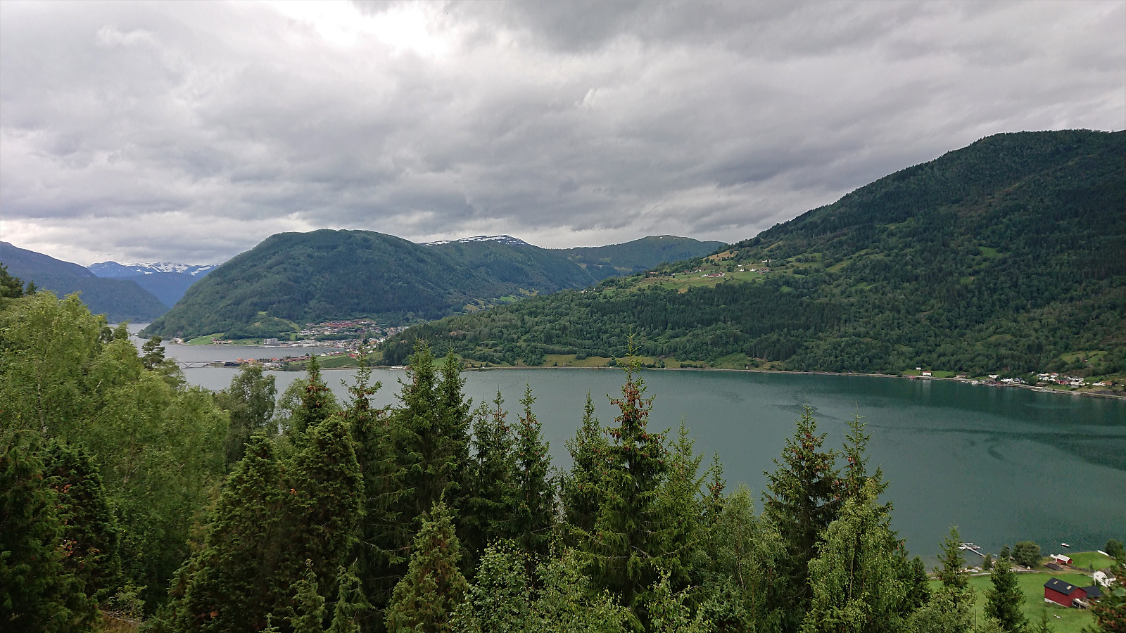 A repeat of the hike across Flot. This time with Sigjoern (Sigbjørn Holm) and Marthine, and also including a walk along Barsnesfjorden.
(Note that the road this hike follows is private, i.e. no cars allowed. There are however a couple of parking spaces down by the small wharf along Barsnesfjorden just before the road turns west and starts climbing slightly towards the crossroads at Barsnes.)
A repeat of the hike across Flot. This time with Sigjoern (Sigbjørn Holm) and Marthine, and also including a walk along Barsnesfjorden.
(Note that the road this hike follows is private, i.e. no cars allowed. There are however a couple of parking spaces down by the small wharf along Barsnesfjorden just before the road turns west and starts climbing slightly towards the crossroads at Barsnes.)
Flot
- Date:
- 26.07.2020
- Characteristic:
- Hillwalk
- Duration:
- 2:25h
- Distance:
- 3.5km
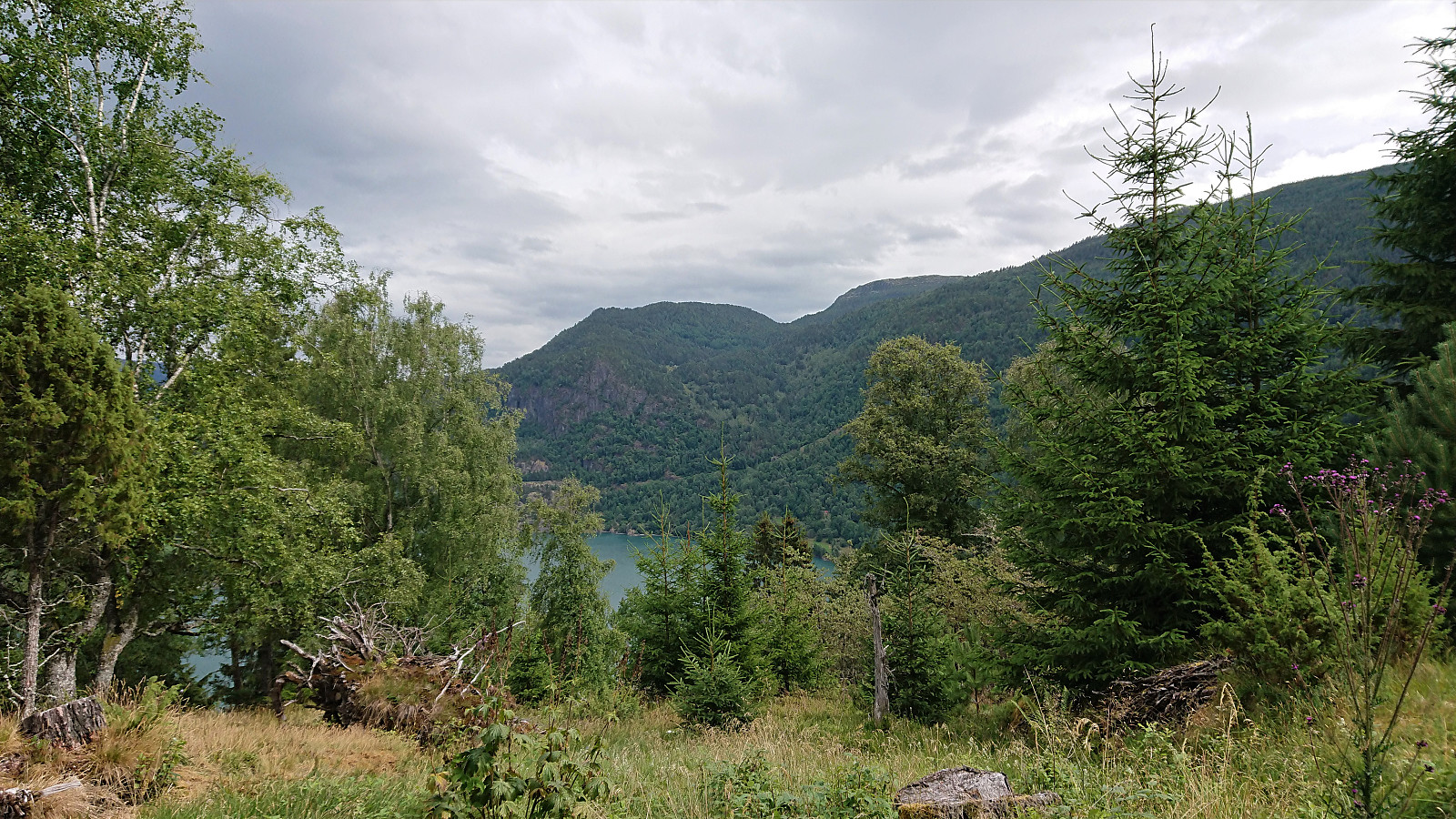 The standard walk across Flot with family members including kids, hence the numerous breaks and slow speed. :)
(Note that the road this hike follows is private, i.e. no cars allowed. There are however a couple of parking spaces down by the small wharf along Barsnesfjorden just before the road turns west and starts climbing slightly towards the crossroads at Barsnes.)
The standard walk across Flot with family members including kids, hence the numerous breaks and slow speed. :)
(Note that the road this hike follows is private, i.e. no cars allowed. There are however a couple of parking spaces down by the small wharf along Barsnesfjorden just before the road turns west and starts climbing slightly towards the crossroads at Barsnes.)
Stav from Hella
- Date:
- 24.07.2020
- Characteristic:
- Hillwalk
- Duration:
- 8:20h
- Distance:
- 24.7km
 On what would turn out to be a perfect day for hiking, me and my niece started the day by taking the first bus from Sogndal to Hella, where we planned to get off at the stopped called "Hella indre". But for some reason the bus driver did not stop (even though we pressed the stop button), and we therefore had to walk the 800 meters back from the Hella. Here we easily located the marked trailhead for Vassvarden and proceeded to follow the nice winding trail up towards Vestrheim.
At Vestrheim we came across the old school building and a sign pointing left (i.e. west) for Ruud (or Rud as it was called on the map), our next target. However, this trail quickly started descending and seemed to be heading in the wrong direction. We therefore shortly returned to the old school where we found another >>>
On what would turn out to be a perfect day for hiking, me and my niece started the day by taking the first bus from Sogndal to Hella, where we planned to get off at the stopped called "Hella indre". But for some reason the bus driver did not stop (even though we pressed the stop button), and we therefore had to walk the 800 meters back from the Hella. Here we easily located the marked trailhead for Vassvarden and proceeded to follow the nice winding trail up towards Vestrheim.
At Vestrheim we came across the old school building and a sign pointing left (i.e. west) for Ruud (or Rud as it was called on the map), our next target. However, this trail quickly started descending and seemed to be heading in the wrong direction. We therefore shortly returned to the old school where we found another >>>
Ovriseggi
- Date:
- 22.07.2020
- Characteristic:
- Hillwalk
- Duration:
- 0:59h
- Distance:
- 3.7km
 On the way from Bergen to Sogndal we stopped at the start of the descent to Vik for a quick visit of Ovriseggi . Note that the right-hand turn into Ovridseggi parkering is partially hidden when coming from the south and requires a steep turn. From the parking lot we followed the marked trail north along the ridge, with excellent views into Ovrisdalen. The trail had some wet areas, but was otherwise straightforward to follow.
Just before reaching the summit of Ovriseggi, we had to descend relatively steeply into a small valley before making the final ascent to the highest point. This potentially slippery section can however easily be avoided by following the alternative trail to the west (see the return route). The summit provided excellent views down into Bøadalen, although Vik itself was partially hidden by Daurmålshaugen . The trail >>>
On the way from Bergen to Sogndal we stopped at the start of the descent to Vik for a quick visit of Ovriseggi . Note that the right-hand turn into Ovridseggi parkering is partially hidden when coming from the south and requires a steep turn. From the parking lot we followed the marked trail north along the ridge, with excellent views into Ovrisdalen. The trail had some wet areas, but was otherwise straightforward to follow.
Just before reaching the summit of Ovriseggi, we had to descend relatively steeply into a small valley before making the final ascent to the highest point. This potentially slippery section can however easily be avoided by following the alternative trail to the west (see the return route). The summit provided excellent views down into Bøadalen, although Vik itself was partially hidden by Daurmålshaugen . The trail >>>
Bergen: Jubileumsstien (Stage 7 and 8)
- Date:
- 18.07.2020
- Characteristic:
- Hillwalk
- Duration:
- 2:58h
- Distance:
- 12.0km
 Jubileumsstien
 is a new trail (or mainly a combination of existing trails) that makes it possible to hike across Bergen, from Krokeide in the south to Tellevik in the north, a total distance of about 55 km. This hike includes Stage 7 and 8, the two final stages, from Myrdalsvegen to Tellevik kai. See my reports for the previous stages here: Stage 1 and 2 , Stage 3 and 4 , and Stage 5 and 6 .
Stage 7: Myrdalsvegen to Støbotn
From the marked trailhead at Myrdalsvegen the trail winded its way up towards Ulsetvarden , making several odd turns along the way. Thankfully all of them were clearly marked, as the trail itself was rather weak at the start. It also turned relatively muddy before reaching the summit. Ulsetvarden provided nice views back towards Åsane and also northwest in the direction of Toppe.
The trail northwest from Ulsetvarden to the >>>
Jubileumsstien
Jubileumsstien is a new trail (or mainly a combination of existing trails) that makes it possible to hike across Bergen, from Krokeide in the south to Tellevik in the north, a total distance of about 55 km. This hike includes Stage 7 and 8, the two final stages, from Myrdalsvegen to Tellevik kai. See my reports for the previous stages here: Stage 1 and 2 , Stage 3 and 4 , and Stage 5 and 6 .
Stage 7: Myrdalsvegen to Støbotn
From the marked trailhead at Myrdalsvegen the trail winded its way up towards Ulsetvarden , making several odd turns along the way. Thankfully all of them were clearly marked, as the trail itself was rather weak at the start. It also turned relatively muddy before reaching the summit. Ulsetvarden provided nice views back towards Åsane and also northwest in the direction of Toppe.
The trail northwest from Ulsetvarden to the >>>
