Fuglenosi from Gravalen and Hjelle via Avdal gard (30.06.2024)

| Start point | Gravdalen (840m) |
|---|---|
| Endpoint | Hjelle (75m) |
| Characteristic | Hike |
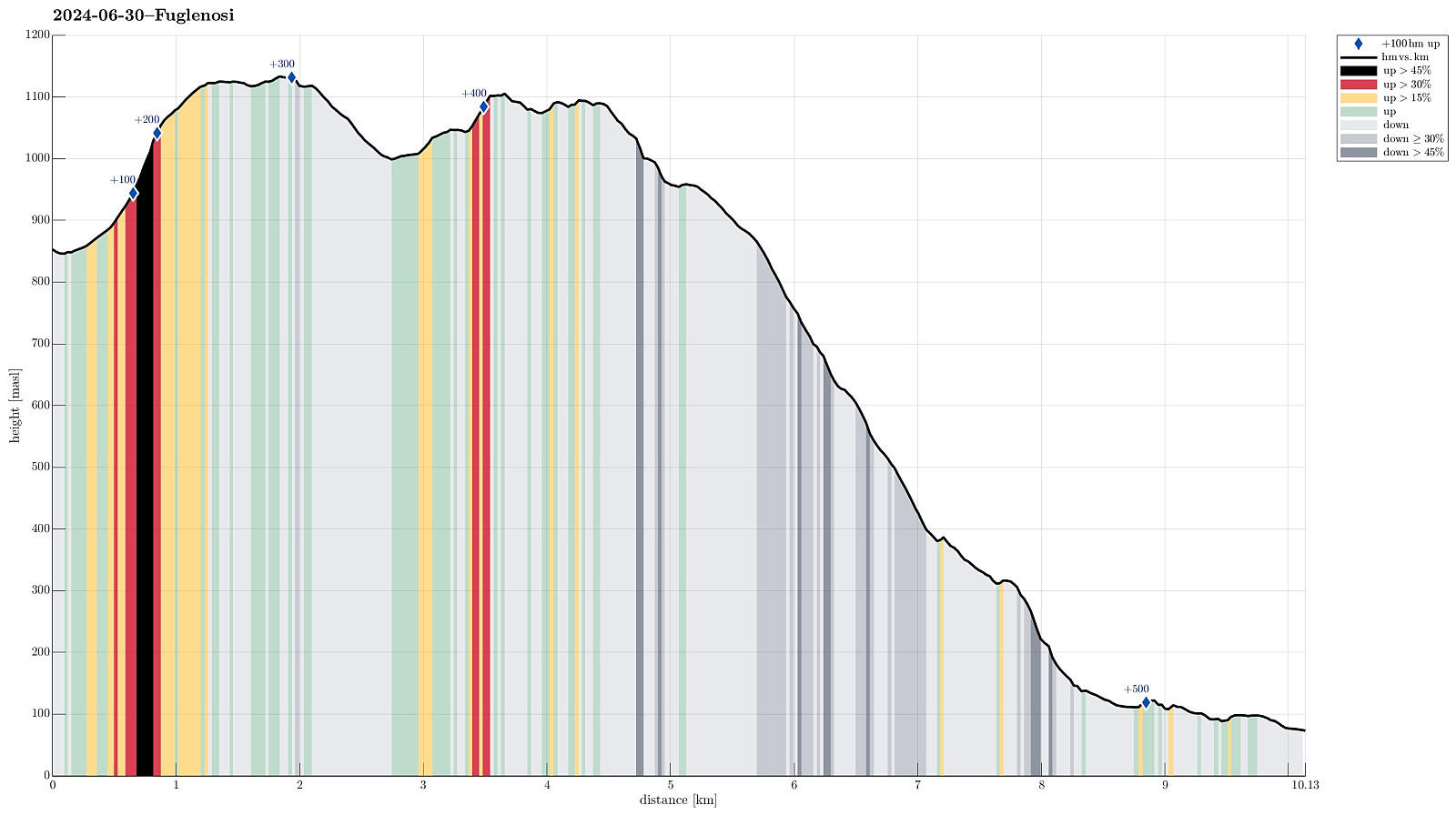
| Duration | 5h 30min |
| Distance | 10.1km |
| Vertical meters | 527m |
| GPS |
|
| Ascents | Fuglenosi (1,096m) | 30.06.2024 |
|---|---|---|
| Visits of other PBEs | Avdalen Gard (380m) | 30.06.2024 |
| Avdalsfossen (180m) | 30.06.2024 | |
| Gravdalen (840m) | 30.06.2024 | |
| Hjelle parkeringsplass (75m) | 30.06.2024 | |
| Hjellefossen (120m) | 30.06.2024 | |
| Utladalen Naturhus (95m) | 30.06.2024 |
Trip Summary
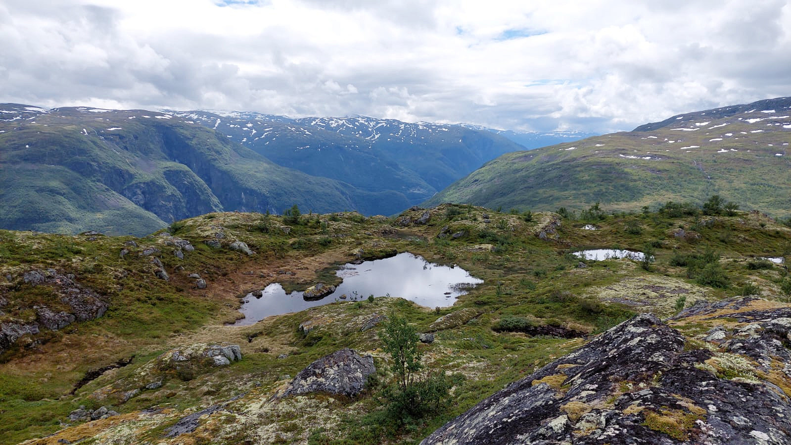
With many days in advance, we originally had thought to hike up to Stølsmaradalstinden from Gravdalen on this day. Given the weather (medium-high clouds, well engulving the highest tops, with some precipitation every now and then) and the rather wet walk through Gravdalen on the day before, we decided to drop our Stølsmaradalstinden plan and instead do something below the clouds. Still recalling the map that had suggested that one could find a trail, crossing over at Åsetvatnet and then continuing further along the heights to Stølsmaradalen, and also having read that the trail between Avdal gard and Stølsmaradalen should be nice and well-marked, we decided to hike first to Fuglenosi and then to find a way down to the trail between Avdal gard and Stølsmaradalen (in order to walk this trail then down to Avdal gard). We thus started from the cabin in Gravdalen, heading to the nearest high-point above the valley (in northern/northeastern direction). Without any trail, this ascent started gently in Gravdalen, then becoming increasingly steep soon. Once up some 100 height meters from the cabins, we occasionally needed to use our hands in addition to climb up some steeper sections. This was a bit of an adventure, but also not really very difficult. Yet plus 100 height meters further up, the terrain became much less steep, again, and making progress was again easy (also without a trail). We then crossed over the heights (further northwards, mostly) until we indeed spotted a small cairn -- what a nice surprise (we had not expected to find any trail after the experience near Åsetvatnet on the day before). Even though the small cairns, which indeed marked this "trail", weren't always easy (or even possible) to see, we still managed to follow the "trail" into Slufsedalen. There, we again met a stream-crossing challenge (even though of smaller dimension, this time). Also Slufsedøla showed itself full of melt-water, powering down the valley. Again, we first explored the stream for some stretch first down along Slufsedøla, and then back up again. Right below a small waterfall, we then found a place, where the stream was a bit wider, which suggested that it would not be all that deep there. This time, we decided to take off our hiking boots, thinking that we needed them for quite some kilometers, still, on this day, and also our trousers, mounting everything firmly to our backbags. Then, with the important help of our hiking sticks, we made it safely also through Slufsedøla! :-) Certainly an interesting experience -- every time! :-) On the other side of Slufsdalen, crossing up and over to Fuglenosi was then nice and easy (we decided to step off-trail since we thought that the trail headed right into a very wet stretch before leading further up, again). At Fuglenosi, we then enjoyed some very nice views (as well as a bit of lunch!). We also got to see something that possibly could be interpreted as a trail (??)... Choosing to try this "trail" (in eastern direction), we hoped that it would help us down to the nice trail between Avdal gard and Stølsmaradalen. This descent was not very long (some 150 heights meters down), but very steep, requiring careful stepping. After making it "all the way down" to about 960 masl, we then found the trail, which indeed proved to be very nice and well-marked! Hiking this trail down to Avdal gard was then straight-forward and nice. At Avdal gard, which indeed is very impressive (see the photos, for example), we then enjoyed a coffee and a waffle -- nice! :-) From Avdal gard, we then took the "standard route" down (not via Avdalsskori) to get some nice views of Avdalsfossen. This way, we got to see this impressive waterfall from above, from mid-heights, and from below. :-) Walking out Utladalen to Hjelle is then easy (but very impressive!). At Hjelle, we then also enjoyed nice views of Hjellefossen! Lucky oss, we then met two hikers, who were so friendly to take us out to Øvre Årdal with their car. Hiking these 6km would have been possible, of course, but clearly this would not have been the nicest part of this hike, even though Utladalen is truly impressive!
Photos
Selected photos are available as Google photo album.
Useful Resources
See also the related FB-page Hiking around Bergen, Norway.
Web page UT.no from the Norwegian Trekking Association recommends a hike from Hjelle to Avdal gard.

User comments