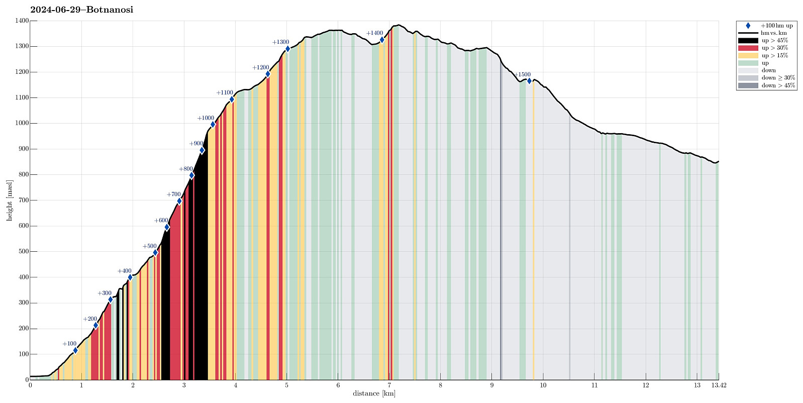
Gravdalen via Botnanosi from Øvre Årdal (29.06.2024)

| Start point | Øvre Årdal (15m) |
|---|---|
| Endpoint | Gravdalen (840m) |
| Characteristic | Hike |
| Duration | 7h 00min |
| Distance | 13.4km |
| Vertical meters | 1,537m |
| GPS |
|
| Ascents | Botnanosi (1,386m) | 29.06.2024 |
|---|---|---|
| Botnanosi sør (1,356m) | 29.06.2024 | |
| Visits of other PBEs | Gravdalen (840m) | 29.06.2024 |
| Ramneberg utsiktspunkt (363m) | 29.06.2024 | |
| Sprekisnosi (998m) | 29.06.2024 |
Trip Summary
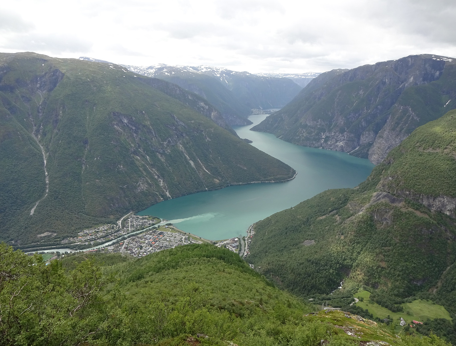
Our original plan was to first go up to Gravdalen and then, on the next day, further up to Stølsmaradalstinden. The weather forecast, however, did not look all too promising until only shortly before we left for Øvre Årdal. On the day before we wanted to start our two-days hike, however, the forecast became better (not really good, though) and so we decided to at least begin with the first planned leg (from Øvre Årdal to Gravdalen via Botnanosi). After finding a suitable place in Øvre Årdal, where we could leave our car for the night, also, we started the hike following a well-marked trail up to Ramnaberget, i.e., the impressive cliff directly north of Øvre Årdal. After enjoying the views from Ramnaberget (and a nice little chat with two hikers from England), we continued along the red-marked trail upwards. This trail leads up the ridge towards Botnanosi (much further up). It is steep, but in very good condition. At about 1000 masl, we came to a nice cairn with label "Sprekisnosi". This was a good place for a short break and for enjoying some breath-taking views over Årdalsvatnet! Since the weather was shifting between fine and wet (and since it was windy and quite cold up on the heights), we did not stay long at Sprekisnosi, but continued soon further upwards into the direction of Botnanosi. At about 1365 masl, we passed by a very nice cairn on a minor top south of Botnanosi. We then headed down to Botnavatnet, also in the south of Botnanosi. Ascending to Botnanosi north of Botnavatnet was then a bit steep, but no problem at all. Since we had read in preparation of this hike that the bridge right next to the cabins at Gravdalen got damaged by the river recently, we needed an alternative plan to get over Gravdøla in Gravdalen: continue first further northwards to Åsetvatnet, then down into Gravdalen and across Gravdøla at about 960 masl (without a bridge, though). On the map, we had seen a nicely marked trail there, which made us think that crossing Gravdøla "on the trail" should be without problems. Traversing over the heights from Botnanosi to Åsetvatnet was then "straight-forward" and also very nice. But finding the trail, which the map had promised, was not possible. Even with a bit of back and forth, no sign of any trail was to be seen. Stepping down into Gravdalen, however, was not a problem at all as large stretches of Gravdalen are gentle (and very wet!) slopes of very low vegetation anyway. The bigger question, then, regarding our necessary crossing of Gravdøla. This stream was well-swollen with loads of melt-water from the glaciers higher up in Hurrungane. We walked a bit up and down along the west-side of Gravdøla, but could not find a spot, which looked "easy". Also, it became very clear that it was impossible to avoid stepping quite deeply (more than knee-deep) into the stream. We had brought some plastic waste-bags that we took around our hiking boots, securing them with gaiters, but clearly these bags were too short! :-) Luckily, we had brought hiking sticks! Without any reasonable alternative, we chose a "best-possible" place to cross the stream and stepped into it. The ice-cold water was one challenge, but more critical was to not lose our balance in the raging waters. Still, we made it safely to the other, eastern side of Gravdøla -- yes, with soaked boots... Walking down Gravdalen to the cabins at about 850 masl was then "straight-forward". Gravdalen is indeed very, very wet with numerous mini-streams coming down "from all sides". At least we did not have to care about all this water, given our already all-wet shoes! :-) Eventually, after a longer day of hiking, we nicely made it to the cabins at Gravdalen. Since none else than us had decided to visit Gravdalen on this day, we could choose, which of the three cabins we liked the best. :-) Firing up the stove, we also hoped that our shoes would dry up at least a little bit before leaving Gravdalen on the next day. :-)
Photos
Selected photos are available as Google photo album.
Useful Resources
See also the related FB-page Hiking around Bergen, Norway.
Web page UT.no from the Norwegian Trekking Association recommends a similar hike up to Botnanosi.

User comments