Breheimen, day 2: from Fast to Arentzbu (25.07.2019)

| Start point | Fast (856m) |
|---|---|
| Endpoint | Arentzbu (880m) |
| Characteristic | Hike |
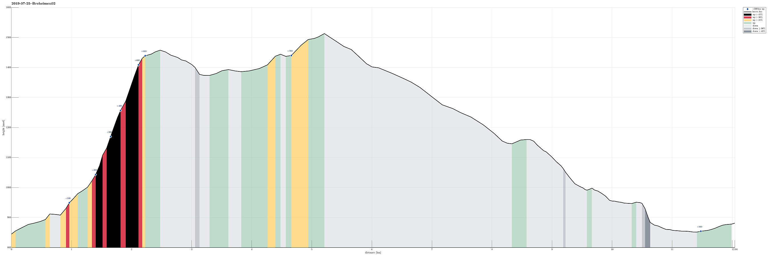
| Duration | 7h 00min |
| Distance | 12.0km |
| Vertical meters | 826m |
| GPS |
|
| Ascents | Høyde nær Spørteggbreen (1,514m) | 25.07.2019 |
|---|---|---|
| Kolinosi (1,459m) | 25.07.2019 | |
| Visits of other PBEs | Arentzbu (880m) | 25.07.2019 |
| Fast (856m) | 25.07.2019 | |
| Kvitene (950m) | 25.07.2019 |
Trip Summary
After day #1 of our five days hike through Breheimen, we continued from Fast with the goal to get to Arentzbu. The default idea was to follow the marked trail: first eastwards along the northern side of Åsetevatnet, then northwards (passing by Skurvenosi on its western side), before eventually continuing to Arentzbu along the southwestern side of Mørkrisdalen.
Kolinosi
Instead, we cooked up an alternative route that would bring us much closer to the big glacier Spørteggbreen. We thus left the cabin at Fast in northwestern direction instead (without any marked or even well-visible trail) and headed into Langgrø, a nice valley with steep mountain sides to the left and right. Rougly 1km into the valley, we came around a gentle ridge, coming down from Soleibotnane. We felt invited to start ascending (more or less directly into the direction of Kolinosi), knowing that we should either head eastwards (towards Soleinotnane), or westwards (deeper into Langgrø to later cross over between Langgrønosi and Kolinosi). Somehow, we missed the right spot to turn (either left or right) and soon found ourselves quite a bit up on the (steep) southern mountain side of Kolinosi. After considering our situation for a bit, we decided to continue and step up to Kolinosi directly from the south. Bearing our heavy backpacks, this ascent was somewhat at the edge of what is easily doable; we did have good steps (over grass etc.) all the time, but you need to be stable all the time in the (very) steep terrain. Eventually, we made it to the top of Kolinosi without any difficulties, but it is recommended to carefully evaluate whether this ascent is indeed the best idea, if one is heading for Kolinosi.
To Arentzbu via Kvitene
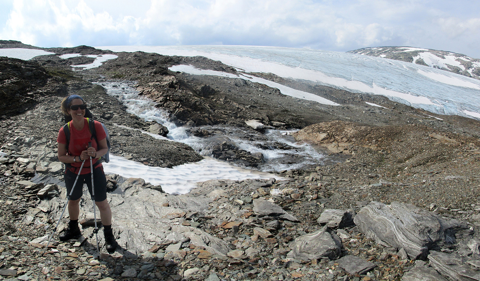
Once we had enjoyed some great views from Kolinosi, we were ready to continue (towards Arentzbu). Our idea was to pass by the big glacier of Spørteggbreen (closely). Also, we were playing with the idea of including Grånosi, but it was unclear, how to do it (first "all the way down" at Kvitene, before then ascending to Grånosi along its eastern ridge; or crossing Spørteggbreen to get to Grånosi along a much shorter line). Descending from Kolinosi in northwestern direction was easy and straight-forward. Soon, however, we spotted our next challenge: Feeding Austratjørnene (to our right), a major glacial river sprang out of Spørteggbreen (to our left), and in order to get furthere towards Arentzbu, we needed to cross this stream somehow (no bridge there, of course). Luckily, we had packed some simple extra "shoes" (two pairs of sandals). Changing our boots for our sandals, and using our walking sticks to keep our balance, we managed to step through the ice-cold glacial waters -- definitely, an experience! :-) On the other side, we then continued to ascend further towards Spørteggbreen, until we stood at a little height (1514mosl) right next to the glacier. And what an impressive view this is?!! Clearly, there was no way to cross the glacier without special safty equipment! Hiking along the southern side of the glacier, we descended into the direction of Mørkrisdalen. A couple of height meters further down, we also understood that crossing over to Grånosi without any brigde "at hand" seemed overly challenging, since loads and loads of melt water was streaming down from the glacier. So we dropped Grånosi and headed for Fjellslitjørni instead, a lovely little lake south of the glacial streams (Kvitene). Refreshing ourselves in the wonderful waters of Fjellslitjørni for a while, we continued further down in order to connect with the marked trail, coming over from Fjellsli (our thought was to cross Kvitene on this trai, hoping for some bridges there!). At about 1000mosl, we found the trail to Arentzbu and followed it northwards. At Kvitene, we did find some bridges (and they were indeed very, very helpful!), but by the time of the day (late afternoon), the amount of melt-waters coming down Kvitene was so much that all the area was flooded (with the bridges standing somewhat out). Accepting that we would finish our hike, this day, in wet shoes, we crossed over Kvitene through the flooded area. From there, it was then no very far to Arentzbu.
End of Day 2
After a lovely hiking day #2, we found our beds in the cabin at Arentzbu, getting ready for day #3 of our five days hike through Breheimen.
Photos
Selected photos are available as Google photo album.
Useful Resources
See also the related FB-page Hiking around Bergen, Norway.
The National Park Breheimen has its own home page.
Web page UT.no from the Norwegian Trekking Association recommends the default route between Arentzbu and Fast.

User comments