Breheimen, day 3: from Arentzbu to Nørdstedalseter (26.07.2019)

| Start point | Arentzbu (880m) |
|---|---|
| Endpoint | Nørdstedalseter (937m) |
| Characteristic | Hike |
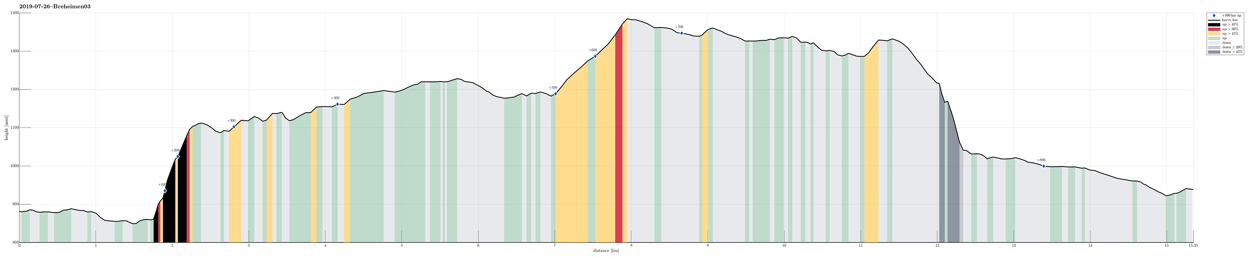
| Duration | 7h 00min |
| Distance | 15.3km |
| Vertical meters | 828m |
| GPS |
|
| Visits of other PBEs | Arentzbu (880m) | 26.07.2019 |
|---|---|---|
| Mørkrisdalen utsikt (1,140m) | 26.07.2019 | |
| Nørdstedalseter (938m) | 26.07.2019 |
Trip Summary
After day #2 of our five days hike through Breheimen, we continued from Arentzbu with the goal to get to Nørdstedalseter.
High above Mørkrisdalen
Only a few hundred meters from Arentzbu, we thanked those, who erected a bridge over the big and wild river, coming down through Rausdalen! :-) This way, it was straight-forward and easy to get over to the eastern side of the valley. We then followed the marked trail, which leads towards Heimsta Rausdalsvatnet, first (at Arentzbu, on the wall, a map, that apparently did not show the most up-to-date situation, indicated that the trail would lead up to Oksli "diagonally" across Kvanneskredene). After walking along this lake through comparably wet terrain for a bit, the trail then turns left (and steeply upwards to Oksli). About 250 height meters higher, the trail then flattens out, again, leading (almost horizontally) along the northern flank of Løndalen in eastern direction. After about 1km from Oksli, one should really take a moment to enjoy the fantastic view southwards (into Mørkrisdalen)!
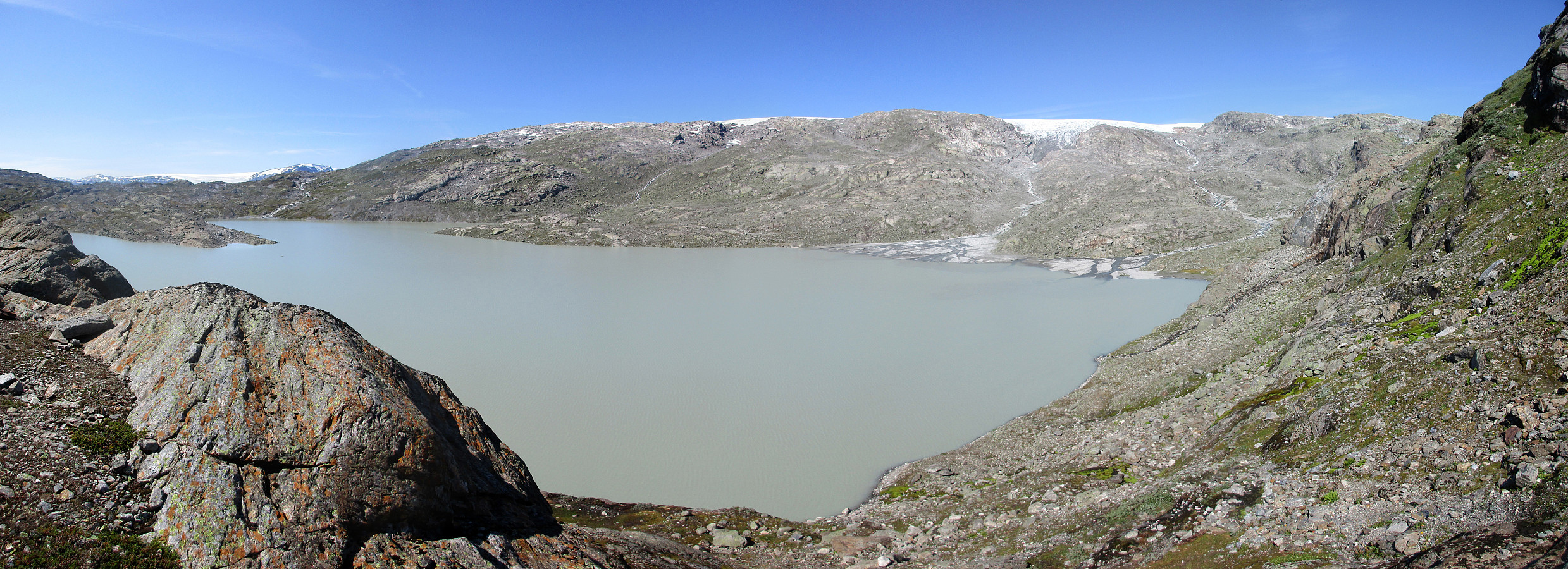
Via Leirvatnet to Gravdalsvatnet
The trail then continues further eastwards (while Mørkrisdalen extends towards the south) and brings one to a small saddle (between Løndøla in the west and Nobbelvi in the east). Finding a nice little lake close to this saddle, we refreshed ourselves (again, we enjoyed a beautiful and warm summer day!). A bit further along the marked trail, one can step over Nobbelvi using a bridge (very, very useful!). Then, the trail continues in parallel to Leirvatnet further eastwards. Leirvatnet is an interesting lake: it is fed by glacial waters from Harbardsbreen (right in the north of it), turning its water into a grayish, opaque color! Also, one can see large deltas forming where the glacial waters run into the lake, depositing a lot of sediment. On the eastern side of Leirvatnet, the trail climbs steadily up to the main saddle of this connection between Arentzbu and Nørdstedalseter (at about 1380mosl). From there, one hikes (at large) downwards through Gravdalen for about 100 height meters towards the north of Gravdalsvatnet.
Down to Nørdstedøla
While still "rounding" Gravdalsvatnet in its north, one makes a last ascent, before stepping (steeply!) down to Nørdstedøla. This descent of about 300 height meters is very steep, offering some stunning views into Nørdstedalen! With a bit of caution, however, it's no problem to safely getting down to Fivlemyrane kraftstasjon, right next to the dam that holds back an artificial lake at Fivlemyrane. Once down there, the rest of the hike is a bit boring, following the gravel road down to Nørdstedalseter.
End of Day 3
After this nice and warm hiking day #3, we enjoyed the full-service cabin Nørdstedalseter, getting ready for day #4 of our five days hike through Breheimen. Hint: If you get there on a warm day, as we did, you clearly should check out the "kulp" (just a few meters down from the cabin), which is part of the stream coming down from Middalen: it's awesome! :-)
Photos
Selected photos are available as Google photo album.
Useful Resources
See also the related FB-page Hiking around Bergen, Norway.
The National Park Breheimen has its own home page.
Web page UT.no from the Norwegian Trekking Association recommends the same route from Arentzbu to Nørdstedalseter.

User comments