
Livarden from Haukelandsvatnet (27.07.2025)

Geschrieben von HHauser (Helwig Hauser)

| Startpunkt | Unnelandsvegen (85m) |
|---|---|
| Endpunkt | Unnelandsvegen (85m) |
| Tourcharakter | Wanderung |
| Tourlänge | 4h 00min |
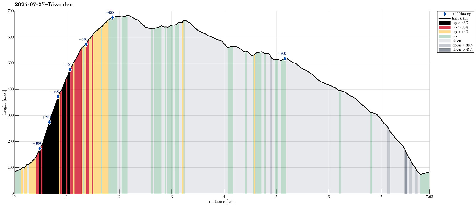
| Entfernung | 7,9km |
| Höhenmeter | 725m |
| GPS |
|
| Besteigungen | Livarden (683m) | 27.07.2025 |
|---|---|---|
| Besuche anderer PBE | Laksevåg Røde Kors Hjelpekorps' hytte (556m) | 27.07.2025 |
| Livarden Bautastein (635m) | 27.07.2025 | |
| Stallafossen (195m) | 27.07.2025 | |
| Ulvursvarden (677m) | 27.07.2025 | |
| Unnelandsvegen parkering (75m) | 27.07.2025 11:45 |
Trip Summary
We wished to use (part of) the nice Sunday for a nice hike and chose Livarden, not far from Bergen. Instead of the usual hike (from Totland), we decided to approach it "direttissima" from Haukelandsvatnet. We parked in the southeast of Nygardsvika (langs Unnelandsvegen) and started in easterly direction -- to pass by (and below) Kalvehalsen. For a bit, we followed a (faint) trail, which leads up to a small building south (and above) Kalvehalsen. Instead of following this trail for any longer part, however, we quickly aimed at Stallafossen (there wasn't much to see or hear of this waterfall, though -- probably due to the rather dry perdiod during the past days). The goal was to ascend to a ridge in the south of Stallafossen (the first "big" one on the westside of the stream). The terrain is substantially steep in this section and one needs to carefully choose, where to actually step. At times, we had to also use our hands in addition to help us up the most steep sections. Not necessary to mention that there's no trail. Once up to about 500 masl, though, we had managed the steepest sections and further progress was much more "straight forward" (still upwards quite a bit). It then did not take us too long to make it "all the way" up to Nordvarden. After a short, nice lunch break, we then passed by the big cairn of Livarden, aiming at Krokvatnet and Bautasteinen in the southeast of the top. We then surrounded the little lake on its eastern, southeastern side, before aiming back up to the main (southern) ridge of Livarden. The goal was to walk around Ulvurslia (in its south), before then heading back to connect to the "Rett Vest" trail at Seterhaugen. All this went very well and nicely -- one just needs to watch out regarding the best way to get from Ulvursdalen to Seterhaugen. Once there, it was then just to walk out down the "Rett Vest" trail (it's a bit steep in its lower parts, and it can be slippery there, too, especially in wet conditions). All in all, we returned highly satisfied from this nice hike! :-)
Photos
Selected photos are available as Google photo album.
Useful Resources
See also the related FB-page Hiking around Bergen, Norway.
Petter Bjørstad has a useful page about Livarden and also web page WestCoastPeaks.com provides useful information about Livarden.
Web page UT.no from the Norwegian Trekking Association recommends a much easier hike to Livarden (from Totland).


Benutzerkommentare