
Steinfjellet from Osavatnet (via Vossavardane) (09.06.2025)

Geschrieben von HHauser (Helwig Hauser)

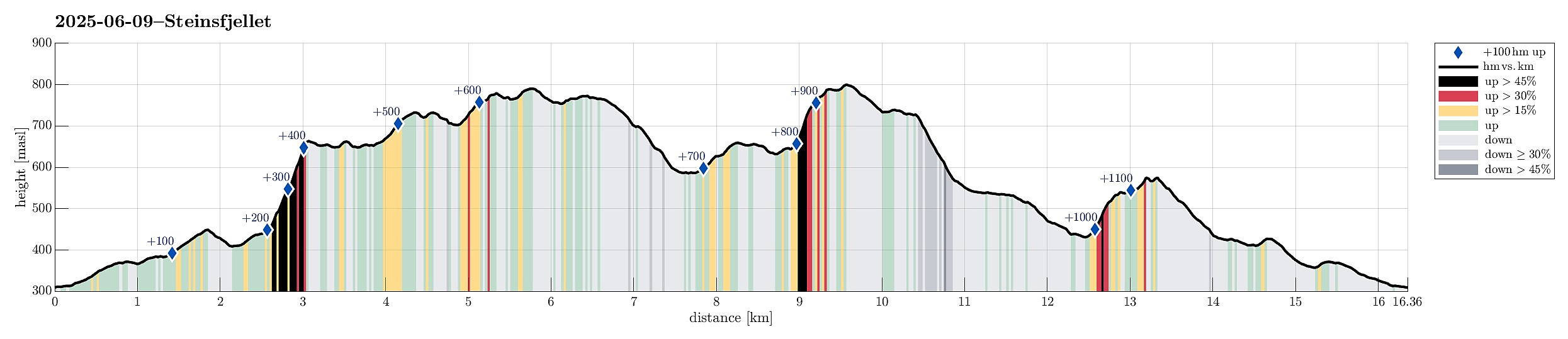
| Startpunkt | Osavatnet (310m) |
|---|---|
| Endpunkt | Osavatnet (310m) |
| Tourcharakter | Wanderung |
| Tourlänge | 7h 00min |
| Entfernung | 16,4km |
| Höhenmeter | 1.190m |
| GPS |
|
| Besteigungen | Hotten (668m) | 09.06.2025 |
|---|---|---|
| Høgevarden (781m) | 09.06.2025 | |
| Småhaugane (579m) | 09.06.2025 | |
| Steinfjellet (661m) | 09.06.2025 | |
| Vossavardane NV (736m) | 09.06.2025 | |
| Øst for Vossavardane (803m) | 09.06.2025 | |
| Vossavardane, M (793m) | 09.06.2025 | |
| Vossavardane, S-1 for NV (735m) | 09.06.2025 | |
| Besuche anderer PBE | Heniehytten (ruin) (313m) | 09.06.2025 |
| Osavatnet p-plass (kr) (310m) | 09.06.2025 |
Trip Summary
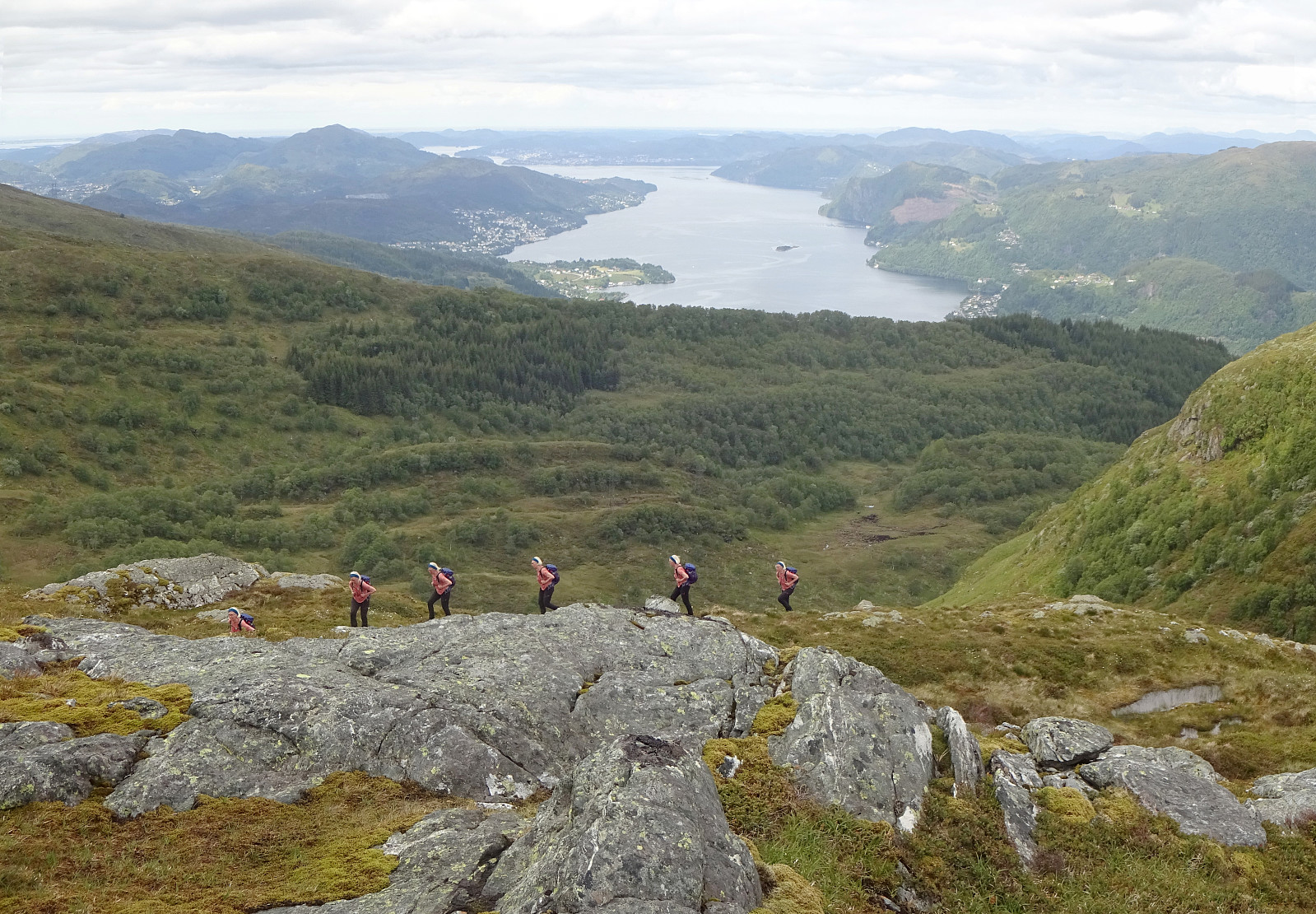
We decided to make a hike to Steinfjellet in the east of Gulltjørna. After comparing different approach options, we decided to hike Steinfjellet from Osavatnet (via Vossavardane). This gave us also the opportunity to explore the direct ascent to Vossavardane from Songstaddalen via Gasebrekkene. After parking near Osavatnet, we thus first hiked into the direction of Songstaddalen (northwest of Svartavassrinden). From Songstaddalen, we then entered the lower stretches of Gasebrekkene (steep, yes, but well doable -- without a trail, of course). Getting up to the saddle between Hotten in the south and Tjørndalsskaret in the north proved well possible, while steep as expected. The only one point to consider is that it's not all that clear how to avoid a bush war up there (possible, but one needs to actively avoid it). Once on the saddle, we decided to pay Hotten a short visit, before then ascending via a nice ridge to Tjørndalsskaret. From the heights in the west of Tjørndalsskaret (and via Tjørndalsskaret), we then continued to Vossavardane (Høgevarden first). Once on the highest point of Vossavardane, we had another short discussion about the continuation of the hike: call it a day, or continue towards Steinfjellet. With the decision to continue towards Steinfjellet, we headed towards Gråfjellet. After first stepping down to Snøskaret on Gråfjellet, we then descended to Gulltjørna via the eastern slope of Gråfjellet. On the other side, we then made it up to Steinfjellet via its northern side. Crossing over Steinfjellet was then straight forward and esay. The next question was: what's the best way to get up to the heights in the south of Gulltjørna? We first had considered a small valley coming down west-east from there, but then saw that this valley is cut in a bit too much to be a comfortable option. Instead, however, we could see a nice option a bit north of the valley, following a grass arc (steep, yes, but nicely possible without a need to do any climbing). Soon we had made it up to the heights so that we could start our descent to Tjørnane on the other, southwestern side. Further down, we then also connected to the trail that would bring us down into Tjørndalen via Tjørnane. In Tjørndalen, we enjoyed a short break, before continuing along the trail to Smettet. There, however, we decided that it was just too tempting to also include a short visit to Småhaugane a bit further south (without trail). After making it to the southern side of the valley that form the lowest part of Glamregjelet, we then made it up to Småhaugane without any difficulties, enjoying some nice views from up there. Avoiding the steep southwestern side of Småhaugane, we instead stepped down in southern direction, connecting to the trail that comes down from Markskilfossen there. Following this trail, we then made it quickly to the gravel road that comes down from Redningshytten. Not much later, we then also arrived back at the parking lot near Osavatnet, very satisfied with this nice (slightly longer) hike! :-)
Photos
Selected photos are available as Google photo album.
Useful Resources
See also the related FB-page Hiking around Bergen, Norway.


Benutzerkommentare