Archiv - Nach Datum
Archiv - Nach Aktivität
-
Andere Tour (5)
- Expedition (5)
-
Andere Wintertour (5)
- Schneeschuhtour (5)
-
Fußtour (507)
- Bergtour (205)
- Hochtour (47)
- Jogging (4)
- Spaziergang (55)
- Wanderung (196)
-
Klettern (43)
- Alpinklettern (31)
- Eisklettern (3)
- Klettersteig (1)
- Mixed-Klettern (1)
- Sportklettern (3)
-
Skitour (449)
- Langlauf (2)
- Randonnée/Telemark (441)
- Tourenskilauf (4)
Peakbookfreunde


Derwentwater to Langdale
- Datum:
- 13.12.2009
After what had been a weekend of crisp and gorgeous weather, today was by comparison a bit disappointing and overcast. Nevertheless it meant that it was also a bit milder too and it wasn't raining at least! So from Derwentwater youth hostel I took the track up to Watendlath via Ashness Bridge, passing a couple of farms and bored-looking cows and sheep along the way, and when I got to Watendlath it was quite deserted. I guess that's winter in the Lakes. No tourists to demand tea shops should be open! Anyway, from there it was up onto High Tove, to gain the ridge above Watendlath, and a somewhat but not very boggy trudge across Long Moss and by the edge of Blea Tarn to access Standing Crag and Ullscarf. This is probably my least favourite fell; its a very tedious trudge up a very tedious and >>>
Coledale round
- Datum:
- 12.12.2009
A great day out with some friends I went to the Himalaya with from the previous November in 2008, Ian and Lorraine Brookes. Sue Jeffrey, whom I'd met at the Adventure Peaks meet 2 weeks previously also joined from Dumfries for the day. I walked into Keswick to meet Sue, from the youth hostel at Derwentwater (Barrow House Bay) which is now no longer a YHA hostel sadly. Anyway, me and Sue met up at Booth's supermarket and then headed out to Braithwaite at the high car park just outside of the village. Ian and Lorraine joined us there, and we were soon out and up on Grisedale Pike, enjoying the crisp and clear conditions with a touch of frost underfoot. Great views down over Keswick and out east toward Blencathra and Skiddaw, and the Helvellyn Ridge......It was sunny for pretty much the whole >>>
Stony Cove Pike
- Datum:
- 28.11.2009
After a long-ish drive up to Windermere from Leicester the previous evening, we woke up to a fresh covering of snow all over the fells. Exciting for everyone who was coming for the Adventure Peaks Christmas party, (even though it was admittedly still a bit early for Christmas celebrations) we drove up to the car parking place at the top of Kirkstone Pass, opposite the inn and began the walk at about 10am. At first the weather was dry but quite misty so there was not much to see apart from a lot of whiteness, and it remained like that all the way over Pike How to Stony Cove Pike. No views, chilly and a bit boring. Once we'd descended down Threshthwaite mouth into Pasture Beck it was just a bit drizzly but warmer and we were down at Hartsop in the early afternoon and walked back along the road >>>
Langdale
- Datum:
- 09.11.2009
To start the day I had an absolutely beautiful drive from Grasmere to Langdale via the High Close road in crisp and cold conditions. Frost was accessorizing the strands of grass and a cool temperature inversion kept some low level mist nearly down to ground level. The walk itself was not exciting, but the views and sunny weather made it a very good day out, cut short only by the fact I had to be on the road ideally by 4 pm to make my way down to Aberystwyth so unfortunately I didn't complete the circuit by going all the way over to Esk Hause and onto the Langdale Pikes. After Bowfell it was a descent down to Ore Gap and then on to Angle Tarn, returning to Langdale via the steep steps down into Mickleden and along the valley bottom.
Scafell Pike with Mum
- Datum:
- 29.08.2009
Bank holiday weekend was spent taking Mum on our annual trip to the Lakes together; this weekend was unfortunately not blessed with the most fantastic weather ever, and on the Saturday we drove to Seathwaite from Borrowdale youth hostel to join several other parties of walkers who were making the trudge up to the top of England's highest despite the miserable and dreary wet weather. Surprisingly my Mum, even though not a hiker - didn't complain once. Even I didn't find the walk up Grains Gill particularly inspiring with the lack of views, but we carried on anyway. By the time we'd passed Sprinkling Tarn and gotten up to Esk Hause the wind was blowing really rather strongly and I was cold enough to need to put on extra layers. Probably wearing more on the summer bank holiday weekend than I sometimes >>>
Hamperokken
- Datum:
- 05.08.2009
- Tourcharakter:
- Wanderung
I did this trip with some friends during the EISCAT workshop being held in Tromso. Since there was an afternoon free without any seminars or talks and the weather was forecasted to be warm and amzing all week, we were all psyched up for doing a mountain hike, especially since the three of us had climbed and summited Mont Blanc together only a few weeks earlier. Hamperokken was our destination of desire, and we managed to convince a few other workshop friends to join us too, which was also quite handy because they had a car after having driven from Sodankyla in Finland to Tromso. It was quite an unpleasant start to try and get up and out of the forest and at times too unenjoyable to want to carry on with the hike, especially since the temperature was in the 20s and there were lots of midges around >>>
Mont Blanc
- Datum:
- 15.07.2009
- Tourcharakter:
- Hochtour
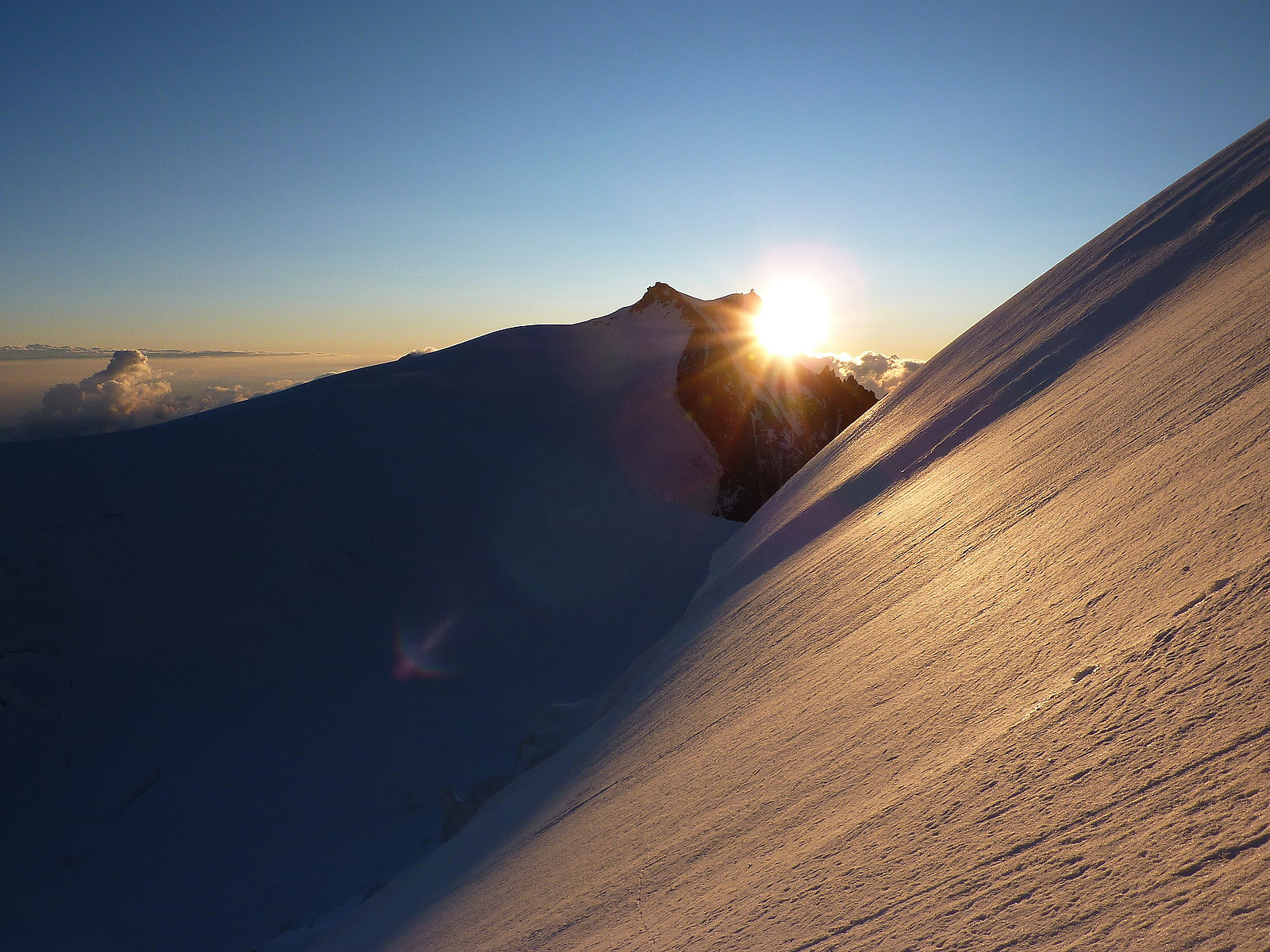 Wednesday, 15th July 2009
Bumming around in the morning and generally not rushing around was quite nice after 2 days of early starts. In fact, 10am actually came round pretty quickly and we were soon met at the apartment by our guides Hannah and Anthony to make the drive over to Chamonix (yes, it became something of a joke that there were actually three Hannahs in a group of 6). The general plan was to have lunch in Argentiere and then continue to the Aiguille du Midi station in Chamonix. Surprisingly it took less time to travel by car than it did when we took the Mont Blanc Express train, despite all the switchbacks in the road which probably made the route longer. It was about midday by the time we parked up in Argentiere and we sat at some park benches to eat our sandwiches. Chamonix was >>>
Wednesday, 15th July 2009
Bumming around in the morning and generally not rushing around was quite nice after 2 days of early starts. In fact, 10am actually came round pretty quickly and we were soon met at the apartment by our guides Hannah and Anthony to make the drive over to Chamonix (yes, it became something of a joke that there were actually three Hannahs in a group of 6). The general plan was to have lunch in Argentiere and then continue to the Aiguille du Midi station in Chamonix. Surprisingly it took less time to travel by car than it did when we took the Mont Blanc Express train, despite all the switchbacks in the road which probably made the route longer. It was about midday by the time we parked up in Argentiere and we sat at some park benches to eat our sandwiches. Chamonix was >>>

