Archiv - Nach Datum
Archiv - Nach Aktivität
-
Andere Tour (1)
- Kayaking (1)
-
Andere Wintertour (4)
- Schneeschuhtour (4)
-
Fahrradtour (137)
- Fahrradtour Straße (9)
- Fahrradtour gemischt (51)
-
Fußtour (740)
- Bergtour (363)
- Jogging (18)
- Spaziergang (89)
- Wanderung (270)
-
Skitour (4)
- Tourenskilauf (4)
Archiv - Nach Geografie
Peakbookfreunde


Gesammelte Listen
-
Bergen ≥ 50m pf. og ≥ 100 m.o.h.
(87/89)
 97%
97% -
Most dominating tops of the Bergen peninsula
(68/75)
90%
-
Utvalgte topper og turmål i Bergen
(316/350)
90%
-
Alle topper i Bergen
(357/398)
89%
-
Opptur Bergen
(100/113)
88%
-
De syv fjell rundt Bergen
(6/7)
85%
-
Sund ≥ 50m pf.
(14/18)
77%
-
Os ≥ 50m pf.
(25/34)
73%
-
Søyler (fastmerker) i Bergen
(68/100)
68%
-
Fjell ≥ 50m pf.
(21/32)
65%

Furekampane & Skavdalen
- Datum:
- 21.11.2015
- Tourcharakter:
- Bergtour
- Tourlänge:
- 3:00h
- Entfernung:
- 8,1km
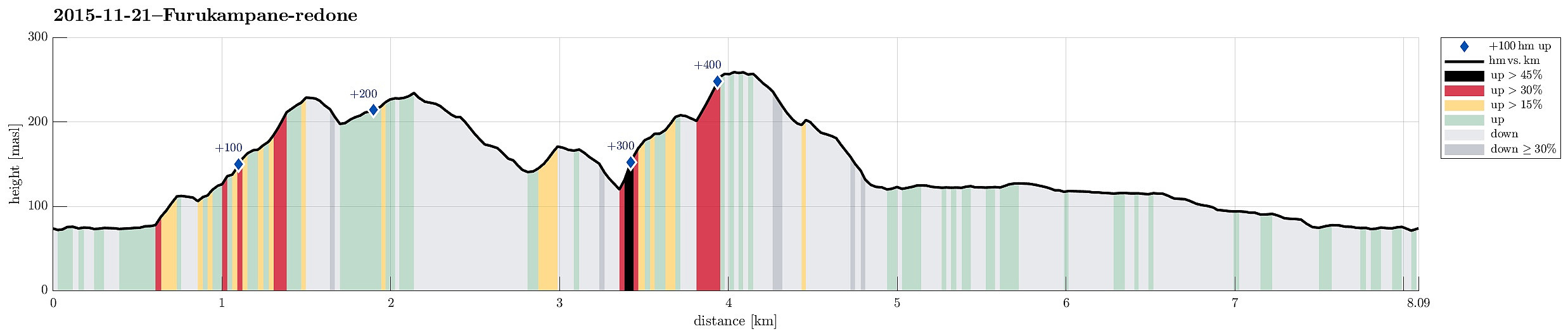 We parked near Dyngelandsvatnet and rounded the small lake on the southeastern side, then ascending to Fjellsenden. From there, we basically walked all over the long ridge of Furukampane. On the other end, at Ravnabrotet, we got to look down on Grimevatnet. From there, we turned right and back, a little, descending into Skavdalen (and crossing it close to the northern end of a small lake which is located right underneath Langavatnet). We climbed up on the eastern side to Øvre Skavdalen and from there further to a small top underneath Brattlandsfjellet. There we turned back, descending again into Øvre Skavdalen and from there back to the small lake (but now to its southern end). From there, it is only a few steps to the northern end of Langavatnet and a path leads along this lake on >>>
Liatårnet and Høgafjellet
- Datum:
- 15.11.2015
- Tourcharakter:
- Bergtour
- Tourlänge:
- 2:45h
- Entfernung:
- 8,4km
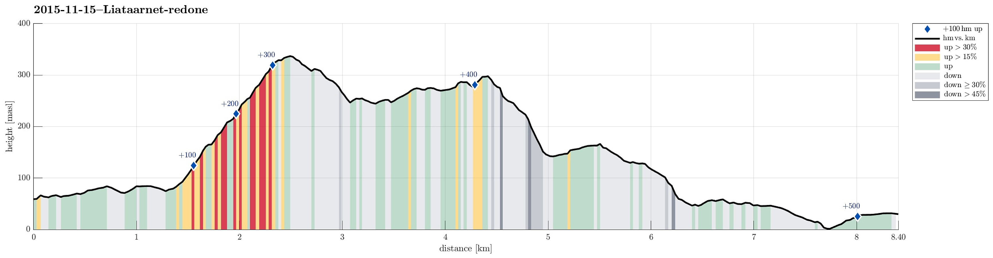 We parked south of Fjell, where a road departs, leading to Fjell Festning. We followed this road for a bit, before we continued towards Liatårnet (to the right). Someone has put significant efforts into putting signs up and marking the path, so it's really straight forward now to find the path up Liatårnet. :-) From Liatårnet, we enjoyed nice views in all directions, before we continued southwards towards Høgafjellet. After the first descent, we probably followed an older path, before we connected back to the blue-marked path towards Høgafjellet. The path from Liatårnet to Haganes, via Høgafjellet, is really very nice with great views and rough, wild romantic impressions. Before walking out towards the road near Haganes, we descended to a half-high level. We were wondering, whether >>>
Knappen
- Datum:
- 08.11.2015
- Tourcharakter:
- Spaziergang
- Tourlänge:
- 1:00h
- Entfernung:
- 4,3km
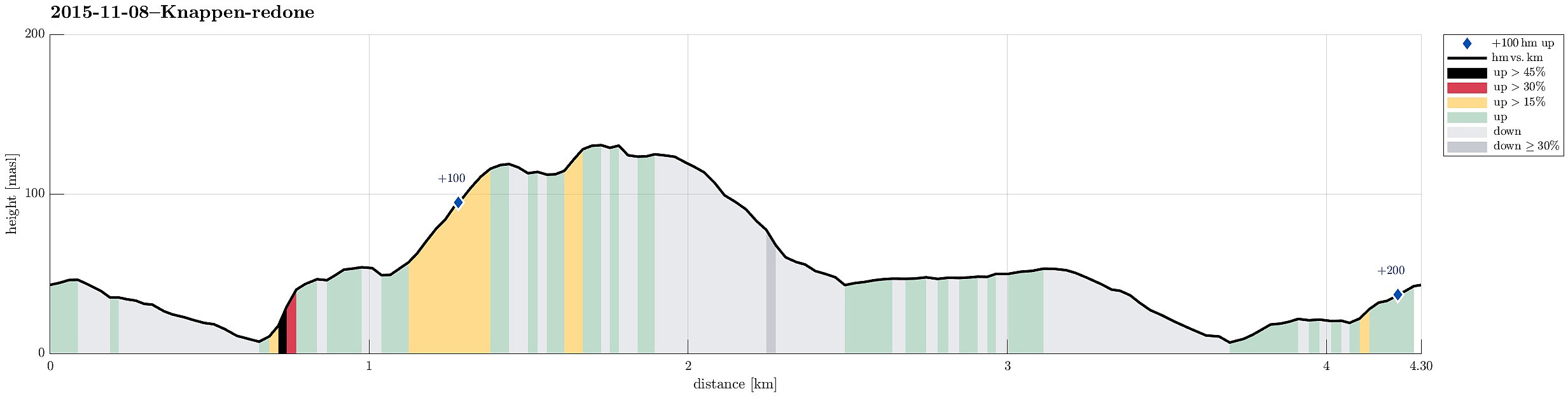 From Varden, we walked over the bridge over Bjørgeveien and then up to Knappen. Back, we descended on the east and north of Knappatjørna, before returning to Varden.
Petter Bjørstad has a useful page about Knappen .
From Varden, we walked over the bridge over Bjørgeveien and then up to Knappen. Back, we descended on the east and north of Knappatjørna, before returning to Varden.
Petter Bjørstad has a useful page about Knappen .
Storevarden
- Datum:
- 07.11.2015
- Tourcharakter:
- Bergtour
- Tourlänge:
- 1:00h
- Entfernung:
- 3,6km
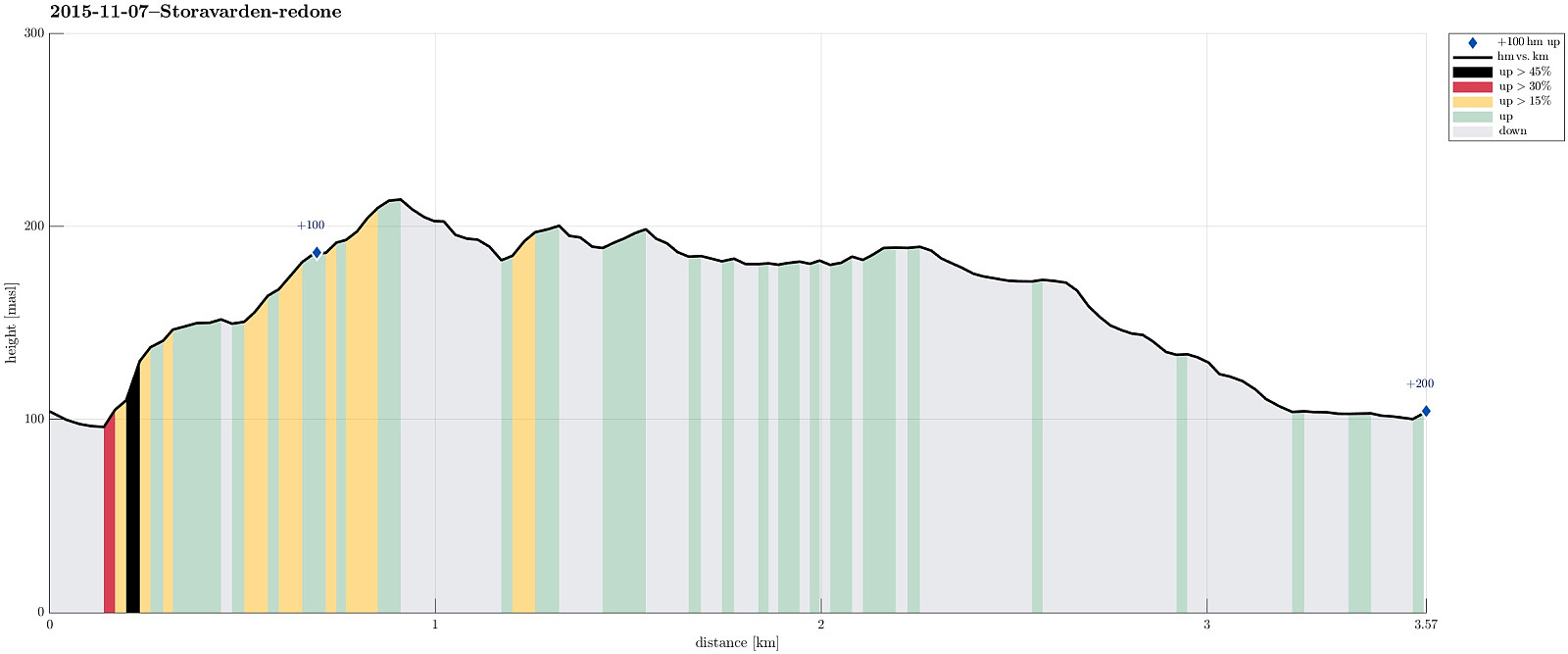 We parked along Bergheimvegen (near Skogedalen) and walked a few meters along the road (towards East), before we found the path up towards Storevarden (on the left). Within a few minutes, we reached a ridge that easily leads towards Storevarden. From there, one has a nice view over Byfjorden and Bergen. We then continued towards Langafjellet (one should take care to not start too much to the East, where a nice ridge invites to be followed---instead, one should look out for a small path that leads downwards, before connecting to Langafjellet). On the other side of Langafjellet, we connected back to a place, which we have visited recently---right next to a very nice small lake. From there, we basically turned back (on the "main path", however, that is a little to the West of the >>>
Sydpolen
- Datum:
- 18.10.2015
- Tourcharakter:
- Bergtour
- Tourlänge:
- 4:30h
- Entfernung:
- 14,6km
 We parked at the end of Hausdalen and started with walking in Brekkjedalen (until a height of about 260mosl). Basically, where a power line mast stands close to the gravel road, a path diverts to the left, marking the beginning of the ascent to Sydpolen. Down in Brekkjedalen, late morning frost was still omnipresent, but after only a few meters of our ascent over the ridge upwards, we "entered" the sun and enjoyed a beautiful autumn day! It took us 60 mins. from the gravel road and up to the top of Sydpolen---not too bad, maybe! :-) From Sydpolen, after a short break, we continued in northeastern direction, rounding Gullfjelltjørnane in a counterclockwise manner. Near Gullfjellet (not Gullfjelltoppen), we connected to the main path that leads up and down Gullfjellet via Redningshytten. >>>
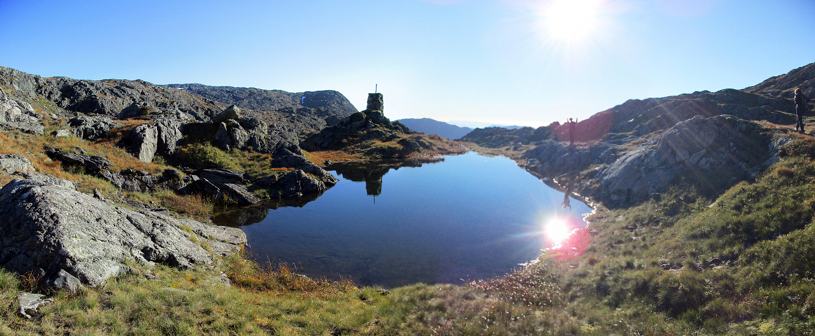
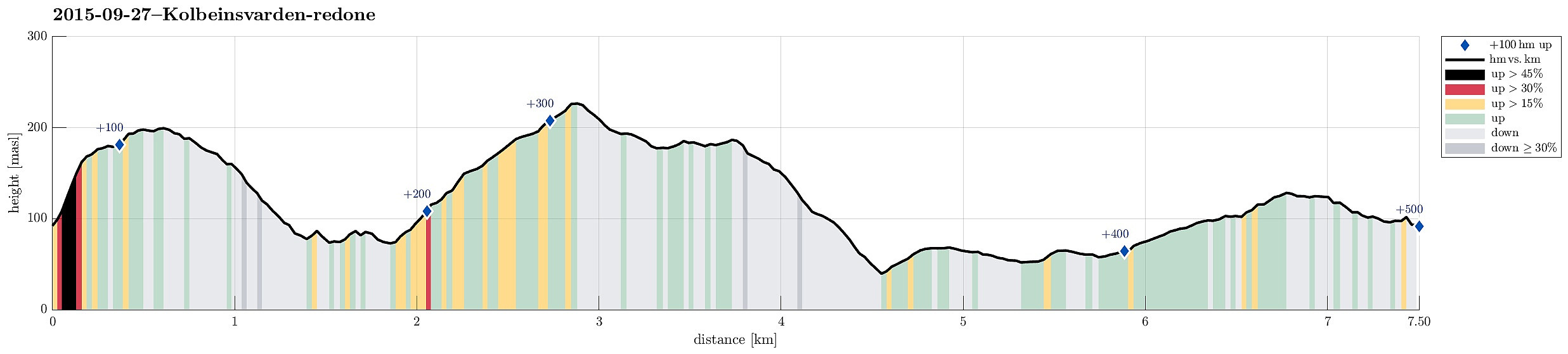
Kolbeinsvarden
- Datum:
- 27.09.2015
- Tourcharakter:
- Bergtour
- Tourlänge:
- 2:30h
- Entfernung:
- 7,5km
 Aiming for a quick sunday afternoon hike, we drove to Askøy and found our way to Bergheim. Only a few meters into Bergheimsvegen, we found a place to stop and a path that would lead to Kolbeinsvarden. Instead of directly going there, however, we first ascended to Birkafjellet, which is a nice cliff right over Kleppe with great views! From there, we followed the path northwards (and downwards) until we came to a fence that protects Kleppevatnet. The path continues right next to the fence and we followed it further, searching for the right spot to ascend to Kolbeinsvarden. After a short detour -- basically, we followed the path along the fence a little too far, we found the (pretty well visible) path and ascended through a nice little valley up to the heights right underneath Kolbeinsvarden. >>>
Lyshornet
- Datum:
- 26.09.2015
- Tourcharakter:
- Bergtour
- Tourlänge:
- 2:00h
- Entfernung:
- 8,9km
 We parked right next to Pøyla/Kalvatræ and followed the gravel road that leads up to Svartavatnet/Ulvvatnet, first. That's an easy walk and one passes a point, maybe 200m before getting to the dam, where one can enjoy a really nice view over Lysefjorden! Once at the dam, one could continue on a smaller path (on the western side of Svartavatnet/Ulvvatnet), but we turned around and followed the gravel road that we had walked up, first. About half way back, right underneath Geithaugen in the west, and at about 145mosl, a nice path towards Lysehornet leaves (to the east). We followed this path (via Grønhovda) to Lysehornet and enjoyed the great views that one has from there. From Lysehornet, we descended via the other path, which leads (via Lyshornskaret) to the ruins of Lyseklosteret. >>>
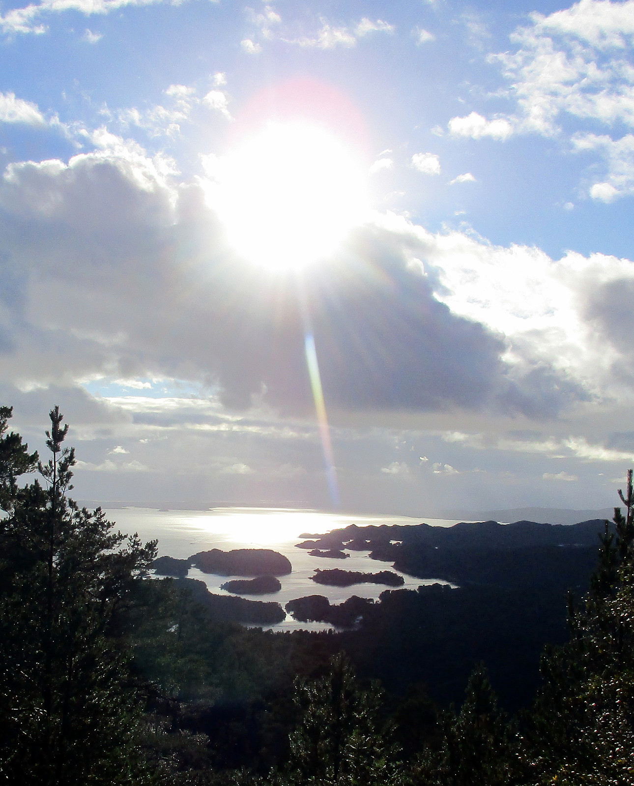
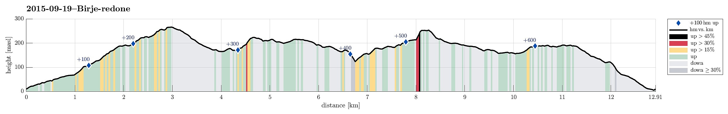
Birje
- Datum:
- 19.09.2015
- Tourcharakter:
- Spaziergang
- Tourlänge:
- 3:00h
- Entfernung:
- 12,9km
 Starting from a place near Øydvenstod, I first followed Osavegen up to the saddle towards Ulvik. There, I turned left, westwards, and ascended the few meters up to Håheim. From there, I followed the marked path -- in southwestern direction -- in order to get up to Åsen. It's not so clear, where the top actually is -- Åsen is well-covered with a forest and there are a number of ups and downs. I found my way to the antenna that is also seen from Ulvik and from there, via a simple path, down to Vattatveit. From there, I first followed the forest road, but when it turned left -- in eastwards directions -- I left it (to the right) and crossed Trånemyrhaugen (basically without any path). I crossed another forest road and continued (without path), this time up Vetlefurehaugen. On the other >>>
Lyderhorn
- Datum:
- 17.09.2015
- Tourcharakter:
- Fahrradtour gemischt
- Tourlänge:
- 2:00h
- Entfernung:
- 13,0km
 Quick excursion to Lyderhorn: First with the bike along Bjørgeveien and up to the new highway crossing near Liavatnet; then from there, walking, westwards and up in the direction of Grøvledalen (between Skarpafjellet and Lyderhorn). From the saddle, basically right underneath the power lines, then northwards and towards Lyderhorn. After a bit of up and down, the actual ascent to Lyderhorn is steep and nice. Down from Lyderhorn, I first followed the path that connects to Kjøkkelvikveien, further down, in the west of Lyderhorn, but before actually turning right in order to descend towards the west, I turned left (and towards the east), searching a connection to the path that I had taken up. I found my way, but mostly without a path, though. I followed that path I had take up (from Skarpafjellet) >>>
Store Kongshaugen & Harafjellet -- another bicycle round
- Datum:
- 05.09.2015
- Tourcharakter:
- Fahrradtour gemischt
- Tourlänge:
- 2:00h
- Entfernung:
- 24,7km
 Let's get some fresh air in the nice weather -- even if there isn't much time! :-) On my bicycle and off towards the west! :-) In Loddefjord, I turned left (and southwards) and passed by Håkonsvern. Right afterwards and shortly before Mathopen, I turned right and started my short but (very) steep ascent to Store Kongshaugen -- what a name for a comparably small hill! :-) Even though not very high, one still can enjoy great views in all directions from its top. I returned down on the same steep and old road, before then continuing via Mathopen and Hilleren towards Alvøpollen. I followed the road around Småvatnet to the sports arena of Alvøen. There I found the connection to the path that stretches along Storavatnet. From this path, I made a short detour up Harafjellet (also a rather >>>
