Molden from Marifjøra (up via Svåi) (28.06.2024)

| Startpunkt | Marifjøra (5m) |
|---|---|
| Endpunkt | Marifjøra (5m) |
| Tourcharakter | Wanderung |
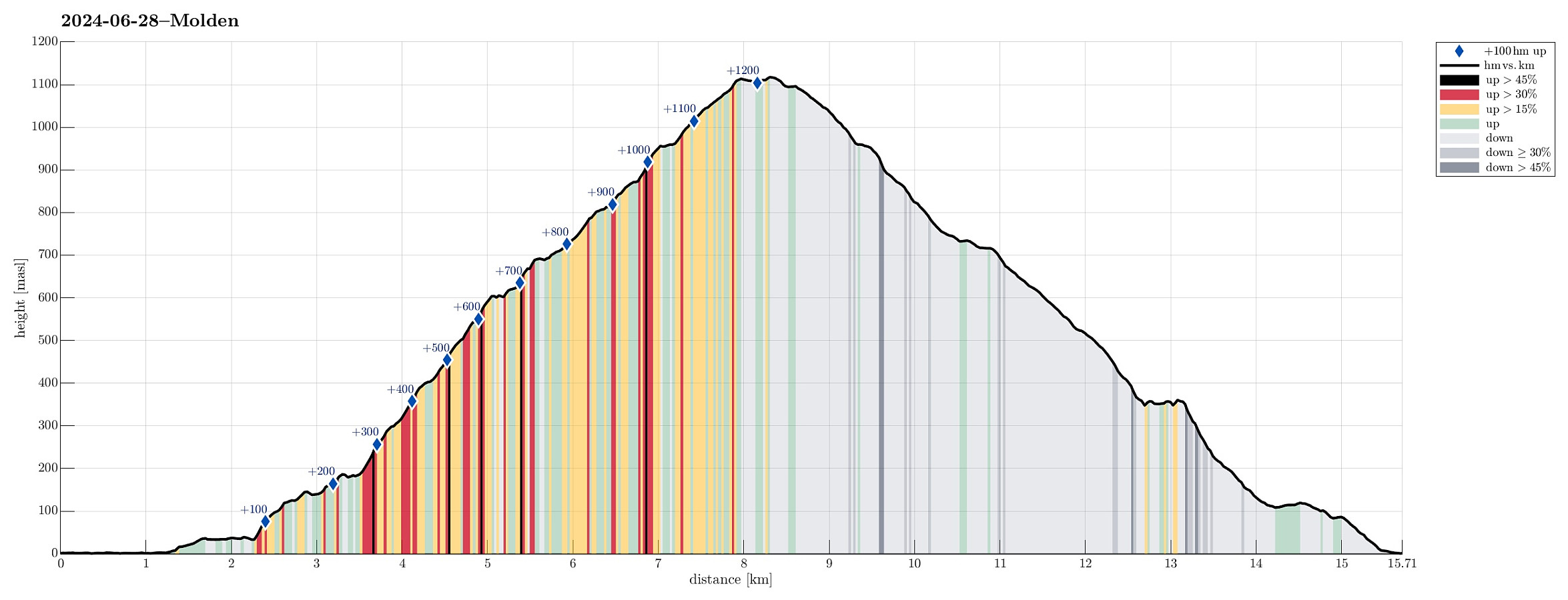
| Tourlänge | 5h 30min |
| Entfernung | 15,7km |
| Höhenmeter | 1.284m |
| GPS |
|
| Besteigungen | Molden (1.120m) | 28.06.2024 |
|---|---|---|
| Besuche anderer PBE | Gråfjell (865m) | 28.06.2024 |
| Marheimsholten (355m) | 28.06.2024 | |
| Varden på Molden (1.116m) | 28.06.2024 | |
| Steinbua på Molden (1.114m) | 28.06.2024 | |
| Utsikten (620m) | 28.06.2024 |
Trip Summary
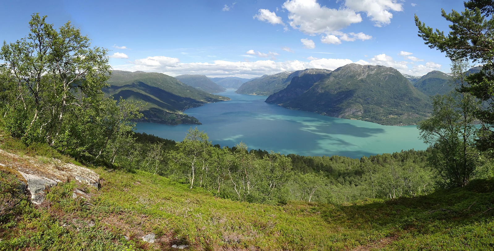
We left Bergen early in the morning with a plan to start hiking around noon-time. The plan was to hike up to Molden. After searching a little here on Peakbook, we got inspired by Jørn Håvard Ask, who wrote in his trip report "trip report" that hiking Molden from the north was really good! :-) We thus drove to Marifjøra, where road #55 (Lustravegen) comes down to meet Gaupnefjorden (only a few kilometers before reaching Gaupne). The idea was to leave the car there, ready to be picked up after coming down from Molden in Marifjøra, and then first walk Eikjastrondsvegen (along Gaupnefjorden) to the southeast and the start our ascent near Svåi. After about 2km on Eikjastrondsvegen, we found a trail-head for Molden, just meters before reaching Svåi. The original plan had been to first walk up to the highest house at Svåi, before there finding a marked trail that would lead up the high-ridge above Raudakleivi. The trail, which we found, however, lead up to Steinkveane, first, and from there further up to Molden. We still started to follow this trail. At about 125 masl, however, we found a piece of information that suggested that we could connect to the originally planned trail via a differently marked trail (blue markers, instead of the otherwise red ones). Following this "blue trail", basically on level height, we indeed got "over" to the trail above Raudakleivi. Further up this trail, we also were promised some nice views over Lustrafjorden (by a sign to "Utsikten"). Stepping up towards "Utsikten" along this red-marked trail was then straight-forward (steep, yes, but on an excellent trail). Just above 600 masl, we then found "Utsikten" (well marked, straight-forward to find) and enjoyed a short break there. From "Utsikten", however, we had cooked up an alternative route (than what following the red markers would have provided). The idea was to further ascent some 100 height meters in the southwest of "Utsikten" (without a trail) and then find another trail, which is shown on the map, that leads "diagonally" upwards on a high ledge (in northwestern direction). The expectation was that we would enjoy nice views from up there. :-) We indeed found a very reasonable connection to this other high-point above "Utsikten" (even though the terrain is certainly steep there). Once on the ledge, however, making progress along it was mostly straight-forward again. The promised trail, however, was very hard (or not at all) to see. Also, at one point, or two, some improvisation was required to make further progress (not really difficult, though). Once up to about 815 masl, we made (almost) a 180 to get further up to Gråfjellet. Up there, a simple trail was visible, even. :-) At about 865 masl, however, we started to distrust this trail and decided to "short-cut" in southwestern direction (rather steeply upwards) to get the main trail, which connects Marifjøra with Molden. Once on this trail, stepping further up to Molden was then straight-forward. We then made "the obligatory short round" on the top of Molden to not only include the nice, big cairn, but also Steinbua and the actually highest point on Molden. Back down from Molden was then just a matter of following the main trail to Marifjøra. This trail very nicely follows a long ridge directly into the direction of Marifjøra. Down to a bit above 400 masl, however, the trail turns left (westwards), leading down to Sviggaplassane from there. A few meters down this trail, a sign invited to also include a short visit to a vista-point high above Marheim. After this short detour, it was then just down to Sviggaplassane, first, and from there, further following the trail, down to Marifjøra. All in all, this hike really was very nice!
Photos
Selected photos are available as Google photo album.
Useful Resources
See also the related FB-page Hiking around Bergen, Norway.
Petter Bjørstad has a useful page about Molden and also web page WestCoastPeaks.com provides useful information about Molden.
Web page UT.no from the Norwegian Trekking Association recommends a (kind of) similar hike.

Benutzerkommentare