Skarsnuten, Vardafjellet, Grytefjellet, and Belgjaråsen (30.04.2019)

| Startpunkt | Parking south of Skarsnuten (115m) |
|---|---|
| Endpunkt | Parking south of Skarsnuten (115m) |
| Tourcharakter | Bergtour |
| Tourlänge | 5h 45min |
| Entfernung | 14,8km |
| Höhenmeter | 1.099m |
| GPS |
|
| Besteigungen | Beljaråsen (395m) | 30.04.2019 |
|---|---|---|
| Grytefjellet (808m) | 30.04.2019 | |
| Skarsnuten (410m) | 30.04.2019 | |
| Vardafjellet (771m) | 30.04.2019 | |
| Besuche anderer PBE | Skardsnuten p-plass (120m) | 30.04.2019 |
Compare, if interested, to the other report by my hiking partner Harald Barsnes (also here on Peakbook), and note that he has many useful hiking reports on his page.

Trip Summary
After a meeting at Solstrand Bad & Hotel, we decided to do a hike in nearby Fuse before heading back to Bergen. From Hattvik, we thus took the ferry over to Venjaneset and drove from there further along road 552 towards Eikelandsosen. There we took to the left (onto road 48 and into the direction of Samnanger) and continued on it for a few kilometers (until we had come through Moshovdatunnelen). Right after the tunnel, we turned right (onto Hafskorvegen) and parked soon after (very near to the bridge that we had just passed over after the tunnel).
Skarsnuten
Our first hiking goal was Skarsnuten, a little top "in the valley", south of Hafskorvatnet. It was nice that we could see the top from the very start of the hike, also. We first followed the little road that leads up to Hafskorvatnet, surrounding Husåsen on its west, but left it soon to continue on a smaller forest road that leads northwards in the west of Botnane. Steadily ascending and soon changing into a northeastern direction, we were positively surprised to find a marked trail all the way up to Skarsnuten (on the map, we had been unable to see any trail there, but both terrain and the "suddenly ending" forest road had suggested to us that possibly a trail was to be found there anyway). Skarsnuten is very steep on its southern side -- thus, the approach to its top resembled a counterclockwise spiral with most of the final stretch on the northern side of Skarsnuten. In addition to "just having hiking fun", we also ascended Skarsnuten in order to get a closer look to the west-side of Vardafjellet.
Vardafjellet
Vardafjellet is gentle on its top, but quite steep on its fjord-facing sides -- particularly also its western side has some prominent cliffs that look impossible to traverse (without climbing equipment). When looking at the map before leaving, already, we had developed a suspicion that (more or less) exactly in the east of Skarsnuten a reasonable opportunity is found for ascending to Vardafjellet. We thus descended from Skarsnuten along the same trail that we had taken up, first. As soon as were back down to the wet saddle between Skarsnuten and Vardafjellet, we joined the trail again, which we had taken up from Botnane first, and continued along it in northeastern direction. After a minute, or two, this path brought us to a fence, which we walked alongside for a short while. When the marked trail crossed the fence and turned downwards (towards Hafskorvatnet), we left it and started to ascend towards Vardafjellet without any trail. The goal was to get around a little ridge (to its northern side) and into a little valley with a small stream (down from Vardafjellet). We expected that we should be able to make quite a few height-meters in this stream's valley, before then finding an opportunity to reach the heights of Vardafjellet. Even better than expected, we even found a simple path in this valley (not marked, but clearly more than just deer tracks). This way, it was straight-forward to get higher there. After having passed a little waterfall, we soon found the expected opportunity to ascend out of the valley again (now in southern direction and towards the top of the ridge). Once up there, all the hiking got much easier (even though without any trail). Stepping higher (in very warm spring sun!), we ascended towards a place called Nysetret (between Moshovda and Vardafjellet). There, we started to have some views towards the southeast (towards Eikelandsosen), also. We continued further in northeastern direction (towards the actual top of Vardafjellet) and enjoyed a beautiful day with lots of sunshine and great views. From the top of Vardafjellet, we then enjoyed some nice views towards the east (not at the least also towards Ottanosi), and in particular also down to Stemmetjørna (with two small cabins there).
Grytefjellet
From Vardafjellet, also, we then started to have clear views to Grytefjellet, not far in the north. When judging the terrain for a possible approach to Grytefjellet, we first considered for a moment to cross over the top of Stemmehalsen (between Vardafjellet and Grytefjellet), but decided then not to do so, since it was not possible to see, how steep Stemmehalsen would be on its northern side. Instead we decided to descend (via the saddle between Vardafjellet and Stemmehalsen) towards the north of Stemmetjørna and then further to Brekketjørna from there. All this was nice and easy (even though without any trail). We soon reached a small saddle south of Brekketjørna (and west of the little stream that runs down from Brekketjørna to Stemmetjørna). From there, we rounded Brekketjørna in its east, passing by Drengjaskaret, and ascending to another small saddle north of Brekketjørna. Once there, we had some nice views towards the northeast and, in particular, to Botnavatnet there. Turning into western direction at the saddle, we continued our ascent to Grytefjellet, which was steep but easily doable there. Soon after, we found ourselves on the top of Grytefjellet and we enjoyed a number of great views in many directions from up there!
Back to Hafskorvatnet
The southern side of Grytefjellet is very steep and without climbing equipment it is meaningless to attempt any descent/ascent there. Our plan had therefore been to descend from Grytefjellet in northwestern direction. But when we looked at the situation from the top of Grytefjellet, we thought that starting our descent in western direction could be a good idea, as well. This way, we basically descended along the edge of the mountain (very steep down to our left / south) first, until we came to a little outpost (about half way down, maybe). This spot offered an amazing view (over Remavatnet and Hafskorvatnet etc.). From there, we decided to cross over Gryta in northern direction, avoiding the steep mountain side towards Remavatnet from there. Finding a very easy descent (in northern direction), we soon arrived in a small valley (coming down from Gråbotnane), where we also expected to reconnect with a trail. Even though only hardly visible (at times), we quickly found this "trail" and continued along it (now in southwestern direction) towards Remavatnet. Even though was also lost this "trail" once for a short while, we still connected to Skitnestølen near Remavatnet very soon after. From there, the trail we better visible and we continued along it into Hugnadskordalen (west of Grytefjellet). Following the trail further, we continued through Remadalen down to Gadden in the northeast of Hafskorvatnet.
Belgjaråsen
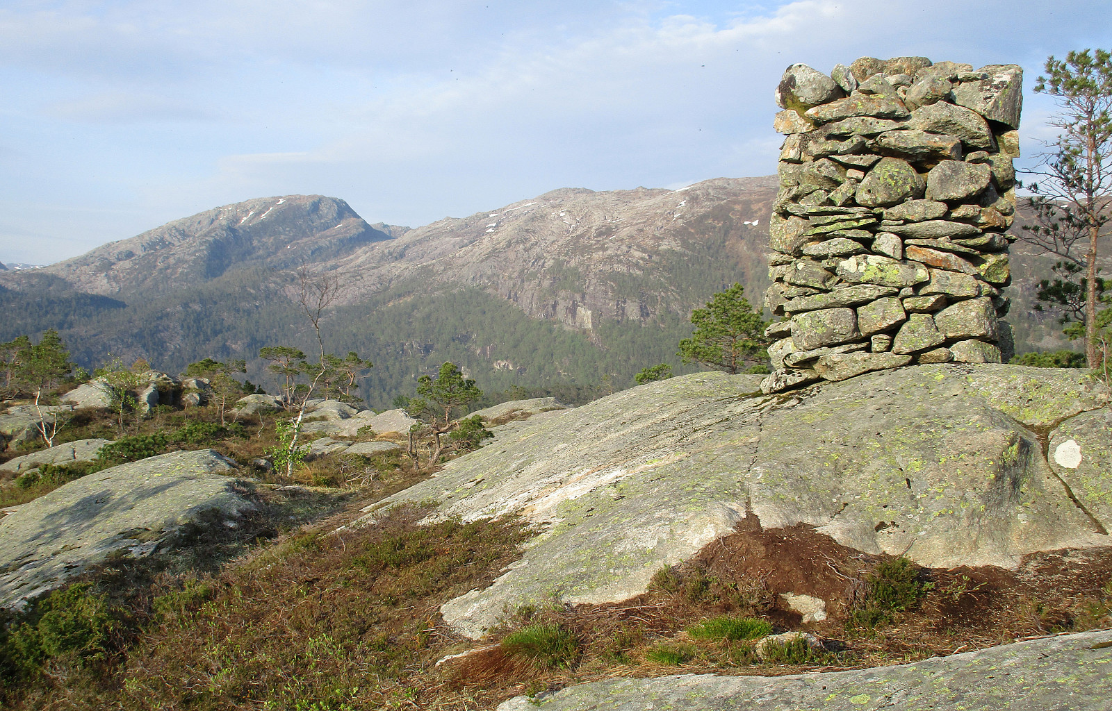
After having circled around half of Hafskorvatnet on the forest road that also continues further down towards the place where the car was parked, we decided near Eidet that we could also include Gåsdalshøgda and Belgjaråsen "on the way back to the car". At the place, where the forest road makes a sharp turn towards the south, we then saw some clear markers that lead northwards (towards Eidet). Following these markers, we soon started to descend into the valley of Matlandselva. After stepping down into this valley for a short while, we quickly understood that we were not on the path up to Belgjaråsen. Thus, we decided to leave the marked trail and ascend directly (and steeply) into southern direction and up to Gåsdalshøgda. After not too long, we again found some markers (concluding that we probably had missed the spot, where the trail to Gåsdalshøgda leaves the trail that leads into the valley). We then followed the markers (even though the "trail" was only "just so possible to find"), crossing over the wet heights of Gåsdalshøgda. Before getting over to the northern ridge of Belgjaråsen, we came to a very special place (particularly quiet), where we stopped for a moment, just to breath in and enjoy. Soon after, we were then ascending towards the top of Belgjaråsen. Even though Belgjaråsen is not really a prominent top, it still offers surprisingly nice views (and a big cairn!).
Final challenge
In order to round off, we still had to get back to the car. Somehow, we were not really motivated to go back along the marked trail (to Eidet). Thus, we decided to give a direct descent (via the southern side of Belgjaråsen) a try, even though we expected (from our map study) that the terrain should be relatively steep there. All this was then, of course, topped by the fact that we had to proceed without any trail. :-) In order to avoid the all-too-steep eastern side of Belgjaråsen, we started in southern direction and this worked well for quite a bit of the descent. From about 325mosl then, however, the whole descent was partially a fight with the circumstances (a few times we had to retreat and try some other route due to too steep terrain). Also, the vegetation is kind of dense on this mountain side, leading to some extra challenges "when breaking through". After a bit of a fight (similar to a bush war, but in the forest), we got back down to the forest road that we had left before at Eidet and followed it back to the parked car from there. All in all, this was a really nice hike in beautiful spring weather with great views in many directions. Mostly, it was reasonable (to easy) to go, even without trails for parts of the hike. The descent from Belgjaråsen "down its wild southern side", however, is not really something that most hikers will enjoy.
Photos
Selected photos are available as Google photo album.
Useful Resources
Find "the other report" about this hike, also here on Peakbook! :-)
See also the related FB-page Hiking around Bergen, Norway.
Petter Bjørstad has a useful page about Grytefjellet and also web page WestCoastPeaks.com provides useful information about Grytefjellet, Engelifjellet, and Stemmefjellet.
Web page UT.no from the Norwegian Trekking Association recommends a hike to Moshovda, which includes the same ascent to Vardafjellet that we took up.

Benutzerkommentare