
Høgstefjellet and Tellevikafjellet (02.04.2026)

Written by HHauser (Helwig Hauser)

| Start point | Hitland (85m) |
|---|---|
| Endpoint | Hitland (85m) |
| Characteristic | Hike |
| Duration | 4h 00min |
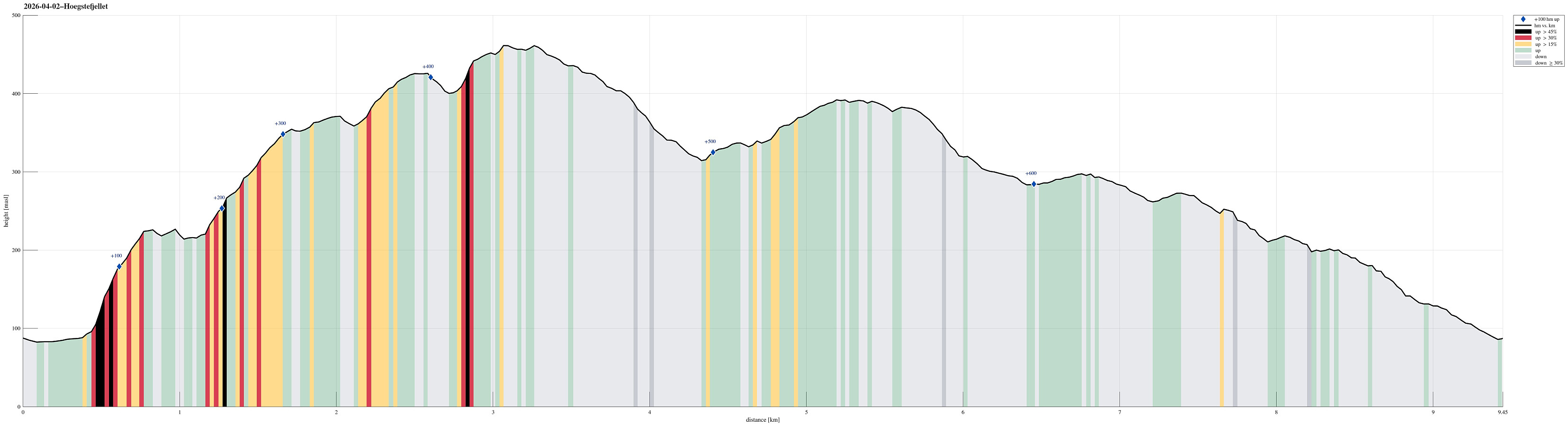
| Distance | 9.4km |
| Vertical meters | 679m |
| GPS |
|
| Ascents | Huseberget (230m) | 02.04.2026 |
|---|---|---|
| Høgstefjellet (464m) | 02.04.2026 | |
| Midtfjellet i Åsane (430m) | 02.04.2026 | |
| Visits of other PBEs | Tellevikafjellet søyle (390m) | 02.04.2026 |
Trip Summary
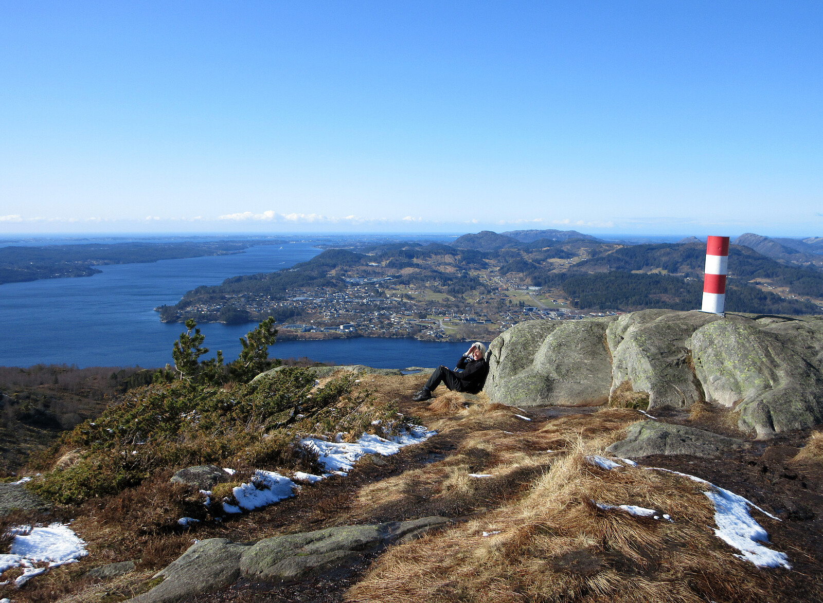
We expected a nice day and wished to make a nice hike without getting into too deep (wet) snow. The round around Baugtveitstemma, including Høgstefjellet and Tellevikafjellet, seemed just right. We found a place to leave the car behind near Salhusvegen, where one turns to towards Hitland and Baugtveit (further up the road). The original plan was to head eastwards, first, to get to a trail, which leads up to Huseberget from Salhusvegen. One from Hitland, however, was determined to avoid us going there (because of some sheep on the eastern side of Hitland). This required making up a plan B, which then basically was to ascend to Huseberget from the west (instead of from the south). Without having prepared this carefully at home, first, however, and knowing (and seeing) how steep Huseberget is on its western side, we were not really sure, where and how this would work out. After first stepping up (already moderately steeply) through the forest in northeastern direction, we then continued right underneath the cliffs (then in northern direction) further upwards. At about 150masl, however, we found a "diagonal" that looked doable. With some necessary extra-care -- after all, the terrain was also still very wet and not fully stable everywhere -- we made some additional height meters "up the cliff" (now southwards), before connecting to another "diagonal" (again northwards), which brought us then nicely to the heights above the cliff. Continuing further upwards to Huseberget was then straight-forward (albeit without any trail). From Huseberget, we then enjoyed a very nice view across Hitland! After then also crossing over the second hill-top of Huseberget, we stepped onto the trail, which comes up from Furbudalen. For a moment, we contemplated our choice of either following this trail or to continue off-trail in order to connect to "the high ridge" from Baugtveit up to Baugtveitgotene. It did not take us long to jointly decide for the latter. The continuation towards this ridge was first very pleasant. At about 260masl, we then met the steep southwestern slopes of the ridge. Also there, however, we quickly found a proper "diagonal" (in northern direction), which brought us up to the ridge without any difficulties. Just the last meters around the ridge required a bit of care. Once on "the other side" of the ridge (the northern side), the continuation further upwards was straight-forward, again (there's not really a trail on this ridge, but either two- or at least four-legged creatures have used this ridge so that one occasionally get an idea of a trail). Towards Baugtveitgotene, the ridge "flattens out", offering some very nice views (mostly towards the west and south). Once over the "top" of this ridge, we then (re-)connected with the trail that leads up to Midtfjellet. While this trail does not lead towards the very top of Midtfjellet, we still included this height (off-trail). When (again) re-connecting with the trail, in the northeast of Midtfjellet, one needs to check a little, where it's possible to cross over the little cut between Midtfjellet and Høgstefjellet. Once on the trail, again, the continuation up to Høgstefjellet is straight-forward, of course. On Høgstefjellet, we then enjoyed the nice views, but did not stay long, given the quite chilly wind from the north. Instead, we followed the trail further to get to the saddle in the northeast of Baugtveitstemma between Høgstefjellet (in the south) and Tellevikafjellet (in the north). On the other side, it then did not take long, before we arrived on the top of Tellevikafjellet (yet again offering very nice views). Next was to walk down to the saddle between Tellevikafjellet in the northeast and Nordgardsfjellet in the southwest. There, we again needed a decision: walk around Nordgardsfjellet along a trail, which we had not yet explored in its full length before, or above the top of it. Enjoying the idea to see something new, we decided for the former and walked around Nordgardsfjellet. After first hiking around Britafjellet, north of Nordgardsfjellet, we passed by Store Jørgenstemma (quite a nice little lake). Only a few steps further westwards, we then arrived at Åreina, where one can admire a massive, old dam, which previously held back quite a bit of water in Steindalen. The continuation of our hike was then along a longer arc over the heights above Salhusberget and Hattendalen towards a connection to Kistebakkane. While circling around Nordgardsfjellet along this trail, we really enjoyed some very nice views over Salhusfjorden, Herdlefjorden, and Byfjorden. Before actually getting all the way down to Kistebakkane, we then passed by an impressive stone wall. Following this diagonal connection further down in southeastern direction, we then stepped onto Hitlandsbakkane at Træet. From there, it was then only a few more meters down along the road. Back to the start point, we found ourselves very satisfied with the nice day and the interesting hike!
Photos
Selected photos are available as Google photo album.
Useful Resources
See also the related FB-page Hiking around Bergen, Norway.
On web page prominent-mountains.no, there's a useful page about Høgstefjellet, and also web page WestCoastPeaks.com provides useful information about Håstefjellet (Høgstefjellet), Tellevikafjellet, and Nordgardsfjellet.


User comments