
Morvikavarden, Olderhaug, and Geitanuken (01.03.2026)

Written by HHauser (Helwig Hauser)

| Start point | Myrdalsvegen (90m) |
|---|---|
| Endpoint | Myrdalsvegen (90m) |
| Characteristic | Hike |
| Duration | 3h 00min |
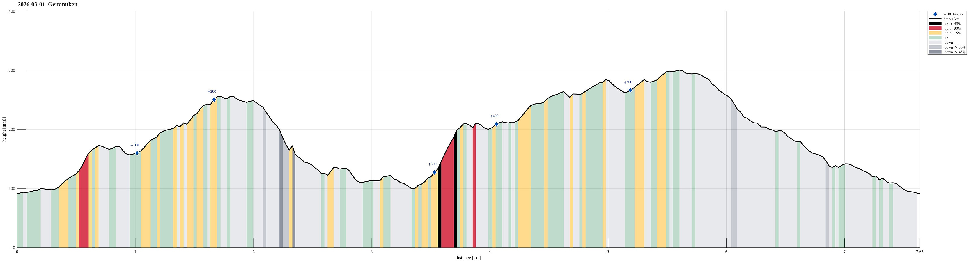
| Distance | 7.6km |
| Vertical meters | 578m |
| GPS |
|
| Ascents | Geitanuken (304m) | 01.03.2026 |
|---|---|---|
| Novvarden (267m) | 01.03.2026 | |
| Olderhaug (212m) | 01.03.2026 | |
| Stornipa (174m) | 01.03.2026 | |
| Visits of other PBEs | Morvikavarden utsiktspunkt (252m) | 01.03.2026 |
| Svenskenipa (265m) | 01.03.2026 |
Trip Summary
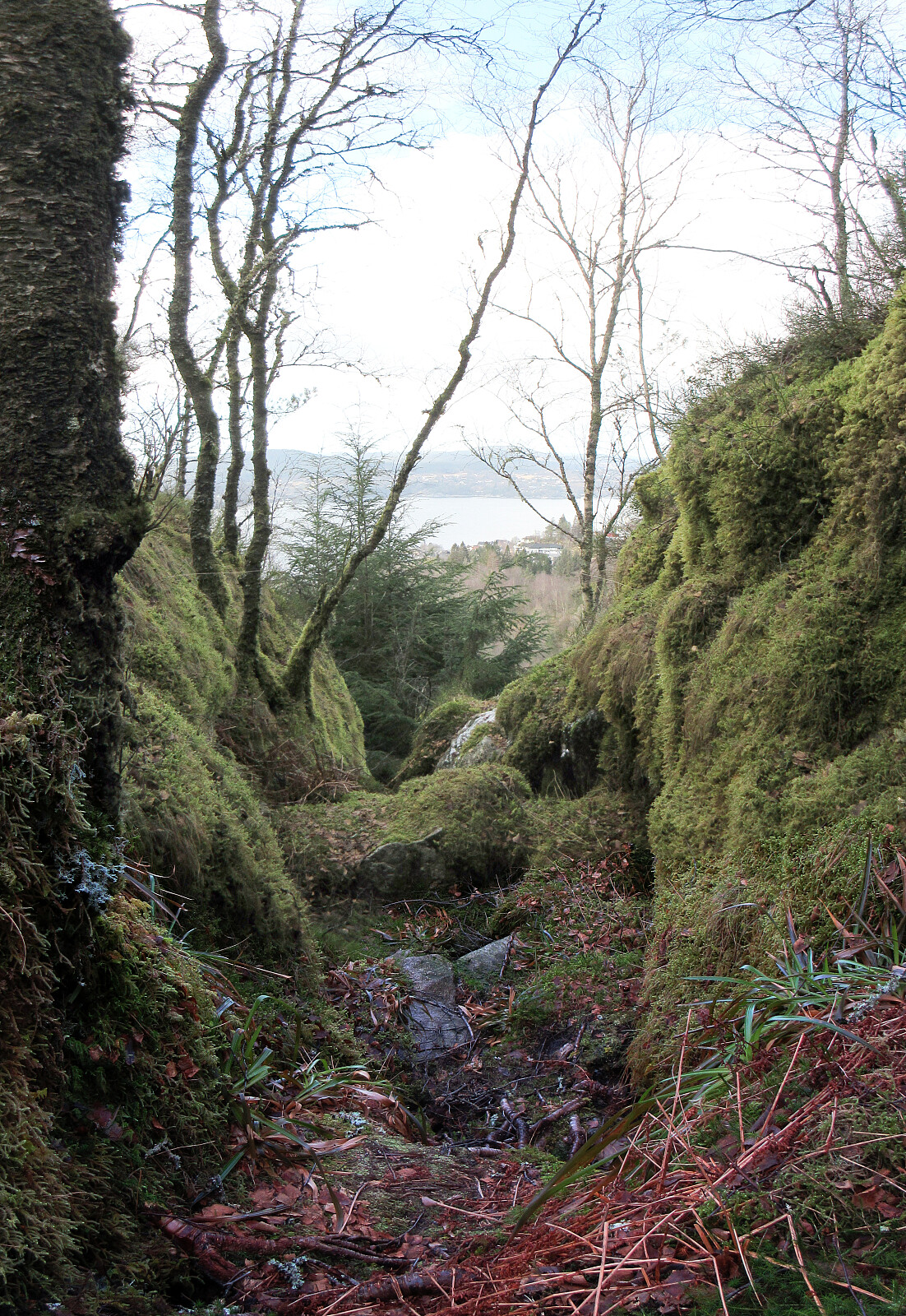
With also this Sunday inviting us to get some fresh air, we decided to visit Geitanuken again, while making it a round (an elongated one) from/to Åsane. We parked right next to Myrdalsvegen, not far from Åsane Arena, and then headed into the direction of Stornipa, first. In the northwest of Åsane Arena, we then also found a way to get over and into the forest. Stepping up to Stornipa was then just a question of a few minutes and the forest is actually quite nice there. Next, we wished to explore Morvikavarden and to get there, we crossed over Stornipa to connect with road Myrdalskogen in the north. On the northwestern side of "the big bend" of Myrdalskogen, we found an opportunity to "short-cut" further upwards through the forest. After yet again walking along Myrdalskogen for a short stretch (right underneath Riveskaftet), we then found the trail up the eastern ridge of Morvikavarden and from a point slightly south of its highest point, we then enjoyed some really nice views (mostly southwards). The next goal was to find a way down to Morviklien (further in the west) and at least first we even found a minor trail leading into this direction from Morvikavarden. One could argue even that this trail leads all the way down, but more correct is that it gets very unclear "half way down" and one needs to tread carefully in the rather steep terrain at Hestehjellane. In particular between about 200masl and 175masl, there's a need to circumvent some cliffs, also (it's fully doable, but some care is advised -- in one place, one even mounted a rope to assist). Continuing further down (westwards right underneath Hovdane) is then quite nice as the forest there appears almost mystical and "lost in time", somehow. We then found (without difficulties) the place, where we crossed the stream (again) in order to cross over to the northern side of Svehaugen (and to Morviklien there). Looking up the significant southern cliffs of Storfjellet is also impressive. A bit further westwards on Morviklien (and into Kolbudalen), we found the trail head for Olderhaug. This trail (via Toppegotene) up to Olderhaug is quite steep, but straight-forward to use (nice trail!). From Olderhaug, one can enjoy some really nice views in almost all directions! From there, the plan was then to simply cross over the heights to Geitanuken, but with one detail: pay Svenskenipa a visit, also. And so it was: we found that someone had cut out a new (simple) trail down to Svenskenipa from Jubileumsstien up on the ridge, which clearly eased this excursion (otherwise, some medium bush would be needed). The views from Svenskenipa are actually very nice! After then walking across Geitanuken, the goal was to simply hike back down to our car. Originally, we thought to do so via Riveskaftet, but we somehow followed the main trail down (further southwards to connect to Myrdalskogen) before understanding that we had taken the wrong turn. Not really wishing to go back up again, we just followed the route down which already had used up. From "the big bend" of Myrdalskogen, however, we followed a trail northwards to Skansen, from where we then walked down the road Myrdalsvegen. All in all, this was a very nice hike (and a bit more adventurous than originally anticipated -- mostly, because of the westward descent from Morvikavarden).
Photos
Selected photos are available as Google photo album.
Useful Resources
See also the related FB-page Hiking around Bergen, Norway.


User comments