
Kanadaskogen in new snow (23.11.2024)

Written by HHauser (Helwig Hauser)

| Start point | Varden (45m) |
|---|---|
| Endpoint | Varden (45m) |
| Characteristic | Hike |
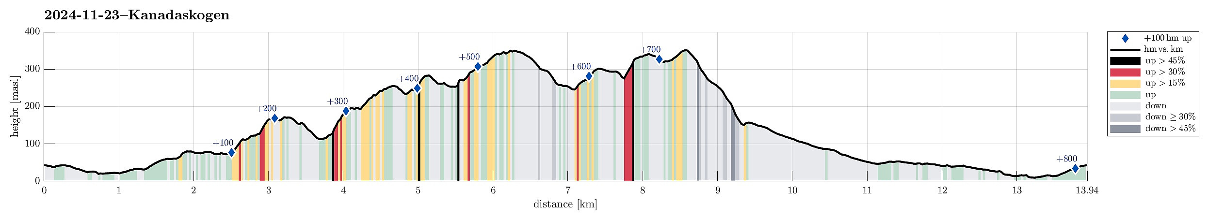
| Duration | 5h 00min |
| Distance | 13.9km |
| Vertical meters | 808m |
| GPS |
|
| Ascents | Damsgårdsfjellet (344m) | 23.11.2024 |
|---|---|---|
| Eikelifjellet i Bergen (258m) | 23.11.2024 | |
| Gravdalsfjellet (353m) | 23.11.2024 | |
| Olsokfjellet (353m) | 23.11.2024 | |
| Storhovden (174m) | 23.11.2024 | |
| Vest for Fyllingsnipa (286m) | 23.11.2024 | |
| Visits of other PBEs | Eikelisteinen (250m) | 23.11.2024 |
| Holefjellet utsikt vest (303m) | 23.11.2024 | |
| Les Smith Minnesmerke (90m) | 23.11.2024 | |
| Storhovden utsiktspunkt (172m) | 23.11.2024 | |
| Viggohytten (305m) | 23.11.2024 |
Trip Summary
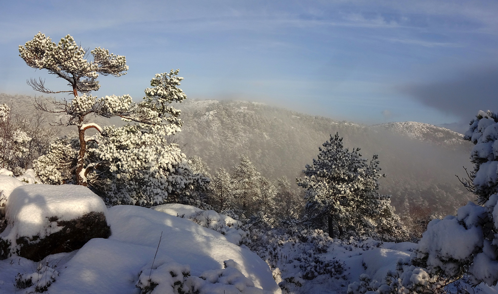
We looked forward to a quite nice day with some new snow. Instead of choosing a trip far from home, we decided to simply head into Kanadaskogen and see where it would take us. We first headed north from Varden and entered Kanadaskogen from Hesjakollen in the southeast of Litla Krokatjørna. We followed a simple trail further northwards, which brought us to the southwestern side of Stora Krokatjørna. With some low-standing sun casting light across the snow-covered landscape, we already enjoyed our excursion substantially! :-) From Stora Krokatjørna, we aimed at Storhovden as our next goal, stepping up the southern ridge of Syningen to get there. We then explored the three heights of Storhovden before continuing in northeastern direction. While first going off-trail, we eventually joined the trail that leads up to Storhovden from Langedalen, i.e., the connection between Spelhaugen and Tennebekktjørna. We did not stay in Langedalen for any mentionable time, though, heading out of it in eastern direction, instead, on a trail that leads up to Eikelifjellet. About half way up to Eikelifjellet, at about 200 masl, we made a short detour to explore a minor height there and to see whether it would offer any nice views, for example, towards Lyderhorn, or down to Tennebekktjørna. In principle, this clearly would be the case, but due to trees "everywhere", the actual views are basically all partially blocked. Further up to Eikelifjellet, however, at about 225 masl, a spot with great views is easily reached from the trail. Visiting Eikelisteinen then was very nice -- as always -- and we enjoyed the almost dramatic scenery with some sun from one side and some dark snow clouds on another. From Eikelifjellet, we then continued further northwards with the goal to visit Viggohytten. Following a nice trail, we stepped up to the heights in the south of Nipetjørna. Briefly, we considered to hike first up to Gravdalsfjellet via the dam in the northwest of Nipetjørna before then stepping down to Viggohytten. We decided against this option, however, given the many icy spots under the snow and the rather steep way up to Gravdalsfjellet on this side. Instead, we followed the trail into the east of Nipetjørna and then taking the "main trail" up to Viggohytten from the saddle near Brattheim. After enjoying a short break at Viggohytten, we the stepped up to Gravdalsfjellet through pristine snow. At Gravdalsfjellet, we then decided to also include Holefjellet, Damsgårdsfjellet, and Olsokfjellet. Following the "main trail" on the heights around Nordnesdalen, we reached Olsokfjellet not so long later. The ascent from Skaret to Damsgårdsfjellet turned out less tricky than first thought (because of all the ice under the snow). From Olsokfjellet, we then descended along its southern ridge (towards Litlafjellet). After making it down to about 260 masl, we came to the spot, where two options for continuing on a trail are given: to the west and down into Nordnesdalen, or to the east and down to Tjønnen. Since we could not remember ever having taken the latter, we decided to try this route, this time. Even though steep in a few places, we still made it down to Tjønnen with out any difficulties. After crossing over a minor saddle in southward direction, we connected to Øvre Fyllingsveien, which we then walked further down into Fyllingsdalen. Nice days with new snow are clearly not that usual around here, so making such an extended walk through the winter landscape was very enjoyable! :-)
Photos
Selected photos are available as Google photo album.
Useful Resources
See also the related FB-page Hiking around Bergen, Norway.


User comments