
Storenuvarden and more (19.10.2024)

Written by HHauser (Helwig Hauser)

| Start point | Varden (45m) |
|---|---|
| Endpoint | Varden (45m) |
| Characteristic | Bike trip - mixed |
| Duration | 6h 30min |
| Distance | 70.6km |
| Vertical meters | 1,889m |
| GPS |
|
| Ascents | Gaukavarden (236m) | 19.10.2024 |
|---|---|---|
| Haukheia (180m) | 19.10.2024 | |
| Hinderåsen (229m) | 19.10.2024 | |
| Leitåsen (206m) | 19.10.2024 | |
| Litlenuvarden (172m) | 19.10.2024 | |
| Nedstaheia (164m) | 19.10.2024 | |
| Storenuvarden (212m) | 19.10.2024 | |
| Visits of other PBEs | Bergen stasjon (4m) | 19.10.2024 |
| Bryggen i Bergen (1m) | 19.10.2024 | |
| Fyllingsdalstunnelen - Kristianborgsiden (18m) | 19.10.2024 | |
| Fyllingsdalstunnelen - Oasensiden (34m) | 19.10.2024 | |
| Grytebakkbrua (180m) | 19.10.2024 | |
| Kvamsvegen p-plass (190m) | 19.10.2024 | |
| Kvernafossen (100m) | 19.10.2024 | |
| Sælen kirke p-plass (15m) | 19.10.2024 |

Trip Summary
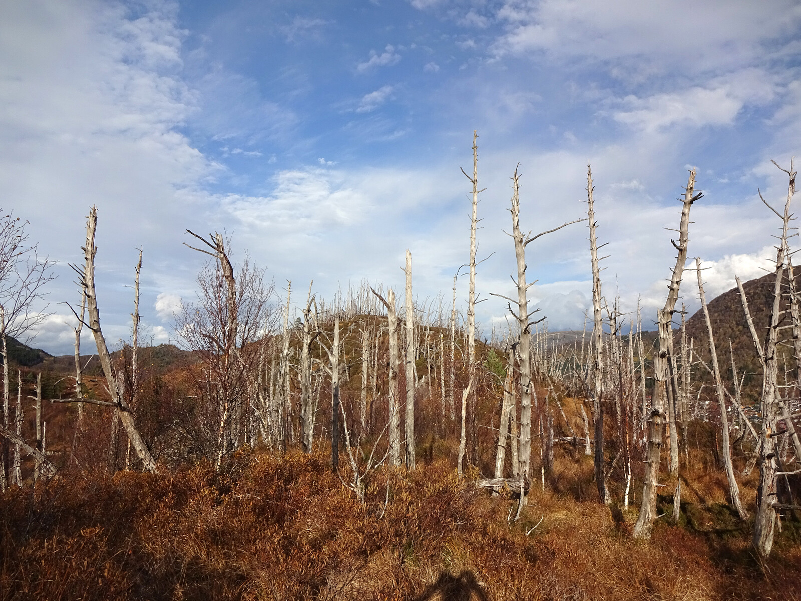
Given the nice autumn weather, I made a plan to cycle around Vidden and explore some minor hills along the way. I started by cycling around Nordåsvatnet (in its north), continuing to Paradis. From there, I took the road through Sanddalen to get to the main axis towards Arna from Nesttun. It started in Sanddalen that I understood that this trip will be special, given a chain that had become quite slippery, already -- the relatively steep part upwards on Sandbrekkevegen I already had to push the bike... My first exploration goal of the day was to bike out Hardangervegen right next to the train tracks on the other, southeastern side of Midtunelva. This works, but the path (or better "path") is not really prepared and biking there with a street bike, for example, is not reasonable. I continued on the southeastern side of Midtunelva all the way to Helldalen, where I crossed it (to connect to road Helldalsneset) in the north of Nausthaugen, only a few meters from where the stream comes out of Grimevatnet. To get past Helldalsåsen, I then had to get up and across Hardangervegen. Down, again, in the northeast of Grimen, I then departed from the cycling route and started cycling up Erdalsvegen, instead. I knew that this would bring me up the old former postal route to Christiania (in upper Erdalen), which -- as I had seen before -- is not suited for cycling, but since I had liked that connection, especially also because of its historic context, I had made my plan to still continue my trip this way. At house #101 at about 115 masl, the paved road ends and the former postal route to Christiania continues straight. That was then also the point for unmounting the bike, again, and start pushing it further upwards. Once over the saddle at about 180 masl, a rather steep descent follows into the direction of Brattland. At about 120 masl, a choice has to be made between continuing further down (to Nedre Brattland) and "up and across" (to Øvre Brattland). Via the upper route, I then got to Øvre Brattland (and Brattlandsvegen there at about 135 masl). Originally, I had hoped that I would be able to continue cycling from there, but after only a few meters, half way to house #158 at Øvre Brattland, I had to get off the bike, again, and continue pushing. The steep road Brattlandsvegen brought me then up to a high point (at about 195 masl) in the west of Gaukavarden. At this point, you even find a table with benches for a possible rest. My goal, however, was to explore the hill Gaukavarden (and then Hinderåsen, also). I thus left my bike near the resting place, and found a way up the rather steep western side of Gaukavarden. With the help of my hands, this was not really difficult and within minutes, I had made it up to the heights of Gaukavarden. After first exploring the southern heights of Gaukavarden a little, I then headed north (and over the "top" of Gaukavarden) to a nice place, where someone has put up a shelter with an amazing view towards the east (across Haukeland and towards Gullfjellet etc.). Next was to cross over to Hinderåsen. I descended from Gaukavarden, following the simple access "trail" (to the shelter), first. At the first saddle in the northwest of Gaukavarden, I then took a more direct route towards Hinderåsen (this descent in northeasern direction was not really difficult -- still, I'd now recommend to "walk around", instead). On the other side, it was then quick to get onto the southern slopes of Hinderåsen (with some high-standing forest there). Stepping up to the "top" of Hinderåsen was then nice and straight-forward. The "top" of Hinderåsen is then non-exciting, but one still get some nice views from up there. Having checked out Hinderåsen, it was to get back to the bike. I first continued a bit further northwards in order to find a good way down the rather steep western flank of Hinderåsen. Once that was found, I headed back for the northern ridge of Gaukavarden, again. Getting there involved my first happy moment of one soaked shoe. Eventually, I basically made it back to this saddle, where I had ventured off on my "detour" to Hinderåsen before, just to take the other turn, this time, down a small valley in the northwest of Gaukavarden. When studying the map back home before leaving, I did look at this valley, but did not think much about it -- eventually, it turned out a tiny bit more complicated than expected (due to fallen trees, big rocks, water, holes between the rocks, etc.). This "short cut" is not really one that I would recommend, after all. Back on my bike, I wanted to follow Brattlandsvegen (over Borgarinden) to get into Langedalen. This worked well, given some very careful biking down the rather steep gravel road. Once in Langedalen, the next exploration goal was Leiteåsen. I left my bike at the main road through Langedalen (note that this "main road" still is 1 to 1.5 lanes wide!) and first walked towards Leitet. Using two gates, I found a good route to get behind the houses and onto the ascent to the "top" of Leiteåsen. While this ascent was very nice and enjoyable, the "top" of Leiteåsen is not so amazing. Still, it at least offered a very nice view over to Borga in the north! On my way back to my bike, I decided to follow a route that would take me alongside Borgaelva for some steps. Back on my bike, I continued further upwards through Langedalen. After passing Tangelandsvatnet, I wished to explore the area north of Dalselvi a little. Near Rødland, I again left my bike behind at the "main road", and started walking into southeastern direction alongside Dalselvi. Near Kvernavadet, I then used a hiking trail (still parallel to Dalselvi) to check out Kvernafossen. From there, I then started my hill-walk towards the north, crossing first over some apparently unnamed hills until I got to Nedstaheia in the east of Krokavatnet. At a few points, I could enjoy some nice views, both towards east and to the west. From Nedstaheia, I then wished to cross over to Haukheia (in the north of Krokavatnet). To do so, I needed to find a reasonable route down from Nedstaheia, first. Even though the western flank of Nedstaheia is quick steep, I still found a quite reasonable route down. Crossing through the valley between Nedstaheia and Haukheia replenished the by then almost dried up water in my shoes (filling one of them up to the rim -- yeah!). Ascending to Haukheia from the southeast was then fine (but rather steep). The first high point on Haukheia, a bit further south of the actual "top", offered a very nice view, in particular across Krokavatnet in the south. Crossing over Haukheia then turned into an almost surreal experience -- most likely due to some serious forest fire all trees had died while they kept standing there, dried and turning kind of silver in color. After Haukheia, the next exploration goal was Storenuvarden. To get there, I had to cross Kvernaskaret, which involved a short stretch of steep descent from Haukheia (all fine, but some careful stepping required). From Kvernaskaret, I then could use a trail -- how nice! :-) -- up to Storenuvarden. From Storenuvarden, one can enjoy some very nice views across Arna. To complete the exploration of this area, I then headed towards Litlenuvarden. The north of Storenuvarden has some very steep parts (even some cliffs), but carefully following the trail lead me down to the heights between Storenuvarden (in the south) and Litlenuvarden (in the north) without any problems. Walking over to Litlenuvarden was then straight-forward and nice. To then get back to my bike, again, I needed a plan that would help me around the rather large construction area in the east of Litlenuvarden and Storenuvarden. I followed a trail down from Litlenuvarden (to the west) and crossed over to the other, western side on a dam (with a road on top). On the other side, I then ascended to the height of Mossheia (right in parallel of the high fence there) -- this ascent is significantly steep and the terrain is partially loose, so some careful stepping is required to take this direct route up there. From Mossheia, I then walked in southern direction, following the "high line". Near house #463, I got back onto a paved road and walking this one "out", I soon was back on the "main road" through Langedalen. Since I already experienced some exhaustion, I started to focus on completing my round. Even though it still seemed to be somewhat longer option, I was still committed to competing my round around Vidden and cycle home via Åsane. I thus cycled further northwards (first to Haugland, and then further to Blindheim, in parallel to E16). Basically at Vågsbotn, in the southeast of Langavatnet, I then joined the biking route to Bergen. This brought me first into the vicinity of Åsane Senter, before continuing further southwards over Stamskaret. At Eidsvåg, I could have chosen to cross over Munkebotn, but decided to instead continue along the main biking route to Bergen, including the "detour" around Eidsvågsneset. Given that this is one of the most prominent biking routes in the area of Bergen -- I think that it even has the number 1 as such! -- it is remarkable that there is no place (and no respect by some drivers) for bikers at quite many places along this route around Eidsvågsneset. With luckily only one near-accident I made it further south to Bergen. Already near Åsane, I started to question whether my eBike would continue its service to me until I'd be home -- even though I was operating it at the lowest possible output level, already, it did not look promising! Once through Bergen, my worries intensified as the predicted distance of remaining operation consistently showed too little for getting me home. The thing is that an off eBike is much worse than a regular bike -- at least mine -- and that I already was feeling the strain on my legs after the rather long excursion. I made it through the tunnel to Fyllingsdalen, when the bike eventually gave up. I still managed to bike down to Varden, where I -- for the last time of this day -- unmounted the bike to push it back home. In a way, an end to this trip that mirrored one repeating characteristic of the entire trip! :-) After eventually arriving back home, I clearly was ready for showering and something to drink and eat! :-)
Photos
Selected photos are available as Google photo album.
Useful Resources
See also the related FB-page Hiking around Bergen, Norway.


User comments