
Bike-hiking Landåsfjellet and more (01.09.2024)

Skrevet av HHauser (Helwig Hauser)

| Startsted | Varden (45moh) |
|---|---|
| Sluttsted | Varden (45moh) |
| Turtype | Blandet sykling |
| Turlengde | 4t 00min |
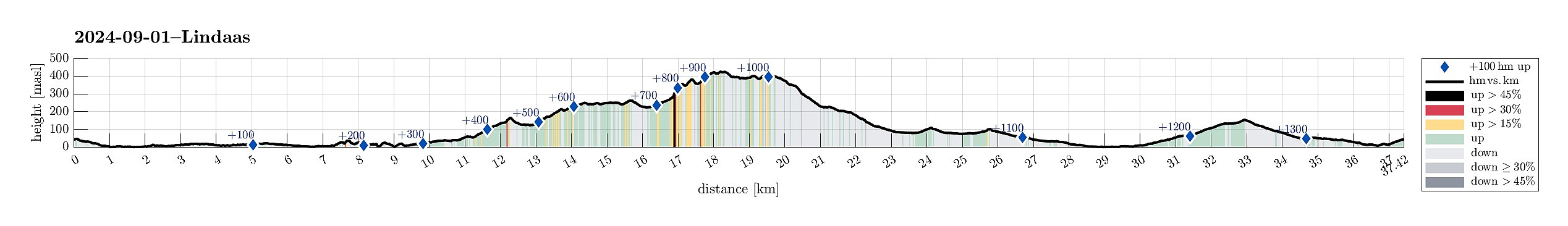
| Distanse | 37,5km |
| Høydemeter | 1363m |
| GPS |
|
| Bestigninger | Gamlehaugen (43moh) | 01.09.2024 |
|---|---|---|
| Kronhaugen (386moh) | 01.09.2024 | |
| Landåsfjellet (428moh) | 01.09.2024 | |
| Landåsfjellet trigpunkt (427moh) | 01.09.2024 | |
| Langhaugen (102moh) | 01.09.2024 | |
| Nattlandsfjellet (252moh) | 01.09.2024 | |
| Nonskletten (113moh) | 01.09.2024 | |
| Orrehaugane (415moh) | 01.09.2024 | |
| Ramsdalsstrupen (265moh) | 01.09.2024 | |
| Stulihaugen (362moh) | 01.09.2024 | |
| Andre besøkte PBE'er | Baunehytten (390moh) | 01.09.2024 |
| Bryterhytten (tuft) (399moh) | 01.09.2024 | |
| Fjellro (tuft) (387moh) | 01.09.2024 | |
| Nattlandsfjellet trig.punkt (246moh) | 01.09.2024 | |
| Nordre Nattlandsfjellet p-plass (230moh) | 01.09.2024 | |
| Norheim (tuft) (340moh) | 01.09.2024 | |
| Sælen kirke p-plass (15moh) | 01.09.2024 |
Trip Summary
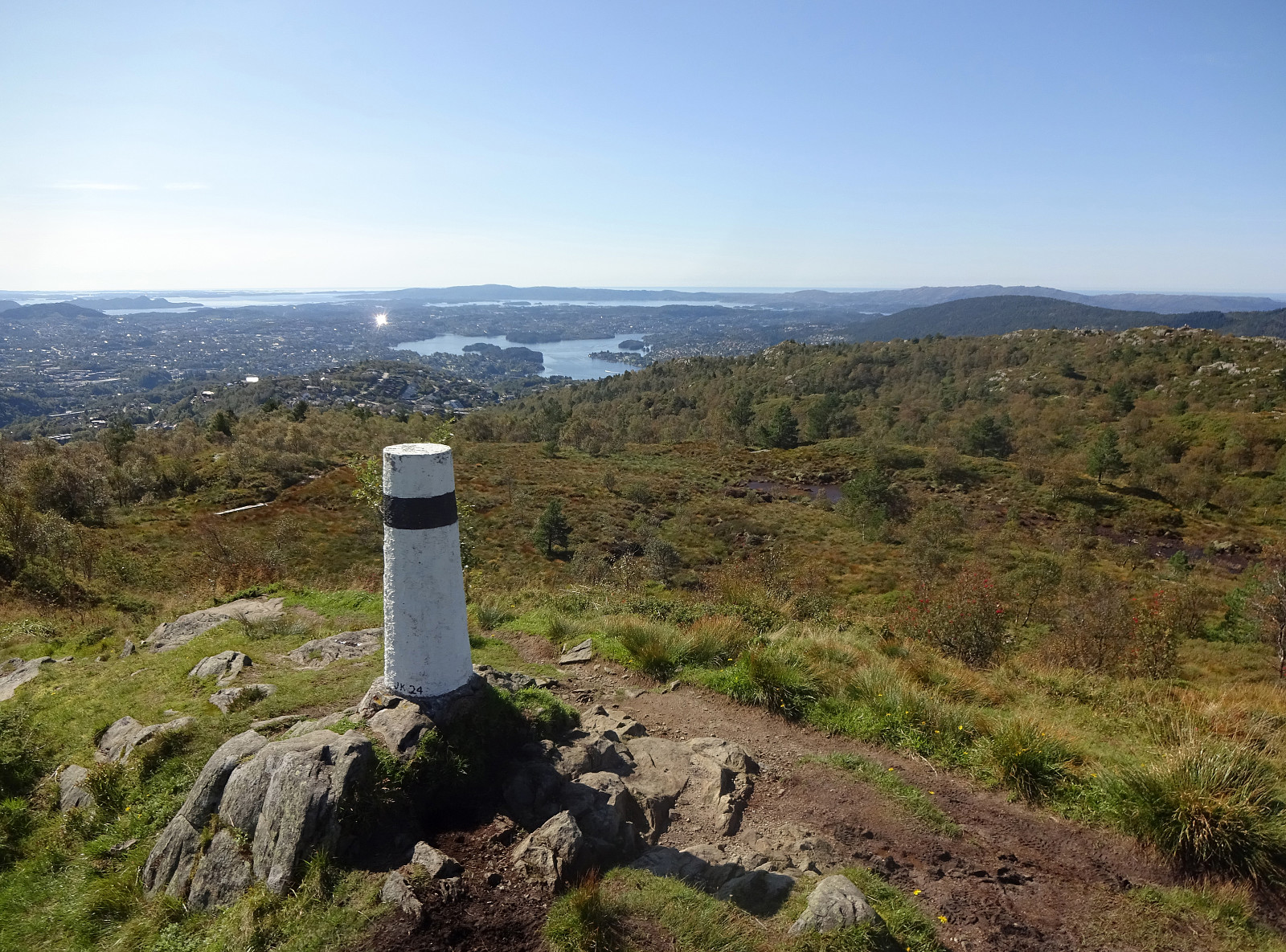
Somehow, I thought that this Sunday was the day for visiting Nattlandsfjellet and checking out the view-point right above the tunnel of Nye Sædalsveien. I got onto my eBike and biked around the south of Bønes, following the north shore of Nordåsvatnet. This brought me to Gamlehaugen, where I decided to interrupt my bike-trip for a short exploration of the area around the King's house. My first goal there was to get up to the small hill in the southeast of the mansion. I first thought that there would be a way to get there "directly", just to find that this little hill has some rather steep cliff on its west-side -- not high, but high enough to be an obstacle. Walking around, however, brought me to a path that -- while apparently not much used -- lead me easily and conveniently up to the "top". I then tried to find my way (without any path or trail) to the south-end of this small hill -- it's possible, but maybe not a recommended way of descening. I then proceeded further southwards to check out whether there was a way to get up to Olderhaugen on the west-side of the highway. While it's fully possible to get up to the small hill in-between Gamlehaugen and Olderhaugen, it's not possible (not without actual climbing) to get also up to Olderhaugen from the north. I thus turned around and walked back to my bike, taking a slightly more western route to also see the bathing-spot in the west of Gamlehaugen. Back on my bike, I passed by Paradis to connect to Birkelundsbakken. Once up there, I turned right and surrounded Nattlandsfjellet in its south first, before then finding my way up to Nattlandsfjellet from the southeast (Sædalsvegen). Once on Nattlandsfjellet, I made a quick round to see the view-point and indeed one can enjoy a nice panoramic view over Bergen from up there. My next goal was Landåsfjellet and I had thought to get there via some smaller hills that I had not visited before: Stulihaugen and Kronhaugen. On my way to Ramsdalen, I included a short visit to Ramsdalsstrupen -- not much to see up there, I'd say. I then left by bike behind at the parking area in the south of Ramsdalen and continued per pedes towards Landåsfjellet. Right before the gravel road through Ramsdalen meets the road that comes up from Helgeseter, I turned left and onto a trail that promised to lead up to Stulihaugen (no sign, though). Indeed, this proved to be right and I followed this nice trail upwards until I was close to Stulihaugen. The last meters to the "top" of Stulihaugen, I then did off-trail, overcoming some dense vegetation there. There's nothing special about this hill that makes me think that I will head there soon again. To get over to Kronhaugen, I then descended to the road that comes up from Helgeseter, followed it for a short stretch, carefully avoiding any collision with the many others, who traversed this road up and down -- yes, this really was a nice Sunday after an August with a new rain-record. Once in the west of Kronhaugen, I hopped over the little stream in the east of the road and ascended to the "top" of Kronhaugen off-trail (but without any difficulties). Next, my plan was to descend off-trail from Kronhaugen towards the east/southeast in order to connect with a trail that then was supposed to bring me up to Landåsfjellet from the south. Finding my way down from Kronhaugen was OK, but not ideal (there's quite some vegetation, which contributed to me choosing to follow a little stream, which, in turn, contributed to my shoes getting more wet than what I originally had hoped for). Once on the trail, proceeding to Landåsfjellet was "straight-forward" (even though the trail is in parts very muddy and wet, also). On Landåsfjellet, I also included a short visit to the little hill in its east, before starting my hike back to my bike. I descended from Landåsfjellet towards the north, walking around Nubbevatnet to get to its western side. I then found my way to Orrehaugane and further to the long southwestern ridge (down to Sveane) that brought me back to my bike very nicely. After biking down from Nattlandsfjellet -- make sure that your brakes are good! :-) -- I included a short visit to Nonskletten and Langhaugen, before I "ended up" in Solheimsviken. There I certainly was not the only one, who enjoyed some afternoon sun! Back home it was then via Melkeplassen.
Photos
Selected photos are available as Google photo album.
Useful Resources
See also the related FB-page Hiking around Bergen, Norway.


Kommentarer
Hike-a-bike :)
Skrevet av hbar 03.09.2024 21:17A tip for your next bike-hiking trip, bring the bike with you on the hike: https://restrap.com/products/hike-a-bike-harness?country=NO
Maybe not the best idea with a presumably heavy e-bike though..? ;)
Re: Hike-a-bike :)
Skrevet av HHauser 04.09.2024 08:57That's a funny idea and I see that some may consider it. Haven't seen many, though, who hiked their bikes up and down de syv fjellene, so far. :-) A bit of a stretch, maybe, anyway...
Re: Re: Hike-a-bike :)
Skrevet av hbar 04.09.2024 12:11Here's some inspiration: "Hike-A-Bike Bikepacking Route through Jotunheimen National Park" - https://www.youtube.com/watch?v=S1Fhq1tyO2o. :)