
Exploring Ytrebygda a little more (24.07.2024)

Geschrieben von HHauser (Helwig Hauser)

| Startpunkt | Varden (45m) |
|---|---|
| Endpunkt | Varden (45m) |
| Tourcharakter | Fahrradtour gemischt |
| Tourlänge | 2h 30min |
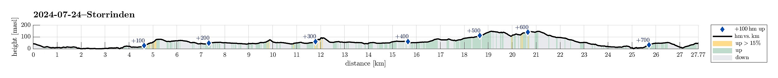
| Entfernung | 27,8km |
| Höhenmeter | 767m |
| GPS |
|
| Besteigungen | Lilandshaugen (95m) | 24.07.2024 |
|---|---|---|
| Storasåta på Liland (76m) | 24.07.2024 | |
| Storrinden (153m) | 24.07.2024 | |
| Storåsen på Søreide (87m) | 24.07.2024 | |
| Besuche anderer PBE | Storgrinden (148m) | 24.07.2024 |
| Storrinden demning (104m) | 24.07.2024 | |
| Storrinden utsiktspunkt (142m) | 24.07.2024 | |
| Straume bro (5m) | 24.07.2024 | |
| Sælen kirke p-plass (15m) | 24.07.2024 | |
| UFO-en Storrinden (120m) | 24.07.2024 |
Trip Summary
To get some fresh air in the nice weather, I embarked on a short bike trip with a few small walking bits. I first explored Storåsen on Dolvikhaugene, just to find the "actual top" to be a bit too much within the houses around it. I then visited Skranevatnet in the southwest of Feråsen, which was a nice surprise. Next, I explored Storasåta in the north of Ytrebygsvegen. When approached from the north/northeast, one can actually find a proper trail that leads up to this small hill. Thereafter, I paid Lilandshaugen a short visit, which offers quite some nice views across the airport of Bergen. I improvised my way up, just to then find out that actually there's a convenient road (Lilandsvegen) that leads up to the vista-point. After biking around Lilandshaugen, I then checked whether I could surround the "lightrail parking etc." at Kokstadflaten in its northwest, just to soon find out that this did not look promising with a bike (per pedes, however, should be possible). Following "standard roads", instead, I traversed Kokstad to get to my final exploration place during this excursion: Storrinden. While I had been on Storrinden a few times, already, I still wished to see a few places that I hadn't seen before: some vista-point in its south, the little lake in its west, the "UFO", and Tårnet on Dansehaugen. After leaving my bike behind, I thus made a short walking round around the heights of Storrinden, visiting these places. While stepping around on Storrinden is straight-forward, also without any trail, it can be wet here and there. On my way back, I chose to passing by Knappatjørna (instead of biking along Sælevatnet as usually).
Photos
Selected photos are available as Google photo album.
Useful Resources
See also the related FB-page Hiking around Bergen, Norway.


Benutzerkommentare