
Hiking to Jemo and Wochecha with a colleague of mine (02.06.2024)

Written by Solan (Atle Solholm)

| Start point | Burayu, Addis Abeba (2,466m) |
|---|---|
| Endpoint | Burayu, Addis Abeba (2,467m) |
| Characteristic | Hike |
| Duration | 6h 24min |
| Distance | 23.9km |
| Vertical meters | 1,666m |
| GPS |
|
| Ascents | Jemo (2,927m) | 02.06.2024 |
|---|---|---|
| Wochecha Mountain (3,391m) | 02.06.2024 |
![Image #1: The trail up the east ridge of mount Jemo [2927 m.a.m.s.l.].](https://images2.peakbook.org/images/14939/Solan_20240623_66774bec771a8.jpg?p=xtralarge)

We had been in Addis Ababa for slightly more than a week, my colleague and I, when we decided to have a hike to the summit of Wochecha; the high mountain just west of Addis Ababa. While in Addis, we had frequently been out jogging in the early morning, and that had helped us acclimatise slightly to the high altitude. The summit of Wochecha is, however located at 3391 m.a.m.s.l., while our whereabouts in Addis Ababa were mainly around 2400 m.a.m.s.l.; hence a hike to Wochecha still implied the gain of another 1000 vertical meters.
![Image #3: The summit of Mount Jemo [2927 m.a.m.s.l.] is coming into view.](https://images2.peakbook.org/images/14939/Solan_20240623_66774dbe921ef.jpg?p=xtralarge)
![Image #4: At the summit of Jemo mountain [2927 m.a.m.s.l.].](https://images2.peakbook.org/images/14939/Solan_20240623_66774e3a546c4.jpg?p=xtralarge)
As for myself, I had been to Addis Ababa multiple times, and this was my third ascent of Wochecha. The first time, I hiked all the way from our hotel in central Addis Ababa, to the western outskirts of the city, before embarking on the real ascent; and so the hike took almost 12 hours. The second time, I cached a cab that took me to the outskirts of the city, but once at the summit, I encircled the central valley of Wochecha along the surrounding rim (because Wochecha is an old volcano with the central valley being the remnant of the old crater); and so the complete hike took me almost 9 hours even then. For a detailed description of these two hikes, follow these links:
- 12 timers fottur fra Addis Ababa til Wochecha Mountain t/r (Tour description in Norwegian)
- Climbing Mount Wochecha and encircling the old crater (Tour description in English)
My colleageue was, however on only his second visit to Ethiopia, and had never been mountain hiking in the country; and so I offered to take him to the summit of Wochecha, in order that he could have an opportunity to see a little more than just the capital city while in Ethiopia.
![Image #5: Just at the summit of mountain Jemo [2927 m.a.m.s.l.] a volleyball field has been made.](https://images2.peakbook.org/images/14939/Solan_20240624_6679a7436f8ee.jpg?p=xtralarge)
![Imagee #6: Wochecha mountain [3391 m.a.m.s.l.] as seen from the summit og Jemo [2927 m.a.m.s.l.].](https://images2.peakbook.org/images/14939/Solan_20240624_6679a813c2ebf.jpg?p=xtralarge)
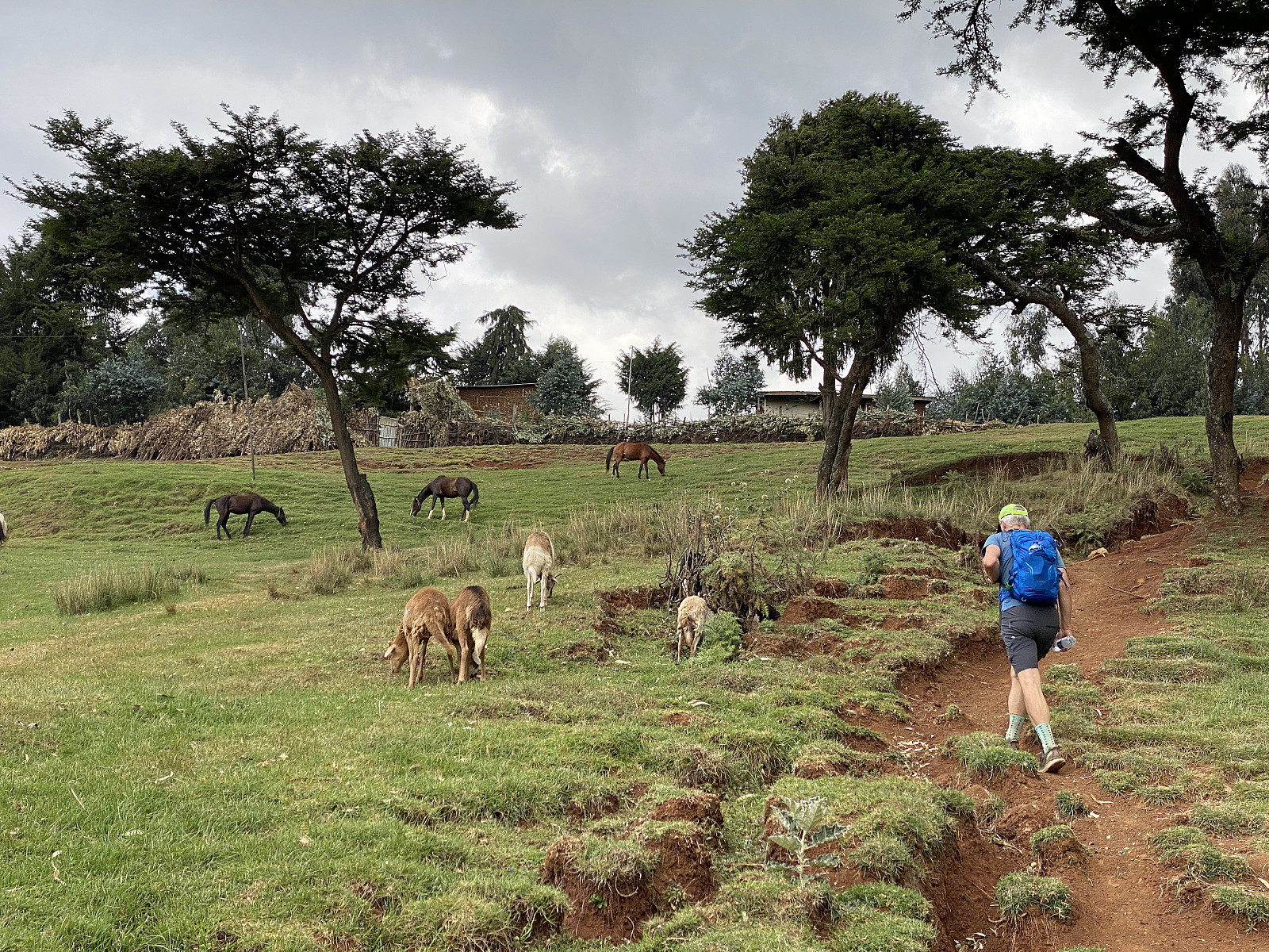
We took a taxi to the suburb called Burayu, and made an appointment with the taxi driver to pick us up again at the same location at 6 o'clock in the evening; and then we set off up the mountain side. The first two kilometers or so, was in a still somewhat urban area, but then we passed the city border of Addis Ababa, entering into the state of Oromia; and all of the sudden, the landscape became more rural (Image #1). We pushed rather quickly upwards, and only made a stop or two to capture some photos of the scenic view (images ## 2-3). We soon approached the mountain top of Jemo [2927 m.a.m.s.l.], a forepeak that you have to traverse before you embark upon Wochecha proper. I have on previous occasions just passed across Jemo about 300 meters north of the summit. This time, however, I had studied the map over this part of our trip more carefully in advance; and noted that there actually is an alternative trail that would take us up to the summit of Jemo. So shortly before the top of the mountain, we left the main trail, taking the alternative route to the left, and headed towards the summit (see GPS-tracking).


On the summit of Jemo we were a little bit surprised to find a little volley ball field (Images ## 5 & 6), or at least with the net across it, it certainly looked like a volley ball field; though it probably serves as a local football field as well. From the summit of Jemo we had to descend 158 vertical meters into the valley in front of us, before we could start climbing up one of the ridges leading up to the summit of Wochecha. We followed a trail that led us passed some small villages on our way down from Jemo. The trail eventually led us back to the main trail that we had been following (again, see GPS tracking). We soon reached the bottom of the valley, where we passed through a slightly larger village (Image #9), and then startet our climb up the mountain side of Wochecha.

We followed the same mountain ridge upwards as I've been following on both the previous occasions that I've climbed this mountain. The landscape up here was typically rural, with teff- and barley fields covering the mountain sides, and scattered small villages located along the mountain ridges. As we were about to pass by one of the villages, it started raining heavily. Luckily for us, there was a small roof above the entrance door in the fence that surrounded that particular village; and this little roof provided sufficient shelter for us for the twenty minutes that this heavy weather lasted. While we were standing there, it even started hailing heavily, with hails as large as a centimeter in diameter; so we were quite happy that we were actually standing beneath a roof, even if it was a rather small one.


As the rain stopped pouring down, we continued our hike upward. The trail was quite muddy and slippery at first, but it quickly dried up, and so hiking was back to normal. We followed the trail upwards past one village after the other, and finally we reached the top of this ridge on the north side of Wochecha. As we passed by the last village on the ridge, a number of youngsters came out and started following us; in part out of pure curiosity, as these villages aren't exactly frequently visited by two white guys, but in part also because they were hoping to get something from us.

![Image #14: Me on the summit of Wochecha [3391 m.a.m.s.l.] with Moglē Korebta [33244 m.a.m.s.l.] in the background.](https://images2.peakbook.org/images/14939/Solan_20240624_6679ad7aae4d2.jpg?p=xtralarge)
Where the mountain ridge ended, we turned right towards the summit of the mountain. A brief look at any map of this mountain (including the Peakbook map with our GPS tracking), reveals that we were now on the circular edge once upon a time surrounding the open crater of this ancient volcano. We followed this edge westwards till we arrived at the top plateau of the mountain, and then turned south again for another 100 meters, in order to reach the highest point of the mountain.


As we embarked on our descent from the mountain, our young companions started saying "give me dollar". None of them actually spoke any English, but they had somehow learned a few words, obviously. We replied "no dollar", and as they realised they weren't getting anything, they stopped following us one by one. We chose a different mountain ridge for our descent (see GPS tracking), but shortly before the village at the bottom of the valley, the two trails merged into one; and from there on we followed the same trail back to Addis Ababa as we had followed in the other direction, apart from the fact that we now skipped the summit of Jemo, as there wasn't any need for us to visit that summit a second time on the same day. We were back at the taxi at about 5 minutes past six, and a few minutes before our arrival, the driver actually called me on my mobile phone to check in on us, as he was worried about us in case we wouldn't be back down from the mountain before darkness. Back in the city centre we payed him quite well, not just for taking us to the outskirts of the city, but for even waiting for us for the entire day; as a trustworthy taxi driver is a very important connection to have in a city like Addis Ababa.


User comments