
Bergens lengste bakke, one of the classics near Bergen! (09.09.2023)

Written by HHauser (Helwig Hauser)

| Start point | P Hausdalen (95m) |
|---|---|
| Endpoint | P Hausdalen (95m) |
| Characteristic | Hike |
| Duration | 5h 15min |
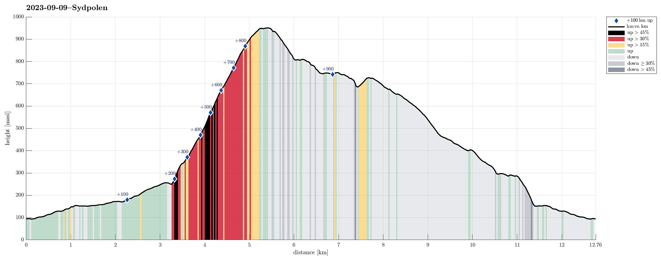
| Distance | 12.8km |
| Vertical meters | 991m |
| GPS |
|
| Ascents | Hausdalsgullbotntoppen (755m) | 09.09.2023 |
|---|---|---|
| Sydpolen (952m) | 09.09.2023 | |
| Toro (733m) | 09.09.2023 | |
| Visits of other PBEs | Hausdalen parkering (94m) | 09.09.2023 |
Trip Summary
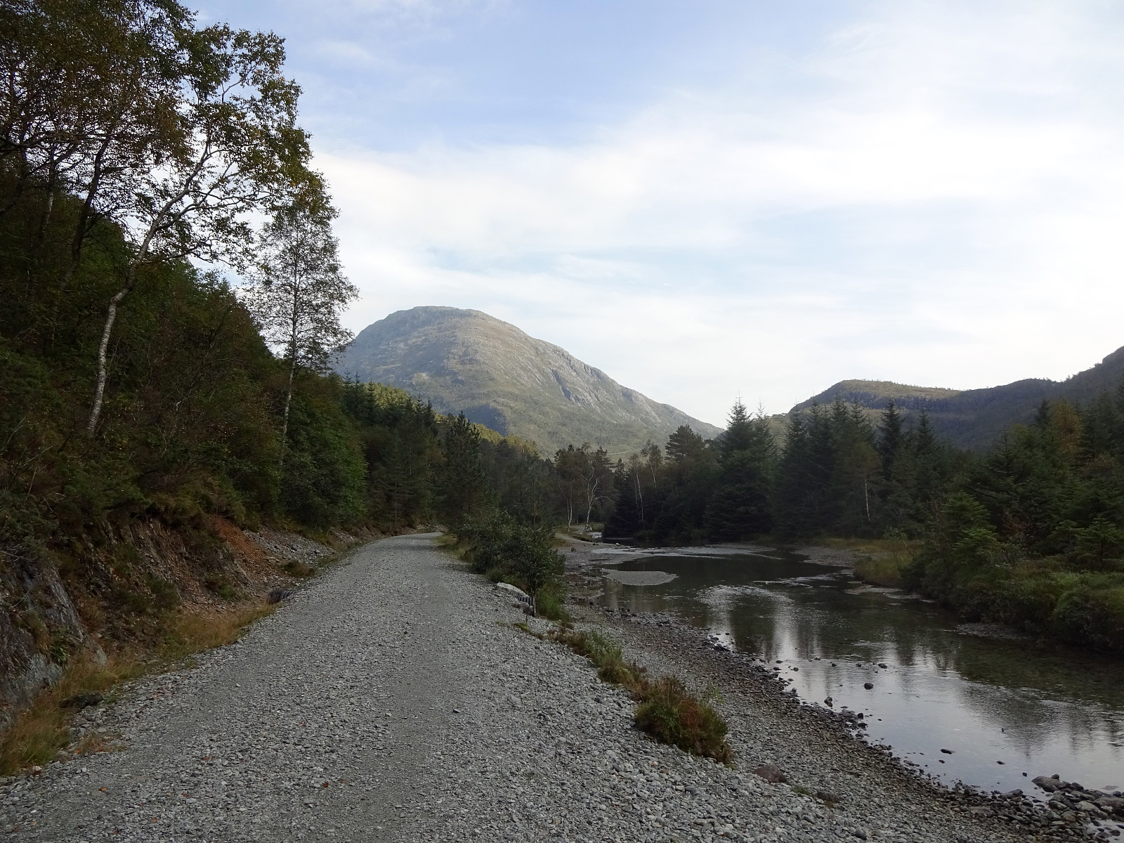
For a while, already, we had discussed that it absolutely was high time, again, for one of the nice classics in the vicinity of Bergen: up to Sydpolen from Brekkedalen! Since the weather seemed to hold throughout the day, we were quick to choose this hike for the day! :-) Driving into Hausdalen from E39 (south of Bergen), we aimed at the parking place at the very end of the road (basically where Brekkedalen splits off from Hausdalen). Hoping that we would not be too late to also find a free spot for our car, we then were relieved to actually find the parking place "only" half full (at about 11h). We quickly got started, heading into Brekkedalen along the gravel road. As soon as we approached Sandane, we also could look up to Sydpolen, already (always an impressive sight). Continuing along the gravel road, we aimed at the trail head on the "other" (eastern) side of Tverrelva (close to the big power line pole right north of the gravel road). Surprisingly, we managed to walk past this trail head (how often have we used this trail already in the past?!)! Some 400 meters further up the gravel road, we then realized that we most likely had missed "the exit"! :-) But instead of walking back down the gravel road, again, we made the decision to "short-cut" -- straight up, basically -- to the ridge (and the trail there). Stepping up the northern valley side of Brekkedalen was then possible without problems, but it's worth mentioning that this ascent is indeed very steep (a few times our hands came in handy :-) as additional support while stepping up). At about 450masl, we then rejoined the trail on the ridge up to Sydpolen. Onwards, it was then "just" to follow the ridge/trail all the way up to Sydpolen. If you're not as fit as Petter Bjørstad :-), you do recognize the 850 height meters between the parking lot and Sydpolen -- especially on a quite warm day! :-) On Sydpolen, then, we had the choice of either continuing further across Søre Gullfjellstoppen (into the direction of Gullfjellet and Gullfjelltoppen), or "cut short" via a trail that leads down to Gullfjelltjørnane via a (quite steep) ridge directly in the north of Sydpolen. While we had enjoyed the former variant already a few times in the past, we this time chose the "shorter round back". Following a long sequence of small cairns down to the lowest of Gullfjelltjørnane, we got the impression that the marking of this trail must have improved over the years! :-) After paying the lake a short visit, we then continued along the trail, crossing several of the streams that come down from Gullfjelltjørnane in this area. After stepping across Ålen, we walked for a few meters along the "Autobahn" (Korketrekkeren) between Redningshytten and Gullfjellet. But instead of stepping down along this main trail to the small lake in the north of Toro, we decided to cross over Hausdalsgullbotntoppen (in the east of the lake, steeply above it). While crossing over the heights of this ridge is very easy, it's not 100% trivial to connect further to Toro (due to a very steep western flank of this ridge). Avoiding the steepest section, however, we could make it down to the saddle between Hausdalsgullbotntoppen and Toro without major difficulties. From there, the continuation was nice and easy, again, and we even included the top of Toro -- just for fun! :-) Walking down Hausdalsåsen is then always a very nice way to round off this classical hike, especially on a nice afternoon. Only the very last height meters down to the gravel road in Brekkedalen require some care (the terrain is steep there and the trail leads mostly "straight down", also). Eventually, one steps -- almost through a small hole, in a way -- out and onto the gravel road near Sandane, again. The last stretch of walking back to the parking lot is a great opportunity to let the gathered impressions sink in! :-)
Photos
Selected photos are available as Google photo album.
Useful Resources
See also the related FB-page Hiking around Bergen, Norway.
Petter Bjørstad has a useful page about Sydpolen and also web page WestCoastPeaks.com provides useful information about S. Gullfjellstoppen.
Web page UT.no from the Norwegian Trekking Association recommends a similar hike (a short round, not including Gullfjellet).


User comments
"As fit as Petter" :)
Written by hbar 10.09.2023 20:20Thanks for sharing the link to the article with Petter! I had not seen this one before. I guess it is safe to say that not much has changed even though the article is now more than ten years old. :)