
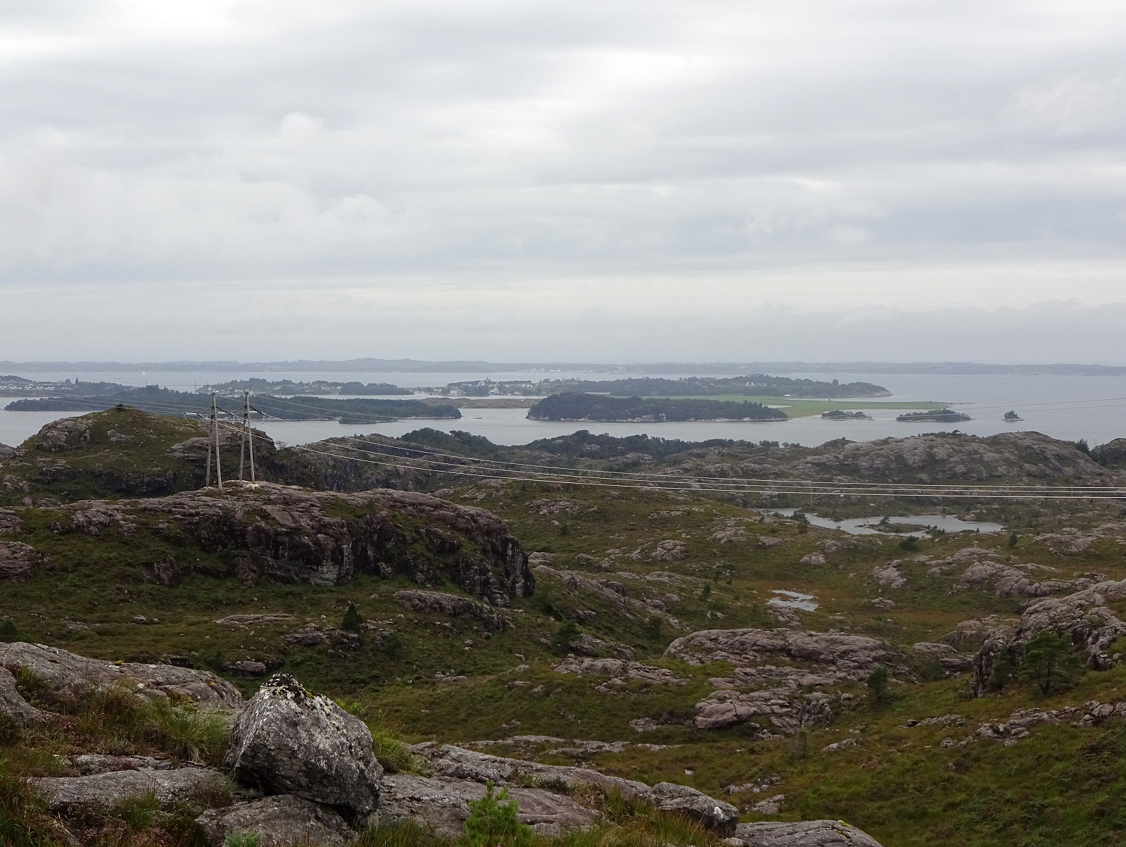
Eldsfjellet from the north (20.08.2023)

Written by HHauser (Helwig Hauser)

| Start point | Skjelangervegen (20m) |
|---|---|
| Endpoint | Skjelangervegen (20m) |
| Characteristic | Hike |
| Duration | 4h 00min |
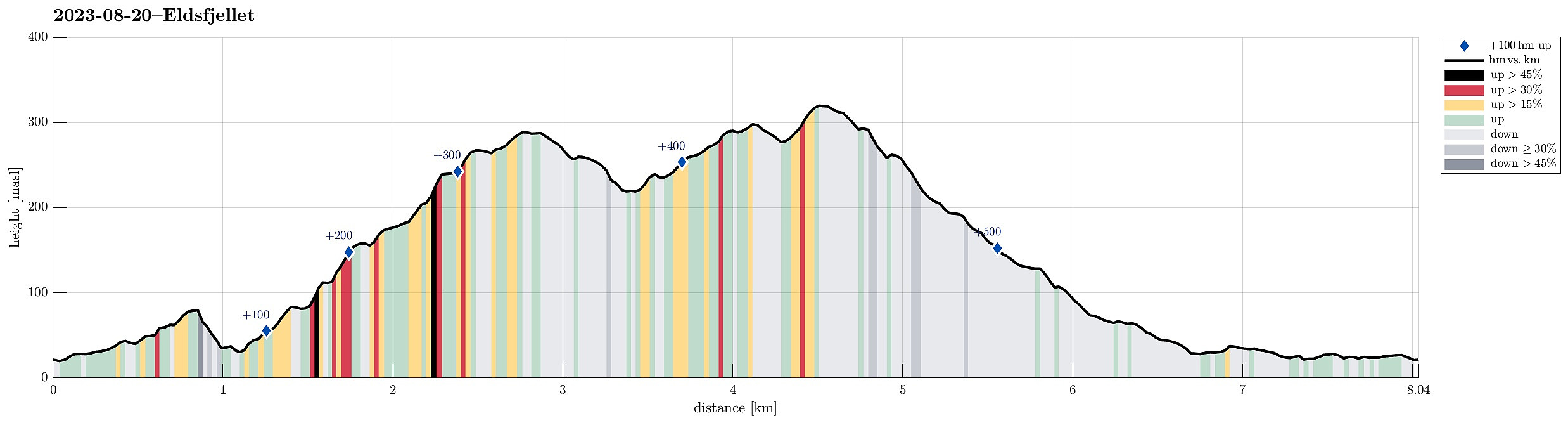
| Distance | 8.0km |
| Vertical meters | 552m |
| GPS |
|
| Ascents | Eldsfjellet (324m) | 20.08.2023 |
|---|---|---|
| Eldsfjellveten (294m) | 20.08.2023 | |
| Visits of other PBEs | Eldsbu (315m) | 20.08.2023 |
Trip Summary
We had not been on Eldsfjellet for a while -- not the two of us, at least! Eldsfjellet is -- for good reasons -- a relatively popular hiking destination (it's not really high, as a mountain, but since it's standing out of its surrounding quite a bit, one can expect quite nice views from its heights). Here on Peakbook, as well as on other hiking platforms, one can easily get the impression that everyone (or "everyone") hikes up to Eldsfjellet from its south, either from the parking spot near Alvhøyen along Skjelangervegen, or from Skurtveit via Skurtveitvegen. Harald's approach from the northwest is a notable exception, of course! :-) Even though it looked like off-trail a lot, we made a plan to approach Eldsfjellet from the north, instead. The idea was to follow Skjelangervegen further and around Eldsfjellet, passing by Kårbøtjørna and then starting to hike north of house #622. While we could make our first steps on a forest road (southwards from Skjelangervegen), we soon ended up without a trail. Our first intermediate goal was Storhøyen and we managed to find it without major deviations. From Storhøyen, we enjoyed some quite nice views southwards to Eldsfjellet. Next, we had to get down from Storhøyen, which has a several meters high cliff on its southern side. Thus, we went around (in the southeast of Storhøyen). All in all, this (short) descent from Storhøyen was maybe a tiny bit more of a challenge (steep, dense forest) than what we absolutely needed to have. :-) In the small valley in the south of Storhøyen, we then needed to cross a little stream that flows westwards into Brotshaugvatnet. After searching for a few meters, we luckily found a good spot for stepping over this stream. From the southern side of this stream, the continuation of our hike was easier and with less vegetation "in the way". Still, we were required to find our planned route that was supposed to bring us around the north-facing cliffs in the north of Veten. Luckily, identifying the right valleys to step up was not difficult and soon we made good progress on our ascent towards Veten (via Hjellane). Above 200masl, we even saw the one or other cairn, indicating that others also considered this approach as viable. Before actually stepping all the way up to Veten, we first headed a bit more towards the west so that we could look down the impressive western cliff-face of Veten (recommended view!). From there, it was then quick and easy to get to the actual top of Veten. Next, we wished to cross over to Eldsfjellet (Varden). Using the trail between Veten and Varden, we swiftly made it over to the other top (and to the new cabin right next to it!). To get back to our starting point, however, we then embarked on the second leg of our little Eldsfjellet adventure! :-) The first goal was to descend from Eldsfjellet and into this valley the extends in the north of Eldsfjellet from the southeast to the northwest without ending up in all too steep terrain. To do so, we thought that it would be best to "walk around" some of the steeper sections in the north of Eldsfjellet, heading into the direction of Storanipa (north of Kvitstigtjørna), first. While we did avoid steep terrain completely, this still worked quite well and within a few minutes we were in less steep terrain, aiming for the upper parts of this valley (in its southeast). Our map study had also indicated that walking down this valley would likely be easier on its northern (northeastern) side. We thus headed towards the "far side" of this valley, first, before then descending through this valley on its northern side. This worked very well and also helped us to find the spot, where this valley splits into a part that heads west (into Øyrdalen) and a part that heads north (the one that we wished to follow). Descending further, in northern direction, was then also easy and nice. Once down to about 40masl, however, vegetation became dense, again, and the last stretch of this hike (back to the car) promised to have some more challenges related to water and vegetation for us. :-) To get to Åsen, for example, required the crossing of some quite wet area. On Åsen and further northover the forest had been cut down, leaving a substantial chaos of cut down trees etc. (and making stepping over it less than pure pleasure). Near Tytebærvellena, we again ended up in very wet terrain, requiring a deviation from our originally planned route. All in all, and especially south of Storhøyen, hiking Eldsfjellet from the north is not only possible, but also very nice (north of Storhøyen, we'd be tempted to try something else, however, than what we did this time).
Photos
Selected photos are available as Google photo album.
Useful Resources
See also the related FB-page Hiking around Bergen, Norway.
Petter Bjørstad has a useful page about Eldsfjellet and also web page WestCoastPeaks.com provides useful information about Eldsfjellet and Veten.


User comments