
Buren (and an attempt to Rødtinden) (01.07.2023)

Written by HHauser (Helwig Hauser)

| Start point | Naustbuktvegen (5m) |
|---|---|
| Endpoint | Naustbuktvegen (5m) |
| Characteristic | Hike |
| Duration | 4h 30min |
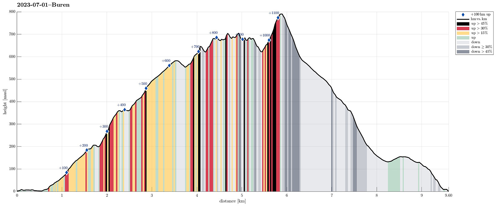
| Distance | 9.6km |
| Vertical meters | 1,155m |
| GPS |
|
| Ascents | Buren (802m) | 01.07.2023 |
|---|
While the main trail up to Buren is easy and nice, some extra care is required when including an attempt to Rødtinden, also!
Trip Summary
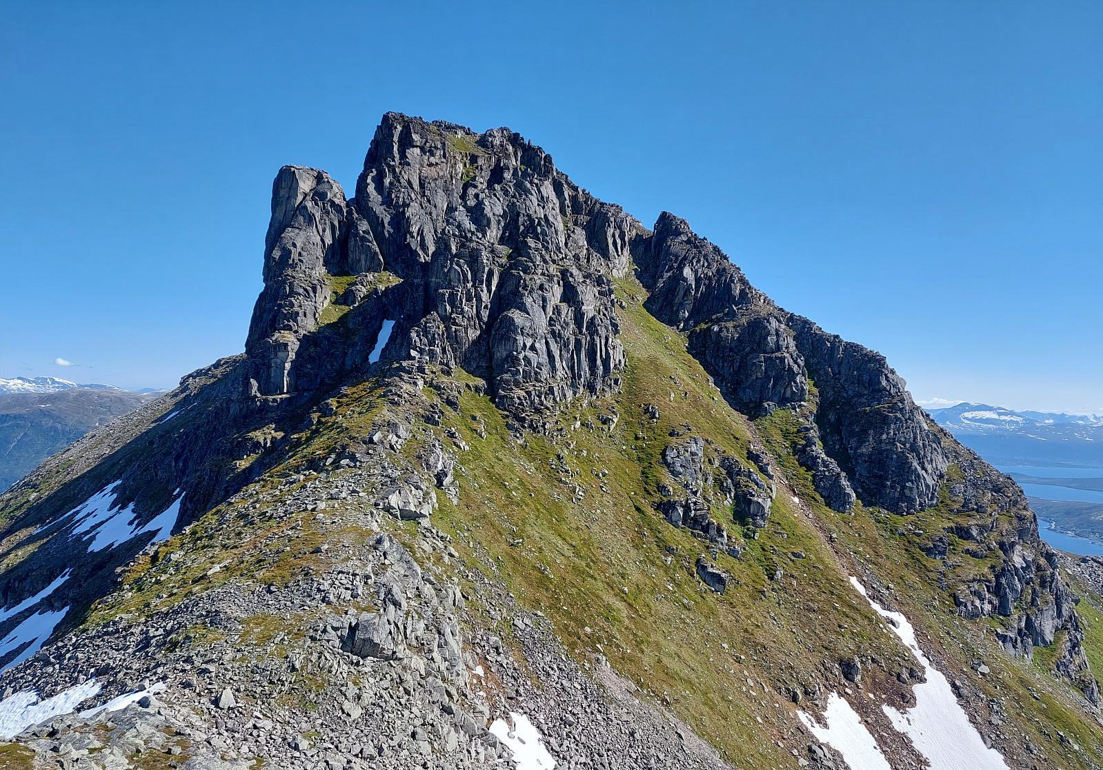
We had relocated ourselves from Senja to Kvaløya (to Ersfjordbotn -- as if there wasn't any Ersfjorden on Senja!). Also this day looked very promising and with wonderful mountains just "around the corner", the plan was to hike up to Buren (without driving). The hidden agenda for this hike was to also try an ascent to Rødtinden, if possible. Starting along Naustbuktvegen, I first walked along the coast into the direction of Gottberget. There, I found a trail that lead me up to a simple ridge which comes down from Skålhammaren (further up in the northeast of Gottberget). Also along this ridge, I could find a simple trail, leading me up to a nice viewpoint at about 200masl (also with a small cairn there). From there, however, I could not find any trail that would lead further upwards -- instead, I had the impression that I could follow a simple trail further down towards the east. Since Skålhammaren was my (intermediate) goal, I decided to ascend from there without any trail. The southern flank of Skålhammaren is significantly steep and one should only get up there, if one is ready for a slightly more demanding ascent (not really difficult, but a bit of a challenge, still). Once at Skålhammaren, the continuation was easy, following the main trail that eventually leads up to Buren. About 200 height meters below the top of Buren, where the main trail turns right (into a northward direction, steeply up to the top of Buren), I continued further westwards to get around Buren. This way, I could step around the southwestern cliffs of Buren, but doing so required some extra care (the terrain is very steep there and even though I could basically traverse it on grass, I still thought that increased attention was needed to avoid any stupid mishap (any fall there may have serious consequences!). Staying close to the lower end of the southwestern cliffs of Buren, I aimed at the main western ridge of Buren, which then leads down to the saddle between Buren (in the east) and Rødtinden (in the west). While it took me longer than on a regular trail, I still could make it to this ridge (and to the saddle) without problems. The continuation towards Rødtinden then follows a quite rugged ridge with lots of ups and downs. At times, a bit of climbing is also necessary to make further progress. About half way between Buren and Rødtinden, one gets up to an intermediate high-point with amazing views in all directions. Further to the west, one then needs to descend again and find a way along the southern side of the ridge (at about 700masl). Since the (very steep) terrain is kind of loose at times, some special care is also needed there. Maybe only 200 meters from Rødtinden, I then decided to turn around. I would have had another steep descent over loose terrain in front of me, followed by a part, where I would have had to cross over a very steep snow field. Being just by myself, I did not find this passage safe enough (at least not for me) and thus turned around. Paying good attention on my way back, I found all the necessary connections along the ridge and soon was back at the saddle. From there, I had already checked in advance that it should be possible to get up to Buren from its western side. Indeed, this ascent was well possible (while very steep, yes) and not long after I found myself on the upper-most section of the main trail to Buren. A few steps later, I was on the top, enjoying an amazing all-around view from there. The first 200 heights meters down from Buren (along the main trail) are "straight-forward" but special care is still recommended (also along this trail, there's at times some sand on top of the rocks, making the steep descent a bit slippery). Once down to about 600 masl, the following descent along the main trail is easy and relaxing. Once on Ramnberget, I thought that I could cut short my descent by aiming directly at Naustbuktvegen (in western / southwestern direction). I had remembered that I had seen a trail marked on the map northwest of Naustbuktvegen, but while aiming at this trail from Ramnberget, I descended too much too early, ending up on the southeastern side of the little stream that comes down alongside Klipa. All of this was not really a problem (I could find my way down through the trees there), but I would not recommend anyone else to follow this section of my hike. :-) All in all, this hike had all from the adrenaline-pumped attempt to Rødtinden to the relaxed hike down from Buren (once below 600masl). :-)
Photos
Selected photos are available as Google photo album.
Useful Resources
See also the related FB-page Hiking around Bergen, Norway.


User comments