
Erdalsvarden from Bratland (or so) (13.05.2023)

Geschrieben von HHauser (Helwig Hauser)

| Startpunkt | Søylen parking (85m) |
|---|---|
| Endpunkt | Søylen parking (85m) |
| Tourcharakter | Wanderung |
| Tourlänge | 4h 30min |
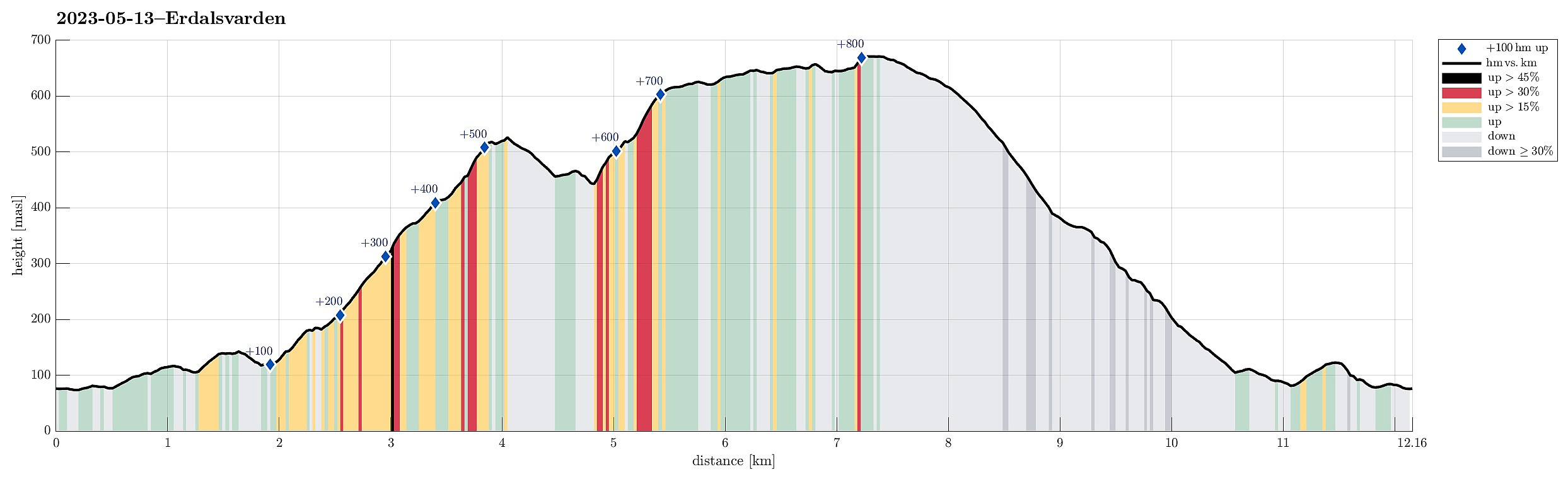
| Entfernung | 12,2km |
| Höhenmeter | 880m |
| GPS |
|
| Besteigungen | Byfjellenes høyeste punkt (674m) | 13.05.2023 |
|---|---|---|
| Hauggjelsvarden (673m) | 13.05.2023 | |
| Søyleåsen (129m) | 13.05.2023 | |
| Vasslifjellet (629m) | 13.05.2023 | |
| Besuche anderer PBE | Erdalsvarden (458m) | 13.05.2023 |
| Grytebakkbrua (180m) | 13.05.2023 | |
| Haukelandsvarden (640m) | 13.05.2023 | |
| Lidskjalv (625m) | 13.05.2023 | |
| Noreg (634m) | 13.05.2023 | |
| Søylen p-lomme (85m) | 13.05.2023 | |
| Turnerhytten (642m) | 13.05.2023 |
Trip Summary
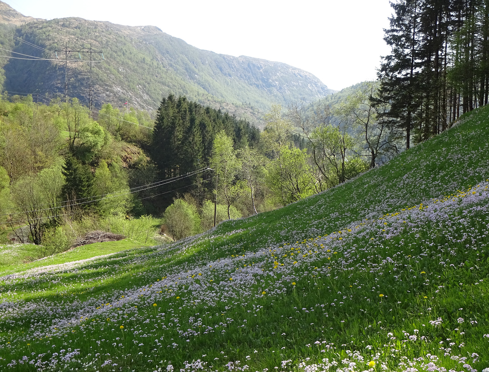
We picked up an older plan to visit Erdalsvarden from Bratland and drove past Grimevatnet to the south of Søylevatnet (along the main road to Arna). We parked where on also can take a trail (in southern direction) to get up to Furedalen. Instead, however, we headed (at large) in northward direction, passing Søylevatnet in its east. We then continued along the ridge that extends from Borgnyhaugen (in the southwest) to Krunhaugen (in the northeast). From there, we followed (for a short stretch) the road up to Øvre Bratland, before turning left at house 146 and then walking along the old postal route between Bergen and Christiania (nowadays Oslo). This brought us to the saddle where one could then continue downwards again (towards Erdalen in southwestern direction). There, we turned right in order to follow the trail upwards that is marked towards Ulriken. Our goal was to find the trail that would then bring us up to Erdalsvarden (from somewhere on the top of Gråsmoglia). Even though we tried to pay attention carefully, we still missed the place, where this trail forks off and instead followed the main trail towards the valley where Grytebakkelva comes down. At about 450mosl, however, we recognized that we had missed the trail to Erdalsvarden for sure and thus decided to connect to Erdalsvarden off-trail. Even though the slopes are relatively steep there, it was still no problem to find a reasonable connection (yes, a few times we were required to step through some juniper bushes -- no bg deal, however! :-)). The only "thing" was that we came out a bit higher than Erdalsvarden (some 75 height meters too high), which made us discuss whether Erdalsvarden was really that worthwhile a hiking target. :-) After a short discussion, the one of us two convinced the other one that it absolutely was worthwhile to step down the gentle slopes and visit Erdalsvarden! :-) While kindly coming along, the originally convinced one did not really confirm the significance of Erdalsvarden (and I'd suspect that it will take us a while before returning to this place). From Erdalsvarden, we then continued in western direction, crossing through Fossekrærne in order to connect to Soleibakkane. Instead of making it all the way to the trail up Soleibakkane, however, we simply chose to "short-cut" up the mountain side off-trail, aiming for a nice cairn on the southern end of Vasslifjellet. There, we enjoyed a really nice lunch break (with some nice sun!), before continuing. Walking across the heights of Haukelandsstikkene, we then passed by Turnerhytten. From there, we aimed at Hauggjeldsvarden, requiring some navigation around wet areas in the northwest of Øvstegjeldsvatnet. From Hauggjeldsvarden, we then followed Jubileumsstien down into the direction of Bratland. North of Gjertrudbotn, we then left Jubileumsstien and followed the markers of RettVest further towards Bratland. While mostly easy to follow, this trail is not always fully visible, especially in the northwest of Vårdalsmyra. Still, it was no problem to get all the way down to Øvre Bratland, where we had turned left onto the old postal route in the beginning. Walking down (again) Brattlandsvegen, we this time continued further down along the road until we crossed the rail tracks near the main road. Instead of then following the main road back to our car, we decided to cross over Søyleåsen, instead. Only the very few last meters, then, we walk along Hardangervegen to get back to our car. All in all, this hike came with a strong spring feeling, especially in the lower parts at Bratland, where lots of flowers were out as well as sheep and their lambs. :-)
Photos
Selected photos are available as Google photo album.
Useful Resources
See also the related FB-page Hiking around Bergen, Norway.
Web page WestCoastPeaks.com provides useful information about Haugavarden, Ulriken, Storfjellet, and Landåsfjellet
and also Petter Bjørstad has a useful page about Ulriken.
Web page UT.no from the Norwegian Trekking Association recommends another hike up to Erdalsvarden.


Benutzerkommentare