
Slettegga, Austefjellet, and Hausdalshorgi (22.04.2023)

Geschrieben von HHauser (Helwig Hauser)

| Startpunkt | Øvstebøvegen (220m) |
|---|---|
| Endpunkt | Øvstebøvegen (220m) |
| Tourcharakter | Wanderung |
| Tourlänge | 4h 30min |
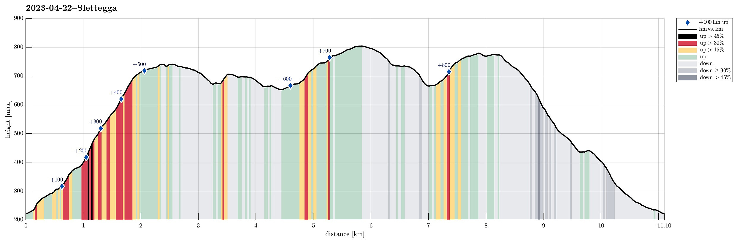
| Entfernung | 11,1km |
| Höhenmeter | 888m |
| GPS |
|
| Besteigungen | Austefjellet (806m) | 22.04.2023 |
|---|---|---|
| Hausdalshorga (781m) | 22.04.2023 | |
| Nobbane (711m) | 22.04.2023 | |
| Slettegga (742m) | 22.04.2023 | |
| Besuche anderer PBE | Bjørnastølen (376m) | 22.04.2023 |
| Varden på Hausdalshorga (775m) | 22.04.2023 |
Trip Summary
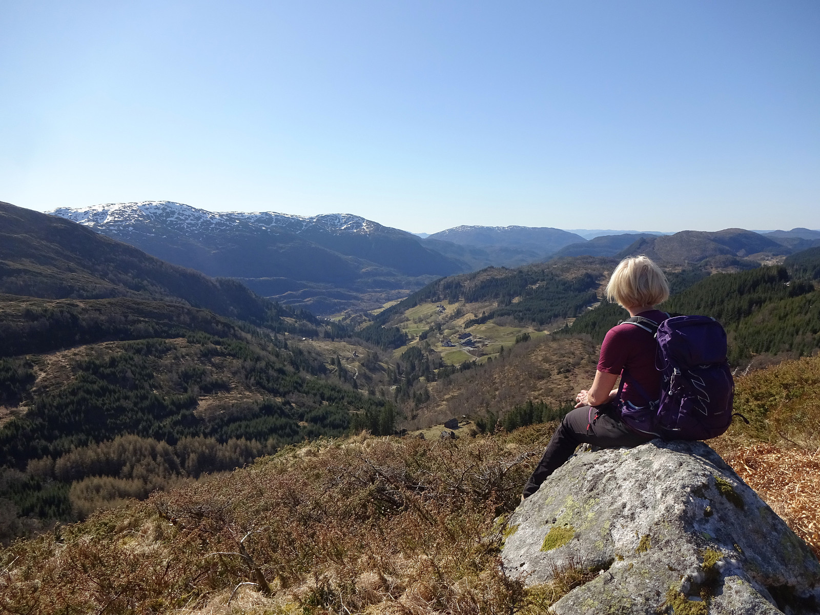
It looked like a wonderful spring day and we had a couple of hours. Since we had talked about Slettegga, already, we decided to try a new ascent to Slettegga -- via its southern ridge (up from Bjørnastølen). We drove into the valley of Bontveit (up from Kalandsvatnet) and over the saddle at the high end of the valley and further onto Øvstebøvegen. Near the low point of this road, before crossing over the stream that comes down from the north, we parked and started our hike. Near the bridge over the stream, we left the road to the left and ascended (quite steeply) up Lurabakken. After stepping through a few trees at about 260masl, we continued along a simple trail that leads northwards on the western side of the stream (in parallel to the stream). At about 315masl, we then crossed one of the tributaries to that stream, continuing further upwards and to Bjørnastølen from there. From Bjørnastølen, we then headed "straight for the ridge", starting the actual ascent along this ridge at about 400masl. The lower stretch of this ridge is not exactly perfect for an ascent (one needs to find a way between quite a few juniper bushes there), but it's clearly possible without all too much of a bush war. :-) Some 100 height meters further up, one gets the first wonderful view (back towards the south)! From about 550masl, then, the ascent gets a bit easier, while still being steep. At about 640masl, we again enjoyed the nice views and the wonderful sunshine! :-) Eventually, this ridge leads almost directly up to the top of Slettegga. There, we decided to take a bit of time for a very nice break. After considering the available time, we then thought that we could still do the bigger round back (via Austefjellet and Hausdalshorgi). We first followed the trail from Slettegga in northeastern direction, ascending to Nobbane on our way, also. From there, we continued along the ridge towards the saddle (Rundehaugen) from where one gets up to Austefjellet. On the way up to Austefjellet, we crossed a substantial amount of snow, still. The soft layer on top was not too deep, making progress well possible. We then crossed over Austefjellet and continued into the direction of Hausdalshorgi. All of this was very nice, in beautiful sunshine. We then crossed Horgahalsen to start our ascent to Hausdalshorgi. Also there, we faced quite a bit of snow. The conditions were however good and getting up to Hausdalshorgi was straight-forward. From Hausdalshorgi, we then followed the trail down (towards the bridge over Dyrdalselva). This trail suffers from all the hikers, by now, and one wonders, where this will lead in the coming years. After crossing Dyrdalselva via the very convenient bridge, we then descended to Øvstebøvegen using the trail on the northwestern side of Dyrdalselva. Once down at the road, it was then only a few minutes back to our car. All in all, this hike was outstanding, especially given the wonderful weather! :-)
Photos
Selected photos are available as Google photo album.
Useful Resources
See also the related FB-page Hiking around Bergen, Norway.
Petter Bjørstad has a useful page about Hausdalshorgi and also web page WestCoastPeaks.com provides useful information about Hausdalshorgi.
Web page UT.no from the Norwegian Trekking Association recommends a similar hike.


Benutzerkommentare