
Førdesveten from Vorland (18.03.2023)

Written by HHauser (Helwig Hauser)

| Start point | Sundvegen (45m) |
|---|---|
| Endpoint | Sundvegen (45m) |
| Characteristic | Hike |
| Duration | 4h 00min |
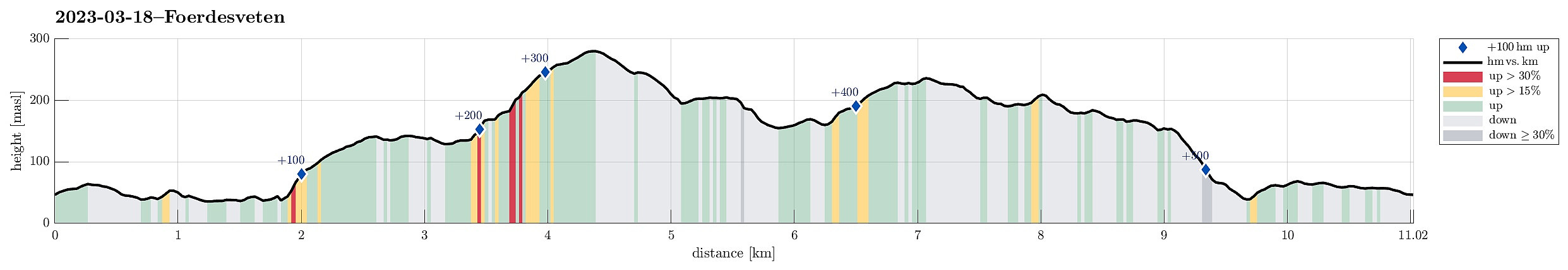
| Distance | 11.0km |
| Vertical meters | 540m |
| GPS |
|
| Ascents | Førdesveten (284m) | 18.03.2023 |
|---|---|---|
| Randifjellet (240m) | 18.03.2023 | |
| Vorlandstua (216m) | 18.03.2023 | |
| Visits of other PBEs | Vorland rasteplass (58m) | 18.03.2023 |
Trip Summary
We decided to hike Førdesveten in the south of Sotra and planned for an approach from the northwest (from Vorland). After driving south from Fjell, we parked along Sundvegen, where one also finds the head of a trail that leads through Grøndalen into the direction of Vorlandsvatnet. Using this trail, we approached Vorlandsvatnet at Vassvika from the northwest, following a trail that passes by Vorlandsvatnet in its northeast. This is a nice and convenient trail that leads all the way to the southern-most point of Vorlandsvatnet. There, one could "back out", again, following a gravel road towards the west. Instead, we entered the little valley that comes down there from the south (mostly). After only about 100m into this valley, we ascended (kind of steeply) to the southeast, leading us out of this valley and towards the northeastern side of Ravnastegen. Once up and out of the valley, we passed the spot, where one could also turn towards Vorlandstua (in the northeast). Only a very short stretch after this trail-junction, we came to a basic building (north of Ravnastegen) and decided that it was about the right place to leave the trail and head towards the ridge of Ravnastegen, which extends kind of parallel to the trail. It wasn't difficult to find a route between the trees up to the ridge and from there, we could enjoy some nice views -- not the least also southwards (towards Strandafjellet). We then walked along the ridge of Ravnastegen (into the direction of Veten). From studying the map, we knew that getting up to the trail that would then continue further upwards to the top of Førdesveten (along the northwestern ridge of Veten) may be best via a small valley that leads down from this ridge in (mostly) southern direction. This leads to a route that surrounds the most northwestern end of Veten's northwestern ridge (where it drops into Grindavatnet) in the south -- probably to avoid some of the cliffs a bit further north. Once we had reconnected with the trail, the following ascent via the ridge to Førdesveten was very nice (it was a bit icy in a few places, but nothing that would cause any problems). We then had a nice, short break on the top of Veten, before descending into eastern direction (in parallel of the power line that leads up to the mast on Veten there). Once back down below about 200masl, we crossed the wet area that separates the main heights of Førdesveten from Gombestegen in the northeast. We then, instead of following the main trail further down towards Førde and Førdesvatnet, we crossed over Gombestegen, heading towards Åsendalen and the trail that leads up to Randifjellet from there. To get down into Åsendalen, we surrounded some minor cliffs in the northwest of Gombestegen. Then, only a few height meters down in Åsendalen, we found the trail that leads out of Åsendalen and further towards Randifjellet and followed it to the place, where it crosses the outflow of Nyatrævatnet. With a quite a bit of water there, we first were a bit worried about how to get over -- eventually, however, and luckily, it wasn't too bad and we could continue nicely along this trail towards Randifjellet. Before actually reaching the top of Randifjellet, we enjoyed for a moment a cliff in the southeast of the top of Randifjellet. From Randifjellet, we then continued towards Vorlandstua, passing by Kvitursfjellet in its east. One comes by two (or three) small lakes between Randifjellet and Vorlandstua. The terrain was very wet there, also due to melting snow etc., but not to the degree that we could not make progress. :-) From Vorlandstua, we continued further into northwestern direction. Before starting our descent via Svartaberget, we enjoyed some nice sun at Såta. After then stepping down Svartaberget (careful, because of ice and snow!), we basically just aimed for getting back to our car. Near Vardhaugen, however, we then followed a simple road towards the north, which lead to a short, not really planned detour before actually getting back. :-)
Photos
Selected photos are available as Google photo album.
Useful Resources
See also the related FB-page Hiking around Bergen, Norway.
Petter Bjørstad has a useful page about Veten and also web page WestCoastPeaks.com provides useful information about Førdesveten.


User comments