
Gråfjellet via Solbjørgfjellet from Rolsvåg (05.03.2023)

Geschrieben von HHauser (Helwig Hauser)

| Startpunkt | Solbjørgvegen (45m) |
|---|---|
| Endpunkt | Solbjørgvegen (45m) |
| Tourcharakter | Wanderung |
| Tourlänge | 6h 00min |
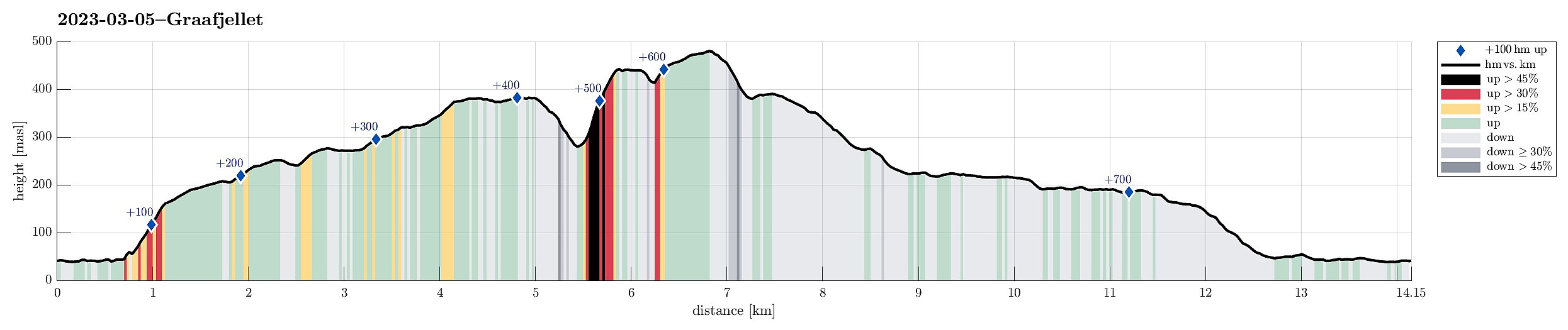
| Entfernung | 14,2km |
| Höhenmeter | 730m |
| GPS |
|
| Besteigungen | Gråfjellet (485m) | 05.03.2023 |
|---|---|---|
| Midtfjellet (446m) | 05.03.2023 | |
| Strandafjellet (387m) | 05.03.2023 | |
| Besuche anderer PBE | Botnahytto (220m) | 05.03.2023 |
| Strandafjellet varde (385m) | 05.03.2023 |
Trip Summary
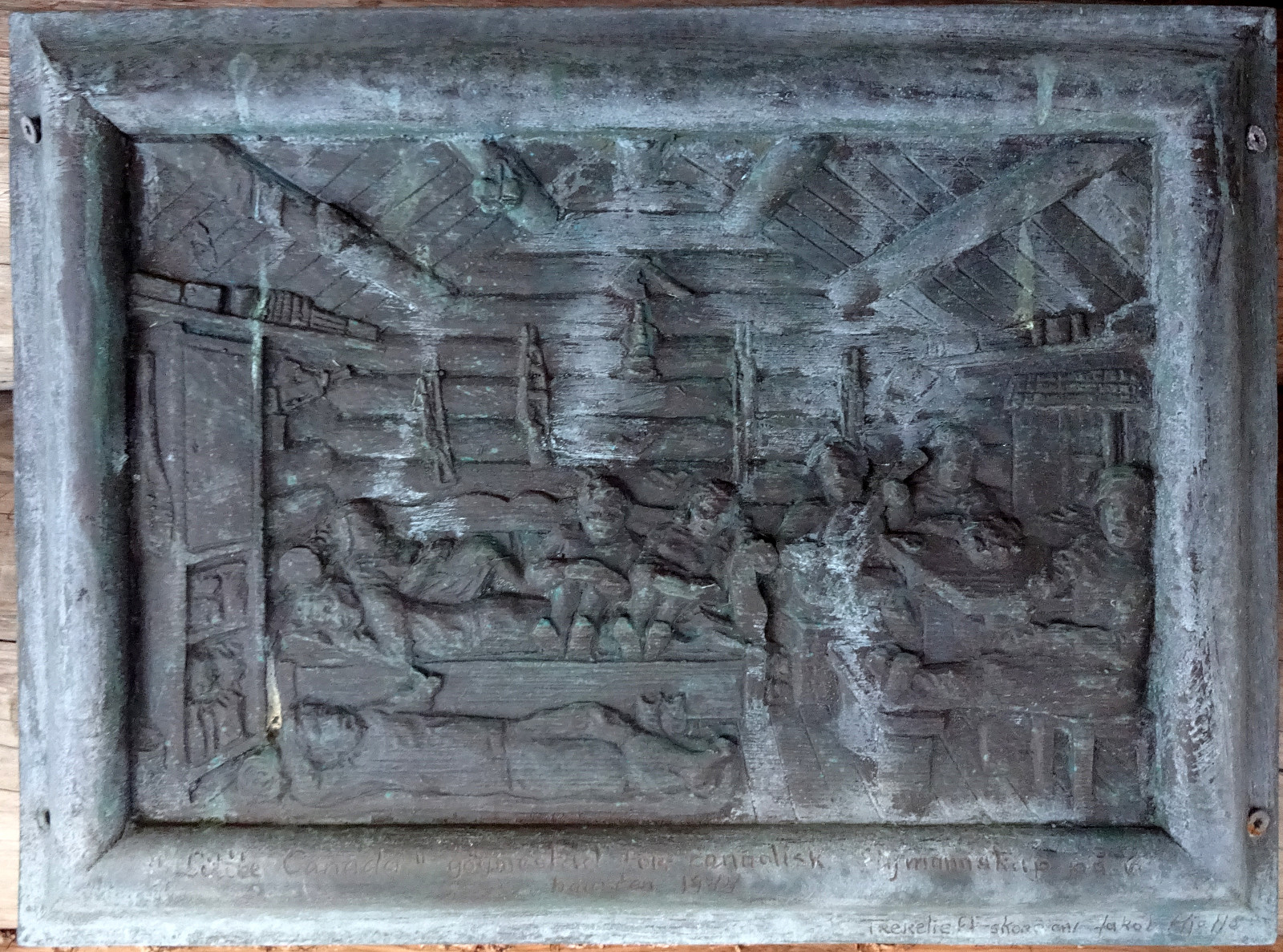
Expecting a nice day, we made a plan for a hike that would not lead us up into all too much snow. Having seen that Botnahytto (in the southwest of Rolsvåg, north of Os) was registered as war memorial, also, we decided to explore this area, including Gråfjellet in the east of Øvredalsvatnet. We had seen that others had taken the forest road from Rolsvåg (passing Rolsvågvatnet, also called Storavatnet, in its north) to get into the valley with Langavatnet and Botnavatnet. Motivated to make this a round, instead, we decided to start our hike in the south of Rolsvågvatnet, aiming for Solbjørgfjellet first. We parked very near to Rolsvågvatnet (on the east of it) and stepped into the terrain south of Rolsvågvatnet more or less "at once". The ground was still quite a bit frozen, which helped with making progress along the lake (where in warmer times one may expect some wet terrain, instead). The plan was to get up to the ridge between Revadalen and Lauvlidalen. All this worked very well and very soon we were stepping up this ridge (without a trail, but still "nice and easy"). Staying on the northwestern side of Revadalen, we hiked the ridge all the way up to a little height east of Langavatnet. To continue further up (into the direction of Strandafjellet), we then "crossed over" (in southeastern direction) to get over to Solbjørgfjellet. While still well covered with snow, making progress was not difficult and the nice weather contributed to making this hike up Solbjørgfjellet a very nice experience! :-) We then followed the heights of Solbjørgfjellet further upwards (in southwestern direction) to get up to Strandafjellet. There, we first visited the large cairn (a bit northeast of the top of Strandafjellet). From there, we then crossed over the top of Strandafjellet further in southwestern direction with the goal to find a suitable spot for getting over to Midtfjellet. The western side of Strandafjellet is quite a bit steep and descending into the valley between Strandafjellet and Midtfjellet requires some care. We still found a route that wasn't too difficult, also not with all the snow there. Once down in the valley, the next challenge was to get up to Midtfjellet, which also is quite a bit steep on its eastern side. Without fiddeling too much around, i.e., by choosing a quite direct route up, we quickly made the height meters needed to get up to Midtfjellet (at times we appreciated the help of our hands while doing so). By first ascending a bit more into southwestern direction before then continuing further northwards, one may possibly avoid the steepest sections of the route that we took. Clearly, it was then good to arrive at the top of Midtfjellet! :-) After a short break to refill some energies, we then continued towards Gråfjellet (to get there, one needs to make a little detour around the saddle in the northeast of Gråfjellet). With quite a bit of snow between Midtfjellet and Gråfjellet, we made this crossing very carefully, arriving at Gråfjellet not so very much later. After enjoying the views from Gråfjellet, we decided to continue without any further delay. We knew that the northwest of Gråfjellet is also quite steep, but that one can get down there by finding a "diagonal" that is (kind of) "cutting across" the northwest face of Gråfjellet (in western direction). Following an animal track in the deep snow, we located this/a diagonal without difficulties and made it down to Leina without and difficulties. We then followed the ridge of Leina into the direction of Baggeskaret, where we hoped to find a trail that would lead us down into the valley with Botnavatnet and Langavatnet. When following this ridge, one better leaves it a bit above Baggeskaret (to the left, north) in order to avoid all too steep terrain. Once in Baggeskaret, we could not see any trail (it's quite possible that this would have been easier without the snow). Instead, we just started our descent towards Sætertjørna where we thought that the trail may be. Indeed, after descending some 10 or 20 height meters, we could see some worn out markings on some trees (so there is a trail and it was marked at some time :-)). When close to Sætertjørna, however, we thought that we should head more towards the north (in order to get to Botnavatnet). This impression was correct and after "crossing over" to the north, we arrived at Botnavatnet soon after that. Botnahytto is situated on a peninsula that extends into Botnavatnet from the northeast. Since we had arrived there from the south, we took a short-cut over the lake, which was well frozen, still. Unfortuantely, it was not possible to get into the cabin (through the window it looked as if more would be to see in there, relating to a story of seven Canadians hiding there from the German troops during WWII. At least a small wood-carving on the outside of the cabin provided an impression. While then walking out (now along the trail and then the forest road) towards Rolsvåg, we passed by a place where more information was provided (see the photo). Following the trail and forest road out to Rolsvåg was then without special surprises (maybe besides the ice that made selected stretches quite slippery). At the very end, we had to walk a short stretch back along the road (Solbjørgvegen), but that wasn't any big deal, neither. Altogether, this hike was a bit longer (also because quite a bit of it is without a trail); the terrain near Strandafjellet, Midtfjellet, and Gråfjellet is also quite steep in many places, so some care is advised. Hiking up Solbjørgfjellet (in nice weather!) was definitely a highlight! :-)
Photos
Selected photos are available as Google photo album.
Useful Resources
See also the related FB-page Hiking around Bergen, Norway.
Web page WestCoastPeaks.com provides useful information about Gråfjellet as well as about Sveningen, Søtefjellet, Sauskolten, Rindafjellet, and Midtsæterfjellet
and also Petter Bjørstad has a useful page about Gråfjellet and another useful page about Sveningen.


Benutzerkommentare